Cozes
| Cozes | ||
|---|---|---|
 |
| |
| Staat | Frankreich | |
| Region | Nouvelle-Aquitaine | |
| Département (Nr.) | Charente-Maritime (17) | |
| Arrondissement | Saintes | |
| Kanton | Saintonge Estuaire | |
| Gemeindeverband | Royan Atlantique | |
| Koordinaten | 45° 35′ N, 0° 50′ W45.584166666667-0.83027777777778Koordinaten: 45° 35′ N, 0° 50′ W | |
| Höhe | 10–59 m | |
| Fläche | 16,56 km² | |
| Einwohner | 2.161 (1. Januar 2021) | |
| Bevölkerungsdichte | 130 Einw./km² | |
| Postleitzahl | 17120 | |
| INSEE-Code | 17131 | |
| Website | www.cozes.fr | |
 Rathaus (Hôtel de ville) | ||


Cozes ist eine französische Gemeinde mit 2161 Einwohnern (Stand 1. Januar 2021) im Département Charente-Maritime in der Region Nouvelle-Aquitaine; sie gehört zum Arrondissement Saintes und zum Kanton Saintonge Estuaire.
Nachbargemeinden von Cozes sind Grézac im Norden, Saint-André-de-Lidon im Osten, Épargnes im Süden, Arces im Südwesten sowie Semussac im Westen.
Bevölkerungsentwicklung
| Jahr | 1962 | 1968 | 1975 | 1982 | 1990 | 1999 | 2007 | 2017 |
| Einwohner | 1579 | 1653 | 1697 | 1746 | 1730 | 1830 | 1925 | 2142 |
Sehenswürdigkeiten
- Kirche Saint-Pierre (12. Jahrhundert, Monument historique)
- Markthalle (15./18. Jahrhundert, Monument historique)
Siehe auch: Liste der Monuments historiques in Cozes
-
 Kirche Saint-Pierre
 -
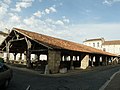 Markthalle


Literatur
- Le Patrimoine des Communes de la Charente-Maritime. Flohic Editions, Band 1, Paris 2002, ISBN 2-84234-129-5, S. 224–226.
Weblinks
Commons: Cozes – Sammlung von Bildern, Videos und Audiodateien
- Notice Communale - EHESS
Normdaten (Geografikum): VIAF: 170317863


