Agnetz, Oise
Commune in Hauts-de-France, France

Coat of arms
Location of Agnetz

(2020–2026) Stéphanie Ansart[1]
1
(2021)[2]
60007 /60600
(avg. 61 m or 200 ft)
Agnetz (French pronunciation: [aɲɛ(ts)]) is a commune in the Oise department in northern France.
Population
| Year | Pop. | ±% p.a. |
|---|---|---|
| 1968 | 1,118 | — |
| 1975 | 1,373 | +2.98% |
| 1982 | 1,801 | +3.95% |
| 1990 | 2,134 | +2.14% |
| 1999 | 2,637 | +2.38% |
| 2007 | 2,842 | +0.94% |
| 2012 | 2,977 | +0.93% |
| 2017 | 3,050 | +0.49% |
| Source: INSEE[3] | ||
Heraldry
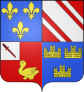 | The arms of the commune of Agnetz are blazoned : Quarterly, 1: Azure, 3 fleurs-de-lys Or; 2: Gules, a bend coticed argent; 3: Gules, a martlet Or and on a canton argent a dagger inverted bendwise gules; 4: Azure, 3 triple-towered castles Or.
|
See also
References
- ^ "Répertoire national des élus: les maires" (in French). data.gouv.fr, Plateforme ouverte des données publiques françaises. 13 September 2022.
- ^ "Populations légales 2021". The National Institute of Statistics and Economic Studies. 28 December 2023.
- ^ Population en historique depuis 1968, INSEE
Wikimedia Commons has media related to Agnetz.
- v
- t
- e
Communes of the Oise department 

- Abancourt
- Abbecourt
- Abbeville-Saint-Lucien
- Achy
- Acy-en-Multien
- Les Ageux
- Agnetz
- Airion
- Allonne
- Amblainville
- Amy
- Andeville
- Angicourt
- Angivillers
- Angy
- Ansacq
- Ansauvillers
- Antheuil-Portes
- Antilly
- Appilly
- Apremont
- Armancourt
- Arsy
- Attichy
- Auchy-la-Montagne
- Auger-Saint-Vincent
- Aumont-en-Halatte
- Auneuil
- Auteuil
- Autheuil-en-Valois
- Autrêches
- Avilly-Saint-Léonard
- Avrechy
- Avricourt
- Avrigny
- Babœuf
- Bacouël
- Bailleul-le-Soc
- Bailleul-sur-Thérain
- Bailleval
- Bailly
- Balagny-sur-Thérain
- Barbery
- Bargny
- Baron
- Baugy
- Bazancourt
- Bazicourt
- Beaudéduit
- Beaugies-sous-Bois
- Beaulieu-les-Fontaines
- Beaumont-les-Nonains
- Beaurains-lès-Noyon
- Beaurepaire
- Beauvaispref
- Beauvoir
- Béhéricourt
- Belle-Église
- Belloy
- Berlancourt
- Berneuil-en-Bray
- Berneuil-sur-Aisne
- Berthecourt
- Béthancourt-en-Valois
- Béthisy-Saint-Martin
- Béthisy-Saint-Pierre
- Betz
- Bienville
- Biermont
- Bitry
- Blacourt
- Blaincourt-lès-Précy
- Blancfossé
- Blargies
- Blicourt
- Blincourt
- Boissy-Fresnoy
- Bonlier
- Bonneuil-en-Valois
- Bonneuil-les-Eaux
- Bonnières
- Bonvillers
- Boran-sur-Oise
- Borest
- Bornel
- Boubiers
- Bouconvillers
- Bouillancy
- Boullarre
- Boulogne-la-Grasse
- Boursonne
- Boury-en-Vexin
- Boutencourt
- Bouvresse
- Braisnes-sur-Aronde
- Brasseuse
- Brégy
- Brenouille
- Bresles
- Breteuil
- Brétigny
- Breuil-le-Sec
- Breuil-le-Vert
- Briot
- Brombos
- Broquiers
- Broyes
- Brunvillers-la-Motte
- Bucamps
- Buicourt
- Bulles
- Bury
- Bussy
- Caisnes
- Cambronne-lès-Clermont
- Cambronne-lès-Ribécourt
- Campagne
- Campeaux
- Campremy
- Candor
- Canly
- Cannectancourt
- Canny-sur-Matz
- Canny-sur-Thérain
- Carlepont
- Catenoy
- Catheux
- Catigny
- Catillon-Fumechon
- Cauffry
- Cauvigny
- Cempuis
- Cernoy
- Chamant
- Chambly
- Chambors
- Chantilly
- La Chapelle-en-Serval
- Chaumont-en-Vexin
- Chavençon
- Chelles
- Chepoix
- Chevincourt
- Chèvreville
- Chevrières
- Chiry-Ourscamp
- Choisy-au-Bac
- Choisy-la-Victoire
- Choqueuse-les-Bénards
- Cinqueux
- Cires-lès-Mello
- Clairoix
- Clermontsubpr
- Coivrel
- Compiègnesubpr
- Conchy-les-Pots
- Conteville
- Corbeil-Cerf
- Cormeilles
- La Corne-en-Vexin
- Le Coudray-Saint-Germer
- Le Coudray-sur-Thelle
- Coudun
- Couloisy
- Courcelles-Epayelles
- Courcelles-lès-Gisors
- Courteuil
- Courtieux
- Coye-la-Forêt
- Cramoisy
- Crapeaumesnil
- Creil
- Crépy-en-Valois
- Cressonsacq
- Crèvecœur-le-Grand
- Crèvecœur-le-Petit
- Crillon
- Crisolles
- Le Crocq
- Croissy-sur-Celle
- Croutoy
- Crouy-en-Thelle
- Cuignières
- Cuigy-en-Bray
- Cuise-la-Motte
- Cuts
- Cuvergnon
- Cuvilly
- Cuy
- Daméraucourt
- Dargies
- Delincourt
- Dieudonné
- Dives
- Doméliers
- Domfront
- Dompierre
- La Drenne
- Duvy
- Écuvilly
- Élencourt
- Élincourt-Sainte-Marguerite
- Éméville
- Énencourt-Léage
- Épineuse
- Éragny-sur-Epte
- Ercuis
- Ermenonville
- Ernemont-Boutavent
- Erquery
- Erquinvillers
- Escames
- Esches
- Escles-Saint-Pierre
- Espaubourg
- Esquennoy
- Essuiles
- Estrées-Saint-Denis
- Étavigny
- Étouy
- Ève
- Évricourt
- Le Fayel
- Fay-les-Étangs
- Le Fay-Saint-Quentin
- Feigneux
- Ferrières
- Feuquières
- Fitz-James
- Flavacourt
- Flavy-le-Meldeux
- Fléchy
- Fleurines
- Fleury
- Fontaine-Bonneleau
- Fontaine-Chaalis
- Fontaine-Lavaganne
- Fontaine-Saint-Lucien
- Fontenay-Torcy
- Formerie
- Fouilleuse
- Fouilloy
- Foulangues
- Fouquenies
- Fouquerolles
- Fournival
- Francastel
- Francières
- Fréniches
- Fresne-Léguillon
- Fresnières
- Fresnoy-en-Thelle
- Fresnoy-la-Rivière
- Fresnoy-le-Luat
- Le Frestoy-Vaux
- Frétoy-le-Château
- Frocourt
- Froissy
- Le Gallet
- Gannes
- Gaudechart
- Genvry
- Gerberoy
- Gilocourt
- Giraumont
- Glaignes
- Glatigny
- Godenvillers
- Goincourt
- Golancourt
- Gondreville
- Gourchelles
- Gournay-sur-Aronde
- Gouvieux
- Gouy-les-Groseillers
- Grandfresnoy
- Grandrû
- Grandvillers-aux-Bois
- Grandvilliers
- Grémévillers
- Grez
- Guignecourt
- Guiscard
- Gury
- Hadancourt-le-Haut-Clocher
- Hainvillers
- Halloy
- Le Hamel
- Hannaches
- Hanvoile
- Hardivillers
- Haucourt
- Haudivillers
- Hautbos
- Haute-Épine
- Hautefontaine
- Les Hauts Talican
- Hécourt
- Heilles
- Hémévillers
- Hénonville
- Herchies
- La Hérelle
- Héricourt-sur-Thérain
- Hermes
- Hétomesnil
- Hodenc-en-Bray
- Hodenc-l'Évêque
- Hondainville
- Houdancourt
- La Houssoye
- Ivors
- Ivry-le-Temple
- Jaméricourt
- Janville
- Jaulzy
- Jaux
- Jonquières
- Jouy-sous-Thelle
- Juvignies
- Laberlière
- Laboissière-en-Thelle
- Labosse
- Labruyère
- Lachapelle-aux-Pots
- Lachapelle-Saint-Pierre
- Lachapelle-sous-Gerberoy
- Lachaussée-du-Bois-d'Écu
- Lachelle
- Lacroix-Saint-Ouen
- Lafraye
- Lagny
- Lagny-le-Sec
- Laigneville
- Lalande-en-Son
- Lalandelle
- Lamécourt
- Lamorlaye
- Lannoy-Cuillère
- Larbroye
- Lassigny
- Lataule
- Lattainville
- Lavacquerie
- Laverrière
- Laversines
- Lavilletertre
- Léglantiers
- Lévignen
- Lhéraule
- Liancourt
- Liancourt-Saint-Pierre
- Libermont
- Lierville
- Lieuvillers
- Lihus
- Litz
- Loconville
- Longueil-Annel
- Longueil-Sainte-Marie
- Lormaison
- Loueuse
- Luchy
- Machemont
- Maignelay-Montigny
- Maimbeville
- Maisoncelle-Saint-Pierre
- Maisoncelle-Tuilerie
- Aux Marais
- Marest-sur-Matz
- Mareuil-la-Motte
- Mareuil-sur-Ourcq
- Margny-aux-Cerises
- Margny-lès-Compiègne
- Margny-sur-Matz
- Marolles
- Marquéglise
- Marseille-en-Beauvaisis
- Martincourt
- Maucourt
- Maulers
- Maysel
- Mélicocq
- Mello
- Ménévillers
- Méru
- Méry-la-Bataille
- Le Mesnil-Conteville
- Le Mesnil-en-Thelle
- Le Mesnil-Saint-Firmin
- Le Mesnil-sur-Bulles
- Le Mesnil-Théribus
- Le Meux
- Milly-sur-Thérain
- Mogneville
- Moliens
- Monceaux
- Monceaux-l'Abbaye
- Monchy-Humières
- Monchy-Saint-Éloi
- Mondescourt
- Monneville
- Montagny-en-Vexin
- Montagny-Sainte-Félicité
- Montataire
- Montchevreuil
- Montépilloy
- Montgérain
- Montiers
- Montjavoult
- Mont-l'Évêque
- Montlognon
- Montmacq
- Montmartin
- Montreuil-sur-Brêche
- Montreuil-sur-Thérain
- Monts
- Le Mont-Saint-Adrien
- Morangles
- Morienval
- Morlincourt
- Mortefontaine
- Mortefontaine-en-Thelle
- Mortemer
- Morvillers
- Mory-Montcrux
- Mouchy-le-Châtel
- Moulin-sous-Touvent
- Mouy
- Moyenneville
- Moyvillers
- Muidorge
- Muirancourt
- Mureaumont
- Nampcel
- Nanteuil-le-Haudouin
- Néry
- Neufchelles
- Neufvy-sur-Aronde
- Neuilly-en-Thelle
- Neuilly-sous-Clermont
- Neuville-Bosc
- La Neuville-en-Hez
- La Neuville-Roy
- La Neuville-Saint-Pierre
- La Neuville-sur-Oudeuil
- La Neuville-sur-Ressons
- La Neuville-Vault
- Nivillers
- Noailles
- Nogent-sur-Oise
- Nointel
- Noirémont
- Noroy
- Nourard-le-Franc
- Novillers
- Noyers-Saint-Martin
- Noyon
- Offoy
- Ognes
- Ognolles
- Omécourt
- Ons-en-Bray
- Ormoy-le-Davien
- Ormoy-Villers
- Oroër
- Orrouy
- Orry-la-Ville
- Orvillers-Sorel
- Oudeuil
- Oursel-Maison
- Paillart
- Parnes
- Passel
- Péroy-les-Gombries
- Pierrefitte-en-Beauvaisis
- Pierrefonds
- Pimprez
- Pisseleu
- Plailly
- Plainval
- Plainville
- Le Plessier-sur-Bulles
- Le Plessier-sur-Saint-Just
- Le Plessis-Belleville
- Le Plessis-Brion
- Plessis-de-Roye
- Le Plessis-Patte-d'Oie
- Le Ployron
- Ponchon
- Pontarmé
- Pont-l'Évêque
- Pontoise-lès-Noyon
- Pontpoint
- Pont-Sainte-Maxence
- Porcheux
- Porquéricourt
- Pouilly
- Précy-sur-Oise
- Prévillers
- Pronleroy
- Puiseux-en-Bray
- Puiseux-le-Hauberger
- Puits-la-Vallée
- Quesmy
- Le Quesnel-Aubry
- Quincampoix-Fleuzy
- Quinquempoix
- Rainvillers
- Rantigny
- Raray
- Ravenel
- Réez-Fosse-Martin
- Reilly
- Rémécourt
- Rémérangles
- Remy
- Ressons-sur-Matz
- Rethondes
- Reuil-sur-Brêche
- Rhuis
- Ribécourt-Dreslincourt
- Ricquebourg
- Rieux
- Rivecourt
- Roberval
- Rochy-Condé
- Rocquemont
- Rocquencourt
- Romescamps
- Rosières
- Rosoy
- Rosoy-en-Multien
- Rotangy
- Rothois
- Rousseloy
- Rouville
- Rouvillers
- Rouvres-en-Multien
- Rouvroy-les-Merles
- Roy-Boissy
- Royaucourt
- Roye-sur-Matz
- La Rue-Saint-Pierre
- Rully
- Russy-Bémont
- Sacy-le-Grand
- Sacy-le-Petit
- Sains-Morainvillers
- Saint-André-Farivillers
- Saint-Arnoult
- Saint-Aubin-en-Bray
- Saint-Aubin-sous-Erquery
- Saint-Crépin-aux-Bois
- Saint-Crépin-Ibouvillers
- Saint-Deniscourt
- Sainte-Eusoye
- Sainte-Geneviève
- Saint-Étienne-Roilaye
- Saint-Félix
- Saint-Germain-la-Poterie
- Saint-Germer-de-Fly
- Saintines
- Saint-Jean-aux-Bois
- Saint-Just-en-Chaussée
- Saint-Léger-aux-Bois
- Saint-Léger-en-Bray
- Saint-Leu-d'Esserent
- Saint-Martin-aux-Bois
- Saint-Martin-le-Nœud
- Saint-Martin-Longueau
- Saint-Maur
- Saint-Maximin
- Saint-Omer-en-Chaussée
- Saint-Paul
- Saint-Pierre-es-Champs
- Saint-Pierre-lès-Bitry
- Saint-Quentin-des-Prés
- Saint-Remy-en-l'Eau
- Saint-Samson-la-Poterie
- Saint-Sauveur
- Saint-Sulpice
- Saint-Thibault
- Saint-Vaast-de-Longmont
- Saint-Vaast-lès-Mello
- Saint-Valery
- Salency
- Sarcus
- Sarnois
- Le Saulchoy
- Savignies
- Sempigny
- Senantes
- Senlissubpr
- Senots
- Serans
- Sérévillers
- Sérifontaine
- Sermaize
- Séry-Magneval
- Silly-le-Long
- Silly-Tillard
- Solente
- Sommereux
- Songeons
- Sully
- Suzoy
- Talmontiers
- Tartigny
- Therdonne
- Thérines
- Thibivillers
- Thiers-sur-Thève
- Thiescourt
- Thieuloy-Saint-Antoine
- Thieux
- Thiverny
- Thourotte
- Thury-en-Valois
- Thury-sous-Clermont
- Tillé
- Tourly
- Tracy-le-Mont
- Tracy-le-Val
- Tricot
- Trie-Château
- Trie-la-Ville
- Troissereux
- Trosly-Breuil
- Troussencourt
- Trumilly
- Ully-Saint-Georges
- Valdampierre
- Valescourt
- Vandélicourt
- Varesnes
- Varinfroy
- Vauchelles
- Vauciennes
- Vaudancourt
- Le Vaumain
- Vaumoise
- Le Vauroux
- Velennes
- Vendeuil-Caply
- Venette
- Ver-sur-Launette
- Verberie
- Verderel-lès-Sauqueuse
- Verderonne
- Verneuil-en-Halatte
- Versigny
- Vez
- Viefvillers
- Vieux-Moulin
- Vignemont
- Ville
- Villembray
- Villeneuve-les-Sablons
- La Villeneuve-sous-Thury
- Villeneuve-sur-Verberie
- Villers-Saint-Barthélemy
- Villers-Saint-Frambourg-Ognon
- Villers-Saint-Genest
- Villers-Saint-Paul
- Villers-Saint-Sépulcre
- Villers-sous-Saint-Leu
- Villers-sur-Auchy
- Villers-sur-Bonnières
- Villers-sur-Coudun
- Villers-Vermont
- Villers-Vicomte
- Villeselve
- Vineuil-Saint-Firmin
- Vrocourt
- Wacquemoulin
- Wambez
- Warluis
- Wavignies
- Welles-Pérennes
- pref: prefecture
- subpr: subprefecture
| Authority control databases: National |
|
|---|
 | This Oise geographical article is a stub. You can help Wikipedia by expanding it. |
- v
- t
- e


