Agout
River in southern France
| Agout | |
|---|---|
 | |
 | |
| Location | |
| Country | France |
| Physical characteristics | |
| Source | |
| • location | Massif Central |
| Mouth | |
• location | Tarn |
• coordinates | 43°47′4″N 1°41′1″E / 43.78444°N 1.68361°E / 43.78444; 1.68361 |
| Length | 194.4 km (120.8 mi) |
| Basin size | 3,500 km2 (1,400 sq mi) |
| Discharge | |
| • average | 55 m3/s (1,900 cu ft/s) |
| Basin features | |
| Progression | Tarn→ Garonne→ Gironde estuary→ Atlantic Ocean |
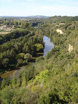
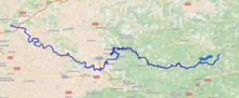
The Agout or Agoût (French pronunciation: [aɡu]; Occitan: Agot) is a 194.4-kilometre (120.8 mi) long river in south-western France. It is a left tributary of the Tarn.[1] Its source is in the southern Massif Central, in the Haut-Languedoc Regional Nature Park. It flows generally west through the following department and towns:
- Hérault: La Salvetat-sur-Agout
- Tarn: Brassac, Castres, Lavaur, Saint-Sulpice
The Agout flows into the Tarn at Saint-Sulpice.
Among its tributaries are the Dadou, the Gijou and the Thoré.


References
Wikimedia Commons has media related to Agout.
Authority control databases | |
|---|---|
| International |
|
| National |
|
- v
- t
- e
This article related to a river in France is a stub. You can help Wikipedia by expanding it. |
- v
- t
- e


