Allery
Commune in Hauts-de-France, France
Commune in Hauts-de-France, France

Coat of arms
Location of Allery

(2020–2026) François Quignon[1]
1
(2021)[2]
80019 /80270
(avg. 28 m or 92 ft)
Allery (French pronunciation: [alʁi]) is a commune in the Somme department in Hauts-de-France in northern France.
Geography
The commune is situated 25 km (16 mi) south of Abbeville, at the junction of the D193 and D76 roads.
Population
| Year | Pop. | ±% p.a. |
|---|---|---|
| 1968 | 911 | — |
| 1975 | 863 | −0.77% |
| 1982 | 790 | −1.25% |
| 1990 | 736 | −0.88% |
| 1999 | 752 | +0.24% |
| 2007 | 760 | +0.13% |
| 2012 | 806 | +1.18% |
| 2017 | 793 | −0.32% |
| Source: INSEE[3] | ||
Places and monuments
- War Memorial
- twelfth century church
See also
Communes of the Somme department
References
- ^ "Répertoire national des élus: les maires". data.gouv.fr, Plateforme ouverte des données publiques françaises (in French). 9 August 2021.
- ^ "Populations légales 2021". The National Institute of Statistics and Economic Studies. 28 December 2023.
- ^ Population en historique depuis 1968, INSEE
Wikimedia Commons has media related to Allery.
-
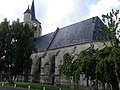 Around the church
 -
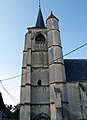 The bell-tower and external staircase
 -
 Fleur de lys decoration on the stained-glass
 -
 The bell-tower


- v
- t
- e
Communes of the Somme department
- Abbevillesubpr
- Ablaincourt-Pressoir
- Acheux-en-Amiénois
- Acheux-en-Vimeu
- Agenville
- Agenvillers
- Aigneville
- Ailly-le-Haut-Clocher
- Ailly-sur-Noye
- Ailly-sur-Somme
- Airaines
- Aizecourt-le-Bas
- Aizecourt-le-Haut
- Albert
- Allaines
- Allenay
- Allery
- Allonville
- Amienspref
- Andainville
- Andechy
- Argœuves
- Argoules
- Arguel
- Armancourt
- Arquèves
- Arrest
- Arry
- Arvillers
- Assainvillers
- Assevillers
- Athies
- Aubercourt
- Aubigny
- Aubvillers
- Auchonvillers
- Ault
- Aumâtre
- Aumont
- Autheux
- Authie
- Authieule
- Authuille
- Avelesges
- Aveluy
- Avesnes-Chaussoy
- Ayencourt
- Bacouel-sur-Selle
- Bailleul
- Baizieux
- Balâtre
- Barleux
- Barly
- Bavelincourt
- Bayencourt
- Bayonvillers
- Bazentin
- Béalcourt
- Beaucamps-le-Jeune
- Beaucamps-le-Vieux
- Beauchamps
- Beaucourt-en-Santerre
- Beaucourt-sur-l'Ancre
- Beaucourt-sur-l'Hallue
- Beaufort-en-Santerre
- Beaumetz
- Beaumont-Hamel
- Beauquesne
- Beauval
- Bécordel-Bécourt
- Becquigny
- Béhen
- Béhencourt
- Bellancourt
- Belleuse
- Belloy-en-Santerre
- Belloy-Saint-Léonard
- Belloy-sur-Somme
- Bergicourt
- Bermesnil
- Bernâtre
- Bernaville
- Bernay-en-Ponthieu
- Bernes
- Berneuil
- Berny-en-Santerre
- Bertangles
- Berteaucourt-les-Dames
- Berteaucourt-lès-Thennes
- Bertrancourt
- Béthencourt-sur-Mer
- Béthencourt-sur-Somme
- Bettembos
- Bettencourt-Rivière
- Bettencourt-Saint-Ouen
- Beuvraignes
- Biaches
- Biarre
- Biencourt
- Billancourt
- Blangy-sous-Poix
- Blangy-Tronville
- Boisbergues
- Le Boisle
- Boismont
- Bonnay
- Bonneville
- Bosquel
- Bouchavesnes-Bergen
- Bouchoir
- Bouchon
- Boufflers
- Bougainville
- Bouillancourt-en-Séry
- Bouillancourt-la-Bataille
- Bouquemaison
- Bourdon
- Bourseville
- Boussicourt
- Bouttencourt
- Bouvaincourt-sur-Bresle
- Bouvincourt-en-Vermandois
- Bouzincourt
- Bovelles
- Boves
- Braches
- Brailly-Cornehotte
- Brassy
- Bray-lès-Mareuil
- Bray-sur-Somme
- Breilly
- Bresle
- Breuil
- Brévillers
- Brie
- Briquemesnil-Floxicourt
- Brocourt
- Brouchy
- Brucamps
- Brutelles
- Buigny-l'Abbé
- Buigny-lès-Gamaches
- Buigny-Saint-Maclou
- Buire-Courcelles
- Buire-sur-l'Ancre
- Bus-la-Mésière
- Bus-lès-Artois
- Bussu
- Bussus-Bussuel
- Bussy-lès-Daours
- Bussy-lès-Poix
- Buverchy
- Cachy
- Cagny
- Cahon
- Caix
- Cambron
- Camon
- Camps-en-Amiénois
- Canaples
- Canchy
- Candas
- Cannessières
- Cantigny
- Caours
- Cappy
- Cardonnette
- Le Cardonnois
- Carnoy-Mametz
- Carrépuis
- Cartigny
- Caulières
- Cavillon
- Cayeux-en-Santerre
- Cayeux-sur-Mer
- Cerisy
- Cerisy-Buleux
- Champien
- Chaulnes
- La Chaussée-Tirancourt
- Chaussoy-Epagny
- La Chavatte
- Chépy
- Chilly
- Chipilly
- Chirmont
- Chuignes
- Chuignolles
- Citerne
- Cizancourt
- Clairy-Saulchoix
- Cléry-sur-Somme
- Cocquerel
- Coigneux
- Coisy
- Colincamps
- Combles
- Condé-Folie
- Contalmaison
- Contay
- Conteville
- Contre
- Conty
- Corbie
- Cottenchy
- Coullemelle
- Coulonvillers
- Courcelette
- Courcelles-au-Bois
- Courcelles-sous-Moyencourt
- Courcelles-sous-Thoix
- Courtemanche
- Cramont
- Crécy-en-Ponthieu
- Crémery
- Cressy-Omencourt
- Creuse
- Croix-Moligneaux
- Croixrault
- Le Crotoy
- Crouy-Saint-Pierre
- Curchy
- Curlu
- Damery
- Dancourt-Popincourt
- Daours
- Dargnies
- Davenescourt
- Démuin
- Dernancourt
- Devise
- Doingt
- Domart-en-Ponthieu
- Domart-sur-la-Luce
- Domesmont
- Dominois
- Domléger-Longvillers
- Dommartin
- Dompierre-Becquincourt
- Dompierre-sur-Authie
- Domqueur
- Domvast
- Doudelainville
- Douilly
- Doullens
- Dreuil-lès-Amiens
- Driencourt
- Dromesnil
- Drucat
- Dury
- Eaucourt-sur-Somme
- L'Échelle-Saint-Aurin
- Éclusier-Vaux
- Embreville
- Englebelmer
- Ennemain
- Épagne-Épagnette
- Épaumesnil
- Épécamps
- Épehy
- Épénancourt
- Éplessier
- Eppeville
- Équancourt
- Équennes-Éramecourt
- Erches
- Ercheu
- Ercourt
- Ergnies
- Érondelle
- Esclainvillers
- Esmery-Hallon
- Essertaux
- Estrébœuf
- Estrées-Deniécourt
- Estrées-lès-Crécy
- Estrées-Mons
- Estrées-sur-Noye
- Étalon
- Ételfay
- Éterpigny
- Étinehem-Méricourt
- L'Étoile
- Étréjust
- Étricourt-Manancourt
- La Faloise
- Falvy
- Famechon
- Faverolles
- Favières
- Fay
- Ferrières
- Fescamps
- Feuillères
- Feuquières-en-Vimeu
- Fieffes-Montrelet
- Fienvillers
- Fignières
- Fins
- Flaucourt
- Flers
- Flers-sur-Noye
- Flesselles
- Fleury
- Flixecourt
- Fluy
- Folies
- Folleville
- Fonches-Fonchette
- Fontaine-le-Sec
- Fontaine-lès-Cappy
- Fontaine-sous-Montdidier
- Fontaine-sur-Maye
- Fontaine-sur-Somme
- Forceville
- Forceville-en-Vimeu
- Forest-l'Abbaye
- Forest-Montiers
- Fort-Mahon-Plage
- Fossemanant
- Foucaucourt-en-Santerre
- Foucaucourt-Hors-Nesle
- Fouencamps
- Fouilloy
- Fouquescourt
- Fourcigny
- Fourdrinoy
- Framerville-Rainecourt
- Framicourt
- Francières
- Franleu
- Franqueville
- Fransart
- Fransu
- Fransures
- Franvillers
- Fréchencourt
- Frémontiers
- Fresnes-Mazancourt
- Fresnes-Tilloloy
- Fresneville
- Fresnoy-Andainville
- Fresnoy-au-Val
- Fresnoy-en-Chaussée
- Fresnoy-lès-Roye
- Fressenneville
- Frettecuisse
- Frettemeule
- Friaucourt
- Fricamps
- Fricourt
- Frise
- Friville-Escarbotin
- Frohen-sur-Authie
- Froyelles
- Frucourt
- Gamaches
- Gapennes
- Gauville
- Gentelles
- Gézaincourt
- Ginchy
- Glisy
- Gorenflos
- Gorges
- Goyencourt
- Grandcourt
- Grand-Laviers
- Gratibus
- Grattepanche
- Grébault-Mesnil
- Grivesnes
- Grivillers
- Grouches-Luchuel
- Gruny
- Guerbigny
- Gueschart
- Gueudecourt
- Guignemicourt
- Guillaucourt
- Guillemont
- Guizancourt
- Guyencourt-Saulcourt
- Guyencourt-sur-Noye
- Hailles
- Hallencourt
- Hallivillers
- Halloy-lès-Pernois
- Hallu
- Ham
- Le Hamel
- Hamelet
- Hancourt
- Hangard
- Hangest-en-Santerre
- Hangest-sur-Somme
- Harbonnières
- Hardecourt-aux-Bois
- Harponville
- Hattencourt
- Hautvillers-Ouville
- Havernas
- Hébécourt
- Hédauville
- Heilly
- Hem-Hardinval
- Hem-Monacu
- Hénencourt
- Herbécourt
- Hérissart
- Herleville
- Herly
- Hervilly
- Hesbécourt
- Hescamps
- Heucourt-Croquoison
- Heudicourt
- Heuzecourt
- Hiermont
- Hombleux
- Hornoy-le-Bourg
- Huchenneville
- Humbercourt
- Huppy
- Hypercourt
- Ignaucourt
- Inval-Boiron
- Irles
- Jumel
- Laboissière-en-Santerre
- Lachapelle
- Lafresguimont-Saint-Martin
- Lahoussoye
- Laleu
- Lamaronde
- Lamotte-Brebière
- Lamotte-Buleux
- Lamotte-Warfusée
- Lanchères
- Lanches-Saint-Hilaire
- Languevoisin-Quiquery
- Laucourt
- Laviéville
- Lawarde-Mauger-l'Hortoy
- Léalvillers
- Lesbœufs
- Liancourt-Fosse
- Licourt
- Liéramont
- Liercourt
- Ligescourt
- Lignières
- Lignières-Châtelain
- Lignières-en-Vimeu
- Lihons
- Limeux
- Liomer
- Long
- Longavesnes
- Longpré-les-Corps-Saints
- Longueau
- Longueval
- Longuevillette
- Louvencourt
- Louvrechy
- Lucheux
- Machiel
- Machy
- Mailly-Maillet
- Mailly-Raineval
- Maisnières
- Maison-Ponthieu
- Maison-Roland
- Maizicourt
- Malpart
- Marcelcave
- Marché-Allouarde
- Marchélepot-Misery
- Marestmontiers
- Mareuil-Caubert
- Maricourt
- Marieux
- Marlers
- Marquaix
- Marquivillers
- Martainneville
- Matigny
- Maucourt
- Maurepas
- Le Mazis
- Méaulte
- Méharicourt
- Meigneux
- Le Meillard
- Méneslies
- Méréaucourt
- Mérélessart
- Méricourt-en-Vimeu
- Méricourt-l'Abbé
- Mers-les-Bains
- Le Mesge
- Mesnil-Bruntel
- Mesnil-Domqueur
- Mesnil-en-Arrouaise
- Mesnil-Martinsart
- Mesnil-Saint-Georges
- Mesnil-Saint-Nicaise
- Métigny
- Mézerolles
- Mézières-en-Santerre
- Miannay
- Millencourt
- Millencourt-en-Ponthieu
- Miraumont
- Mirvaux
- Moislains
- Molliens-au-Bois
- Molliens-Dreuil
- Monchy-Lagache
- Mons-Boubert
- Monsures
- Montagne-Fayel
- Montauban-de-Picardie
- Montdidiersubpr
- Montigny-les-Jongleurs
- Montigny-sur-l'Hallue
- Montonvillers
- Morchain
- Morcourt
- Moreuil
- Morisel
- Morlancourt
- Morvillers-Saint-Saturnin
- Mouflers
- Mouflières
- Moyencourt
- Moyencourt-lès-Poix
- Moyenneville
- Muille-Villette
- Nampont
- Namps-Maisnil
- Nampty
- Naours
- Nesle
- Nesle-l'Hôpital
- Neslette
- Neufmoulin
- Neuilly-le-Dien
- Neuilly-l'Hôpital
- Neuville-au-Bois
- Neuville-Coppegueule
- La Neuville-lès-Bray
- La Neuville-Sire-Bernard
- Neuvillette
- Nibas
- Nouvion
- Noyelles-en-Chaussée
- Noyelles-sur-Mer
- Nurlu
- Occoches
- Ochancourt
- Ô-de-Selle
- Offignies
- Offoy
- Oisemont
- Oissy
- Oneux
- Oresmaux
- Oust-Marest
- Outrebois
- Ovillers-la-Boisselle
- Pargny
- Parvillers-le-Quesnoy
- Pendé
- Pernois
- Péronnesubpr
- Picquigny
- Piennes-Onvillers
- Pierregot
- Pissy
- Plachy-Buyon
- Le Plessier-Rozainvillers
- Pœuilly
- Poix-de-Picardie
- Ponches-Estruval
- Pont-de-Metz
- Ponthoile
- Pont-Noyelles
- Pont-Remy
- Port-le-Grand
- Potte
- Poulainville
- Pozières
- Prouville
- Prouzel
- Proyart
- Puchevillers
- Punchy
- Puzeaux
- Pys
- Quend
- Querrieu
- Le Quesne
- Le Quesnel
- Quesnoy-le-Montant
- Quesnoy-sur-Airaines
- Quevauvillers
- Quiry-le-Sec
- Quivières
- Raincheval
- Rainneville
- Ramburelles
- Rambures
- Rancourt
- Regnière-Écluse
- Remaisnil
- Remaugies
- Remiencourt
- Rethonvillers
- Revelles
- Ribeaucourt
- Ribemont-sur-Ancre
- Riencourt
- Rivery
- Rogy
- Roiglise
- Roisel
- Rollot
- Ronssoy
- Rosières-en-Santerre
- Rouvrel
- Rouvroy-en-Santerre
- Rouy-le-Grand
- Rouy-le-Petit
- Roye
- Rubempré
- Rubescourt
- Rue
- Rumigny
- Saigneville
- Sailly-Flibeaucourt
- Sailly-Laurette
- Sailly-le-Sec
- Sailly-Saillisel
- Sains-en-Amiénois
- Saint-Acheul
- Saint-Aubin-Montenoy
- Saint-Aubin-Rivière
- Saint-Blimont
- Saint-Christ-Briost
- Sainte-Segrée
- Saint-Fuscien
- Saint-Germain-sur-Bresle
- Saint-Gratien
- Saint-Léger-lès-Authie
- Saint-Léger-lès-Domart
- Saint-Léger-sur-Bresle
- Saint-Mard
- Saint-Maulvis
- Saint-Maxent
- Saint-Ouen
- Saint-Quentin-en-Tourmont
- Saint-Quentin-la-Motte-Croix-au-Bailly
- Saint-Riquier
- Saint-Sauflieu
- Saint-Sauveur
- Saint-Vaast-en-Chaussée
- Saint-Valery-sur-Somme
- Saisseval
- Saleux
- Salouël
- Sancourt
- Saulchoy-sous-Poix
- Sauvillers-Mongival
- Saveuse
- Senarpont
- Senlis-le-Sec
- Sentelie
- Seux
- Sorel
- Sorel-en-Vimeu
- Soues
- Sourdon
- Soyécourt
- Surcamps
- Suzanne
- Tailly
- Talmas
- Templeux-la-Fosse
- Templeux-le-Guérard
- Terramesnil
- Tertry
- Thennes
- Thézy-Glimont
- Thiepval
- Thieulloy-l'Abbaye
- Thieulloy-la-Ville
- Thièvres
- Thoix
- Thory
- Tilloloy
- Tilloy-Floriville
- Tincourt-Boucly
- Le Titre
- Tœufles
- Tours-en-Vimeu
- Toutencourt
- Le Translay
- Treux
- Trois-Rivières
- Tully
- Ugny-l'Équipée
- Vadencourt
- Vaire-sous-Corbie
- Valines
- Varennes
- Vauchelles-lès-Authie
- Vauchelles-lès-Domart
- Vauchelles-les-Quesnoy
- Vaudricourt
- Vauvillers
- Vaux-en-Amiénois
- Vaux-Marquenneville
- Vaux-sur-Somme
- Vecquemont
- Velennes
- Vercourt
- Vergies
- Vermandovillers
- Verpillières
- Vers-sur-Selle
- La Vicogne
- Vignacourt
- Villecourt
- Ville-le-Marclet
- Villeroy
- Villers-aux-Érables
- Villers-Bocage
- Villers-Bretonneux
- Villers-Campsart
- Villers-Carbonnel
- Villers-Faucon
- Villers-lès-Roye
- Villers-sous-Ailly
- Villers-sur-Authie
- Villers-Tournelle
- Ville-sur-Ancre
- Vironchaux
- Vismes
- Vitz-sur-Authie
- Voyennes
- Vraignes-en-Vermandois
- Vraignes-lès-Hornoy
- Vrély
- Vron
- Wargnies
- Warloy-Baillon
- Warlus
- Warsy
- Warvillers
- Wiencourt-l'Équipée
- Wiry-au-Mont
- Woignarue
- Woincourt
- Woirel
- Y
- Yaucourt-Bussus
- Yonval
- Yvrench
- Yvrencheux
- Yzengremer
- Yzeux
- pref: prefecture
- subpr: subprefecture
Authority control databases | |
|---|---|
| International |
|
| National |
|
This Arrondissement of Abbeville geographical article is a stub. You can help Wikipedia by expanding it. |
- v
- t
- e


