Avelanges
Commune in Bourgogne-Franche-Comté, France

Coat of arms
Location of Avelanges

(2020–2026) Sylvain Rebérol[1]
1
(2021)[2]
21039 /21120
(avg. 370 m or 1,210 ft)
Avelanges (French pronunciation: [avlɑ̃ʒ]) is a commune in the Côte-d'Or department in the Bourgogne-Franche-Comté region of eastern France.
Geography
Avelanges is located some 45 km north of Dijon and 35 km east by south-east of Aignay-le-Duc. Access to the commune is by the D120 road which branches from the D112 south of Avot in the north and passes through the commune and village before continuing south-west to Marey-sur-Tille. The commune has extensive forests mixed with smaller areas of farmland.[3]
Neighbouring communes and villages
Places adjacent to Avelanges | ||||||||||||||||
|---|---|---|---|---|---|---|---|---|---|---|---|---|---|---|---|---|
| ||||||||||||||||


Toponymy
The name was Arclenglis or Avelengiis in 1028, Avallangiae in 1244, and Avelanges in 1793.
Administration

This list is incomplete; you can help by adding missing items. (April 2021) |
List of Successive Mayors[4]
| From | To | Name |
|---|---|---|
| 2001 | 2020 | Jean Michel Moyemont |
| 2020 | 2026 | Sylvain Rebérol |
Demography

The inhabitants of the commune are known as Avelangeais or Avelangeaises in French.[5]
|
| ||||||||||||||||||||||||||||||||||||||||||||||||||||||||||||||||||||||||||||||||||||||||||||||||||||||||||||||||||
| Source: EHESS[6] and INSEE[7] | |||||||||||||||||||||||||||||||||||||||||||||||||||||||||||||||||||||||||||||||||||||||||||||||||||||||||||||||||||
Avelanges Picture Gallery
-
 Avelanges School
 -
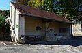 Avelanges Lavoir (Public Laundry)
 -
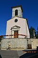 Avelanges Church
 -
 A Water Trough in Avalanges


See also
References
- ^ "Répertoire national des élus: les maires". data.gouv.fr, Plateforme ouverte des données publiques françaises (in French). 2 December 2020.
- ^ "Populations légales 2021". The National Institute of Statistics and Economic Studies. 28 December 2023.
- ^ a b Google Maps
- ^ List of Mayors of France (in French)
- ^ Le nom des habitants du 21 - Côte-d'Or, habitants.fr
- ^ Des villages de Cassini aux communes d'aujourd'hui: Commune data sheet Avelanges, EHESS (in French).
- ^ Population en historique depuis 1968, INSEE
External links
- Avelanges on Géoportail, National Geographic Institute (IGN) website (in French)
- Avelanges on the 1750 Cassini Map
Wikimedia Commons has media related to Avelanges.
- v
- t
- e

- Agencourt
- Agey
- Ahuy
- Aignay-le-Duc
- Aiserey
- Aisey-sur-Seine
- Aisy-sous-Thil
- Alise-Sainte-Reine
- Allerey
- Aloxe-Corton
- Ampilly-les-Bordes
- Ampilly-le-Sec
- Ancey
- Antheuil
- Antigny-la-Ville
- Arceau
- Arcenant
- Arcey
- Arconcey
- Arc-sur-Tille
- Argilly
- Arnay-le-Duc
- Arnay-sous-Vitteaux
- Arrans
- Asnières-en-Montagne
- Asnières-lès-Dijon
- Athée
- Athie
- Aubaine
- Aubigny-en-Plaine
- Aubigny-la-Ronce
- Aubigny-lès-Sombernon
- Autricourt
- Auvillars-sur-Saône
- Auxant
- Auxey-Duresses
- Auxonne
- Avelanges
- Avosnes
- Avot
- Bagnot
- Baigneux-les-Juifs
- Balot
- Barbirey-sur-Ouche
- Bard-le-Régulier
- Bard-lès-Époisses
- Barges
- Barjon
- Baubigny
- Baulme-la-Roche
- Beaulieu
- Beaumont-sur-Vingeanne
- Beaunesubpr
- Beaunotte
- Beire-le-Châtel
- Beire-le-Fort
- Belan-sur-Ource
- Bellefond
- Belleneuve
- Bellenod-sur-Seine
- Bellenot-sous-Pouilly
- Beneuvre
- Benoisey
- Bessey-en-Chaume
- Bessey-la-Cour
- Bessey-lès-Cîteaux
- Beurey-Bauguay
- Beurizot
- Bévy
- Bèze
- Bézouotte
- Billey
- Billy-lès-Chanceaux
- Binges
- Bissey-la-Côte
- Bissey-la-Pierre
- Blagny-sur-Vingeanne
- Blaisy-Bas
- Blaisy-Haut
- Blancey
- Blanot
- Bligny-lès-Beaune
- Bligny-le-Sec
- Bligny-sur-Ouche
- Boncourt-le-Bois
- Bonnencontre
- Boudreville
- Bouhey
- Bouilland
- Bouix
- Bourberain
- Bousselange
- Boussenois
- Boussey
- Boux-sous-Salmaise
- Bouze-lès-Beaune
- Brain
- Braux
- Brazey-en-Morvan
- Brazey-en-Plaine
- Brémur-et-Vaurois
- Bressey-sur-Tille
- Bretenière
- Bretigny
- Brianny
- Brion-sur-Ource
- Brochon
- Brognon
- Broin
- Broindon
- Buffon
- Buncey
- Bure-les-Templiers
- Busseaut
- Busserotte-et-Montenaille
- Bussières
- La Bussière-sur-Ouche
- Bussy-la-Pesle
- Bussy-le-Grand
- Buxerolles
- Censerey
- Cérilly
- Cessey-sur-Tille
- Chaignay
- Chailly-sur-Armançon
- Chambain
- Chambeire
- Chamblanc
- Chambœuf
- Chambolle-Musigny
- Chamesson
- Champagne-sur-Vingeanne
- Champagny
- Champ-d'Oiseau
- Champdôtre
- Champeau-en-Morvan
- Champignolles
- Champrenault
- Chanceaux
- Channay
- Charencey
- Charigny
- Charmes
- Charny
- Charrey-sur-Saône
- Charrey-sur-Seine
- Chassagne-Montrachet
- Chassey
- Châteauneuf
- Châtellenot
- Châtillon-sur-Seine
- Chaudenay-la-Ville
- Chaudenay-le-Château
- Chaugey
- La Chaume
- Chaume-et-Courchamp
- Chaume-lès-Baigneux
- Chaumont-le-Bois
- Chaux
- Chazeuil
- Chazilly
- Chemin-d'Aisey
- Chenôve
- Cheuge
- Chevannay
- Chevannes
- Chevigny-en-Valière
- Chevigny-Saint-Sauveur
- Chivres
- Chorey-les-Beaune
- Cirey-lès-Pontailler
- Civry-en-Montagne
- Clamerey
- Clénay
- Cléry
- Clomot
- Collonges-et-Premières
- Collonges-lès-Bévy
- Colombier
- Combertault
- Comblanchien
- Commarin
- Corberon
- Corcelles-les-Arts
- Corcelles-lès-Cîteaux
- Corcelles-les-Monts
- Corgengoux
- Corgoloin
- Cormot-Vauchignon
- Corpeau
- Corpoyer-la-Chapelle
- Corrombles
- Corsaint
- Couchey
- Coulmier-le-Sec
- Courban
- Courcelles-Frémoy
- Courcelles-lès-Montbard
- Courcelles-lès-Semur
- Courlon
- Courtivron
- Couternon
- Créancey
- Crécey-sur-Tille
- Crépand
- Crugey
- Cuiserey
- Culètre
- Curley
- Curtil-Saint-Seine
- Curtil-Vergy
- Cussey-les-Forges
- Cussy-la-Colonne
- Cussy-le-Châtel
- Daix
- Dampierre-en-Montagne
- Dampierre-et-Flée
- Darcey
- Darois
- Détain-et-Bruant
- Diancey
- Diénay
- Dijonpref
- Dompierre-en-Morvan
- Drambon
- Drée
- Duesme
- Ébaty
- Échalot
- Échannay
- Échenon
- Échevannes
- Échevronne
- Échigey
- Écutigny
- Éguilly
- Épagny
- Épernay-sous-Gevrey
- Époisses
- Éringes
- Esbarres
- Essarois
- Essey
- Étais
- Étalante
- L'Étang-Vergy
- Étaules
- Étevaux
- Étormay
- Étrochey
- Fain-lès-Montbard
- Fain-lès-Moutiers
- Fauverney
- Faverolles-lès-Lucey
- Fénay
- Le Fête
- Fixin
- Flacey
- Flagey-Echézeaux
- Flagey-lès-Auxonne
- Flammerans
- Flavignerot
- Flavigny-sur-Ozerain
- Fleurey-sur-Ouche
- Foissy
- Foncegrive
- Fontaine-Française
- Fontaine-lès-Dijon
- Fontaines-en-Duesmois
- Fontaines-les-Sèches
- Fontangy
- Fontenelle
- Forléans
- Fraignot-et-Vesvrotte
- Francheville
- Franxault
- Frénois
- Fresnes
- Frôlois
- Fussey
- Gemeaux
- Genay
- Genlis
- Gergueil
- Gerland
- Gevrey-Chambertin
- Gevrolles
- Gilly-lès-Cîteaux
- Gissey-le-Vieil
- Gissey-sous-Flavigny
- Gissey-sur-Ouche
- Glanon
- Gomméville
- Les Goulles
- Grancey-le-Château-Neuvelle
- Grancey-sur-Ource
- Grenant-lès-Sombernon
- Grésigny-Sainte-Reine
- Grignon
- Griselles
- Grosbois-en-Montagne
- Grosbois-lès-Tichey
- Gurgy-la-Ville
- Gurgy-le-Château
- Hauteroche
- Hauteville-lès-Dijon
- Heuilley-sur-Saône
- Is-sur-Tille
- Izeure
- Izier
- Jailly-les-Moulins
- Jallanges
- Jancigny
- Jeux-lès-Bard
- Jouey
- Jours-lès-Baigneux
- Juillenay
- Juilly
- Labergement-Foigney
- Labergement-lès-Auxonne
- Labergement-lès-Seurre
- Labruyère
- Lacanche
- Lacour-d'Arcenay
- Ladoix-Serrigny
- Laignes
- Lamarche-sur-Saône
- Lamargelle
- Lantenay
- Lanthes
- Lantilly
- Laperrière-sur-Saône
- Larrey
- Lechâtelet
- Léry
- Leuglay
- Levernois
- Licey-sur-Vingeanne
- Liernais
- Lignerolles
- Longchamp
- Longeault-Pluvault
- Longecourt-en-Plaine
- Longecourt-lès-Culêtre
- Longvic
- Losne
- Louesme
- Lucenay-le-Duc
- Lucey
- Lusigny-sur-Ouche
- Lux
- Maconge
- Magnien
- Magny-Lambert
- Magny-la-Ville
- Magny-lès-Aubigny
- Magny-lès-Villers
- Magny-Montarlot
- Magny-Saint-Médard
- Magny-sur-Tille
- Les Maillys
- Maisey-le-Duc
- Mâlain
- Maligny
- Manlay
- Marandeuil
- Marcellois
- Marcenay
- Marcheseuil
- Marcigny-sous-Thil
- Marcilly-et-Dracy
- Marcilly-Ogny
- Marcilly-sur-Tille
- Marey-lès-Fussey
- Marey-sur-Tille
- Marigny-le-Cahouët
- Marigny-lès-Reullée
- Marliens
- Marmagne
- Marsannay-la-Côte
- Marsannay-le-Bois
- Martrois
- Massingy
- Massingy-lès-Semur
- Massingy-lès-Vitteaux
- Mauvilly
- Mavilly-Mandelot
- Maxilly-sur-Saône
- Meilly-sur-Rouvres
- Le Meix
- Meloisey
- Menesble
- Ménessaire
- Ménétreux-le-Pitois
- Merceuil
- Mesmont
- Messanges
- Messigny-et-Vantoux
- Meuilley
- Meulson
- Meursanges
- Meursault
- Millery
- Mimeure
- Minot
- Mirebeau-sur-Bèze
- Missery
- Moitron
- Molesme
- Molinot
- Moloy
- Molphey
- Montagny-lès-Beaune
- Montagny-lès-Seurre
- Montbardsubpr
- Montberthault
- Montceau-et-Écharnant
- Monthelie
- Montigny-Montfort
- Montigny-Mornay-Villeneuve-sur-Vingeanne
- Montigny-Saint-Barthélemy
- Montigny-sur-Armançon
- Montigny-sur-Aube
- Montlay-en-Auxois
- Montliot-et-Courcelles
- Montmain
- Montmançon
- Montmoyen
- Montoillot
- Montot
- Mont-Saint-Jean
- Morey-Saint-Denis
- Mosson
- La Motte-Ternant
- Moutiers-Saint-Jean
- Musigny
- Mussy-la-Fosse
- Nan-sous-Thil
- Nantoux
- Nesle-et-Massoult
- Neuilly-Crimolois
- Nicey
- Nod-sur-Seine
- Nogent-lès-Montbard
- Noidan
- Noiron-sous-Gevrey
- Noiron-sur-Bèze
- Noiron-sur-Seine
- Nolay
- Norges-la-Ville
- Normier
- Nuits-Saint-Georges
- Obtrée
- Oigny
- Oisilly
- Orain
- Orgeux
- Origny
- Orret
- Orville
- Ouges
- Pagny-la-Ville
- Pagny-le-Château
- Painblanc
- Panges
- Pasques
- Pellerey
- Pernand-Vergelesses
- Perrigny-lès-Dijon
- Perrigny-sur-l'Ognon
- Pichanges
- Planay
- Plombières-lès-Dijon
- Pluvet
- Poinçon-lès-Larrey
- Poiseul-la-Grange
- Poiseul-la-Ville-et-Laperrière
- Poiseul-lès-Saulx
- Pommard
- Poncey-lès-Athée
- Poncey-sur-l'Ignon
- Pont
- Pont-et-Massène
- Pontailler-sur-Saône
- Posanges
- Pothières
- Pouillenay
- Pouilly-en-Auxois
- Pouilly-sur-Saône
- Pouilly-sur-Vingeanne
- Prâlon
- Précy-sous-Thil
- Premeaux-Prissey
- Prenois
- Prusly-sur-Ource
- Puits
- Puligny-Montrachet
- Quemigny-sur-Seine
- Quetigny
- Quincerot
- Quincey
- Quincy-le-Vicomte
- Recey-sur-Ource
- Remilly-en-Montagne
- Remilly-sur-Tille
- Renève
- Reulle-Vergy
- Riel-les-Eaux
- La Roche-en-Brenil
- Rochefort-sur-Brévon
- La Rochepot
- La Roche-Vanneau
- Roilly
- Rougemont
- Rouvray
- Rouvres-en-Plaine
- Rouvres-sous-Meilly
- Ruffey-lès-Beaune
- Ruffey-lès-Echirey
- Sacquenay
- Saffres
- Saint-Andeux
- Saint-Anthot
- Saint-Apollinaire
- Saint-Aubin
- Saint-Bernard
- Saint-Broing-les-Moines
- Saint-Didier
- Sainte-Colombe-en-Auxois
- Sainte-Colombe-sur-Seine
- Sainte-Marie-la-Blanche
- Sainte-Marie-sur-Ouche
- Sainte-Sabine
- Saint-Euphrône
- Saint-Germain-de-Modéon
- Saint-Germain-le-Rocheux
- Saint-Germain-lès-Senailly
- Saint-Hélier
- Saint-Jean-de-Bœuf
- Saint-Jean-de-Losne
- Saint-Julien
- Saint-Léger-Triey
- Saint-Marc-sur-Seine
- Saint-Martin-de-la-Mer
- Saint-Martin-du-Mont
- Saint-Maurice-sur-Vingeanne
- Saint-Mesmin
- Saint-Nicolas-lès-Cîteaux
- Saint-Philibert
- Saint-Pierre-en-Vaux
- Saint-Prix-lès-Arnay
- Saint-Rémy
- Saint-Romain
- Saint-Sauveur
- Saint-Seine-en-Bâche
- Saint-Seine-l'Abbaye
- Saint-Seine-sur-Vingeanne
- Saint-Symphorien-sur-Saône
- Saint-Thibault
- Saint-Usage
- Saint-Victor-sur-Ouche
- Salives
- Salmaise
- Samerey
- Santenay
- Santosse
- Saulieu
- Saulon-la-Chapelle
- Saulon-la-Rue
- Saulx-le-Duc
- Saussey
- Saussy
- Savigny-lès-Beaune
- Savigny-le-Sec
- Savigny-sous-Mâlain
- Savilly
- Savoisy
- Savolles
- Savouges
- Segrois
- Seigny
- Selongey
- Semarey
- Semezanges
- Semond
- Semur-en-Auxois
- Senailly
- Sennecey-lès-Dijon
- Seurre
- Sincey-lès-Rouvray
- Soirans
- Soissons-sur-Nacey
- Sombernon
- Souhey
- Source-Seine
- Soussey-sur-Brionne
- Spoy
- Sussey
- Tailly
- Talant
- Talmay
- Tanay
- Tarsul
- Tart
- Tart-le-Bas
- Tellecey
- Ternant
- Terrefondrée
- Thenissey
- Thoires
- Thoisy-la-Berchère
- Thoisy-le-Désert
- Thomirey
- Thorey-en-Plaine
- Thorey-sous-Charny
- Thorey-sur-Ouche
- Thoste
- Thury
- Tichey
- Til-Châtel
- Tillenay
- Torcy-et-Pouligny
- Touillon
- Toutry
- Tréclun
- Trochères
- Trouhans
- Trouhaut
- Trugny
- Turcey
- Uncey-le-Franc
- Urcy
- Valforêt
- Le Val-Larrey
- Val-Mont
- Val-Suzon
- Vandenesse-en-Auxois
- Vannaire
- Vanvey
- Varanges
- Varois-et-Chaignot
- Vaux-Saules
- Veilly
- Velars-sur-Ouche
- Velogny
- Venarey-les-Laumes
- Verdonnet
- Vernois-lès-Vesvres
- Vernot
- Véronnes
- Verrey-sous-Drée
- Verrey-sous-Salmaise
- Vertault
- Vesvres
- Veuvey-sur-Ouche
- Veuxhaulles-sur-Aube
- Vianges
- Vic-de-Chassenay
- Vic-des-Prés
- Vic-sous-Thil
- Vieilmoulin
- Vielverge
- Vieux-Château
- Viévigne
- Viévy
- Vignoles
- Villaines-en-Duesmois
- Villaines-les-Prévôtes
- Villargoix
- Villars-et-Villenotte
- Villars-Fontaine
- Villeberny
- Villebichot
- Villecomte
- Villedieu
- Villeferry
- La Villeneuve-les-Convers
- Villeneuve-sous-Charigny
- Villers-la-Faye
- Villers-les-Pots
- Villers-Patras
- Villers-Rotin
- Villey-sur-Tille
- Villiers-en-Morvan
- Villiers-le-Duc
- Villotte-Saint-Seine
- Villotte-sur-Ource
- Villy-en-Auxois
- Villy-le-Moutier
- Viserny
- Vitteaux
- Vix
- Volnay
- Vonges
- Vosne-Romanée
- Voudenay
- Vougeot
- Voulaines-les-Templiers
- pref: prefecture
- subpr: subprefecture
| Authority control databases: National |
|
|---|


