Barenton-Cel
Commune in Hauts-de-France, France
Location of Barenton-Cel

(2020–2026) David Petit[1]
1
(2021)[2]
02047 /02000
Barenton-Cel (French pronunciation: [baʁɑ̃tɔ̃ sɛl]) is a commune in the department of Aisne in the Hauts-de-France region of northern France.
Geography
Barenton-Cel is located some 10 km north by northeast of Laon and 40 km southeast of Saint-Quentin. It can be accessed by the D547 road from Verneuil-sur-Serre in the northeast continuing southwest through the commune and the village to Aulnois-sous-Laon in the southwest. There is also the D545 road from Barenton-Bugny on the southeastern border. The commune consists entirely of farmland with no other villages or hamlets.[3]
The Ru des Barentons stream forms the southeastern border of the commune and flows northeast to join the Souche river in the north.[3]
Neighbouring communes and villages
Places adjacent to Barenton-Cel | ||||||||||||||||
|---|---|---|---|---|---|---|---|---|---|---|---|---|---|---|---|---|
| ||||||||||||||||


Administration
This list is incomplete; you can help by adding missing items. (April 2021) |
List of Successive Mayors of Barenton-Cel[4]
| From | To | Name | Party |
|---|---|---|---|
| 1995 | 2008 | Bernard Brazier | DVD |
| 2008 | Present | David Petit | UMP then LR |
Population
| Year | Pop. | ±% p.a. |
|---|---|---|
| 1968 | 108 | — |
| 1975 | 129 | +2.57% |
| 1982 | 147 | +1.88% |
| 1990 | 141 | −0.52% |
| 1999 | 133 | −0.65% |
| 2007 | 147 | +1.26% |
| 2012 | 133 | −1.98% |
| 2017 | 114 | −3.04% |
| Source: INSEE[5] | ||

- Picture Gallery
-
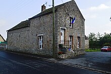
 Barenton-Cel Church
 -
 Plaque on the Church: "The Bell is given in remembrance of the collaboration of the American Red Cross with the Association of Devastated Aisne".
 -
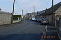 A street in Barenton-Cel
 -
 Barenton-Cel Landscape


See also
References
- ^ "Répertoire national des élus: les maires". data.gouv.fr, Plateforme ouverte des données publiques françaises (in French). 2 December 2020.
- ^ "Populations légales 2021". The National Institute of Statistics and Economic Studies. 28 December 2023.
- ^ a b c Google Maps
- ^ List of Mayors of France (in French)
- ^ Population en historique depuis 1968, INSEE
External links
- Barenton-Cel on the old IGN website (in French)
- Bell Towers website (in French)
- 40000 Bell Towers website (in French)
- Barenton-Cel on Géoportail, National Geographic Institute (IGN) website (in French)
- Baranton Cel on the 1750 Cassini Map
Wikimedia Commons has media related to Barenton-Cel.
- v
- t
- e

- Abbécourt
- Achery
- Acy
- Agnicourt-et-Séchelles
- Aguilcourt
- Aisonville-et-Bernoville
- Aizelles
- Aizy-Jouy
- Alaincourt
- Allemant
- Ambleny
- Ambrief
- Amifontaine
- Amigny-Rouy
- Ancienville
- Andelain
- Anguilcourt-le-Sart
- Anizy-le-Grand
- Annois
- Any-Martin-Rieux
- Archon
- Arcy-Sainte-Restitue
- Armentières-sur-Ourcq
- Arrancy
- Artemps
- Assis-sur-Serre
- Athies-sous-Laon
- Attilly
- Aubencheul-aux-Bois
- Aubenton
- Aubigny-aux-Kaisnes
- Aubigny-en-Laonnois
- Audignicourt
- Audigny
- Augy
- Aulnois-sous-Laon
- Les Autels
- Autremencourt
- Autreppes
- Autreville
- Azy-sur-Marne
- Bagneux
- Bancigny
- Barenton-Bugny
- Barenton-Cel
- Barenton-sur-Serre
- Barisis-aux-Bois
- Barzy-en-Thiérache
- Barzy-sur-Marne
- Bassoles-Aulers
- Bazoches-et-Saint-Thibaut
- Beaumé
- Beaumont-en-Beine
- Beaurevoir
- Beaurieux
- Beautor
- Beauvois-en-Vermandois
- Becquigny
- Belleau
- Bellenglise
- Belleu
- Bellicourt
- Benay
- Bergues-sur-Sambre
- Berlancourt
- Berlise
- Bernot
- Bernoy-le-Château
- Berny-Rivière
- Berrieux
- Berry-au-Bac
- Bertaucourt-Epourdon
- Berthenicourt
- Bertricourt
- Besmé
- Besmont
- Besny-et-Loizy
- Béthancourt-en-Vaux
- Beugneux
- Beuvardes
- Bézu-le-Guéry
- Bézu-Saint-Germain
- Bichancourt
- Bieuxy
- Bièvres
- Billy-sur-Aisne
- Billy-sur-Ourcq
- Blanzy-lès-Fismes
- Blérancourt
- Blesmes
- Bohain-en-Vermandois
- Bois-lès-Pargny
- Boncourt
- Bonneil
- Bonnesvalyn
- Bony
- Bosmont-sur-Serre
- Bouconville-Vauclair
- Boué
- Bouffignereux
- Bouresches
- Bourg-et-Comin
- Bourguignon-sous-Coucy
- Bourguignon-sous-Montbavin
- La Bouteille
- Braine
- Brancourt-en-Laonnois
- Brancourt-le-Grand
- Brasles
- Braye
- Braye-en-Laonnois
- Braye-en-Thiérache
- Bray-Saint-Christophe
- Brécy
- Brenelle
- Breny
- Brie
- Brissay-Choigny
- Brissy-Hamégicourt
- Brumetz
- Brunehamel
- Bruyères-et-Montbérault
- Bruyères-sur-Fère
- Bruys
- Bucilly
- Bucy-le-Long
- Bucy-lès-Cerny
- Bucy-lès-Pierrepont
- Buire
- Buironfosse
- Burelles
- Bussiares
- Buzancy
- Caillouël-Crépigny
- Camelin
- La Capelle
- Castres
- Le Catelet
- Caulaincourt
- Caumont
- Celles-lès-Condé
- Celles-sur-Aisne
- Cerizy
- Cerny-en-Laonnois
- Cerny-lès-Bucy
- Cerseuil
- Cessières-Suzy
- Chacrise
- Chaillevois
- Chalandry
- Chambry
- Chamouille
- Champs
- Chaourse
- La Chapelle-sur-Chézy
- Charly-sur-Marne
- Le Charmel
- Charmes
- Chartèves
- Chassemy
- Château-Thierrysubpr
- Châtillon-lès-Sons
- Châtillon-sur-Oise
- Chaudardes
- Chaudun
- Chauny
- Chavignon
- Chavigny
- Chavonne
- Chérêt
- Chermizy-Ailles
- Chéry-Chartreuve
- Chéry-lès-Pouilly
- Chéry-lès-Rozoy
- Chevennes
- Chevregny
- Chevresis-Monceau
- Chézy-en-Orxois
- Chézy-sur-Marne
- Chierry
- Chigny
- Chivres-en-Laonnois
- Chivres-Val
- Chivy-lès-Étouvelles
- Chouy
- Cierges
- Cilly
- Ciry-Salsogne
- Clacy-et-Thierret
- Clairfontaine
- Clamecy
- Clastres
- Clermont-les-Fermes
- Cœuvres-et-Valsery
- Coincy
- Coingt
- Colligis-Crandelain
- Colonfay
- Commenchon
- Concevreux
- Condé-en-Brie
- Condé-sur-Aisne
- Condé-sur-Suippe
- Condren
- Connigis
- Contescourt
- Corbeny
- Corcy
- Coucy-la-Ville
- Coucy-le-Château-Auffrique
- Coucy-lès-Eppes
- Coulonges-Cohan
- Coupru
- Courbes
- Courboin
- Courcelles-sur-Vesle
- Courchamps
- Courmelles
- Courmont
- Courtemont-Varennes
- Courtrizy-et-Fussigny
- Couvrelles
- Couvron-et-Aumencourt
- Coyolles
- Cramaille
- Craonne
- Craonnelle
- Crécy-au-Mont
- Crécy-sur-Serre
- Crépy
- Crézancy
- Croix-Fonsomme
- La Croix-sur-Ourcq
- Crouttes-sur-Marne
- Crouy
- Crupilly
- Cuffies
- Cugny
- Cuirieux
- Cuiry-Housse
- Cuiry-lès-Chaudardes
- Cuiry-lès-Iviers
- Cuissy-et-Geny
- Cuisy-en-Almont
- Cutry
- Cys-la-Commune
- Dagny-Lambercy
- Dallon
- Dammard
- Dampleux
- Danizy
- Dercy
- Deuillet
- Dhuizel
- Dhuys-et-Morin-en-Brie
- Dizy-le-Gros
- Dohis
- Dolignon
- Dommiers
- Domptin
- Dorengt
- Douchy
- Dravegny
- Droizy
- Dury
- Ébouleau
- Effry
- Englancourt
- Épagny
- Éparcy
- Épaux-Bézu
- Épieds
- L'Épine-aux-Bois
- Eppes
- Erlon
- Erloy
- Esquéhéries
- Essigny-le-Grand
- Essigny-le-Petit
- Essises
- Essômes-sur-Marne
- Estrées
- Étampes-sur-Marne
- Étaves-et-Bocquiaux
- Étouvelles
- Étréaupont
- Étreillers
- Étrépilly
- Étreux
- Évergnicourt
- Faverolles
- Fayet
- La Fère
- Fère-en-Tardenois
- La Ferté-Chevresis
- La Ferté-Milon
- Fesmy-le-Sart
- Festieux
- Fieulaine
- Filain
- La Flamengrie
- Flavigny-le-Grand-et-Beaurain
- Flavy-le-Martel
- Fleury
- Fluquières
- Folembray
- Fonsomme
- Fontaine-lès-Clercs
- Fontaine-lès-Vervins
- Fontaine-Notre-Dame
- Fontaine-Uterte
- Fontenelle
- Fontenoy
- Foreste
- Fossoy
- Fourdrain
- Francilly-Selency
- Franqueville
- Fresnes-en-Tardenois
- Fresnes-sous-Coucy
- Fresnoy-le-Grand
- Fressancourt
- Frières-Faillouël
- Froidestrées
- Froidmont-Cohartille
- Gandelu
- Gauchy
- Gercy
- Gergny
- Germaine
- Gibercourt
- Gizy
- Gland
- Goudelancourt-lès-Berrieux
- Goudelancourt-lès-Pierrepont
- Goussancourt
- Gouy
- Grandlup-et-Fay
- Grandrieux
- Grand-Rozoy
- Grand-Verly
- Gricourt
- Grisolles
- Gronard
- Grougis
- Grugies
- Guise
- Guivry
- Guny
- Guyencourt
- Hannapes
- Happencourt
- Haramont
- Harcigny
- Hargicourt
- Harly
- Hartennes-et-Taux
- Hary
- Hautevesnes
- Hauteville
- Haution
- La Hérie
- Le Hérie-la-Viéville
- Hinacourt
- Hirson
- Holnon
- Homblières
- Houry
- Housset
- Iron
- Itancourt
- Iviers
- Jaulgonne
- Jeancourt
- Jeantes
- Joncourt
- Jouaignes
- Jumencourt
- Jumigny
- Jussy
- Juvigny
- Juvincourt-et-Damary
- Laffaux
- Laigny
- Lanchy
- Landifay-et-Bertaignemont
- Landouzy-la-Cour
- Landouzy-la-Ville
- Landricourt
- Laniscourt
- Laonpref
- Lappion
- Largny-sur-Automne
- Latilly
- Launoy
- Laval-en-Laonnois
- Lavaqueresse
- Laversine
- Lehaucourt
- Lemé
- Lempire
- Lerzy
- Leschelle
- Lesdins
- Lesges
- Lesquielles-Saint-Germain
- Leuilly-sous-Coucy
- Leury
- Leuze
- Levergies
- Lhuys
- Licy-Clignon
- Lierval
- Liesse-Notre-Dame
- Liez
- Limé
- Lislet
- Logny-lès-Aubenton
- Longpont
- Lor
- Louâtre
- Loupeigne
- Lucy-le-Bocage
- Lugny
- Luzoir
- Ly-Fontaine
- Maast-et-Violaine
- Mâchecourt
- Macogny
- Macquigny
- Magny-la-Fosse
- Maissemy
- Maizy
- La Malmaison
- Malzy
- Manicamp
- Marchais
- Marcy
- Marcy-sous-Marle
- Marest-Dampcourt
- Mareuil-en-Dôle
- Marfontaine
- Margival
- Marigny-en-Orxois
- Marizy-Sainte-Geneviève
- Marizy-Saint-Mard
- Marle
- Marly-Gomont
- Martigny
- Martigny-Courpierre
- Mauregny-en-Haye
- Mayot
- Mennessis
- Mennevret
- Mercin-et-Vaux
- Merlieux-et-Fouquerolles
- Mesbrecourt-Richecourt
- Mesnil-Saint-Laurent
- Meurival
- Mézières-sur-Oise
- Mézy-Moulins
- Missy-aux-Bois
- Missy-lès-Pierrepont
- Missy-sur-Aisne
- Molain
- Molinchart
- Monampteuil
- Monceau-le-Neuf-et-Faucouzy
- Monceau-lès-Leups
- Monceau-le-Waast
- Monceau-sur-Oise
- Mondrepuis
- Monnes
- Mons-en-Laonnois
- Montaigu
- Montbavin
- Montbrehain
- Montchâlons
- Montcornet
- Mont-d'Origny
- Montescourt-Lizerolles
- Montfaucon
- Montgobert
- Montgru-Saint-Hilaire
- Monthenault
- Monthiers
- Monthurel
- Montigny-en-Arrouaise
- Montigny-l'Allier
- Montigny-le-Franc
- Montigny-Lengrain
- Montigny-lès-Condé
- Montigny-sous-Marle
- Montigny-sur-Crécy
- Montlevon
- Montloué
- Mont-Notre-Dame
- Montreuil-aux-Lions
- Mont-Saint-Jean
- Mont-Saint-Martin
- Mont-Saint-Père
- Morcourt
- Morgny-en-Thiérache
- Morsain
- Mortefontaine
- Mortiers
- Moulins
- Moussy-Verneuil
- Moÿ-de-l'Aisne
- Muret-et-Crouttes
- Muscourt
- Nampcelles-la-Cour
- Nampteuil-sous-Muret
- Nanteuil-la-Fosse
- Nanteuil-Notre-Dame
- Nauroy
- Nesles-la-Montagne
- Neufchâtel-sur-Aisne
- Neuflieux
- Neuilly-Saint-Front
- Neuve-Maison
- La Neuville-Bosmont
- La Neuville-en-Beine
- La Neuville-Housset
- La Neuville-lès-Dorengt
- Neuville-Saint-Amand
- Neuville-sur-Ailette
- Neuville-sur-Margival
- Neuvillette
- Nizy-le-Comte
- Nogentel
- Nogent-l'Artaud
- Noircourt
- Noroy-sur-Ourcq
- Le Nouvion-en-Thiérache
- Nouvion-et-Catillon
- Nouvion-le-Comte
- Nouvion-le-Vineux
- Nouvron-Vingré
- Noyales
- Œuilly
- Ognes
- Ohis
- Oigny-en-Valois
- Oisy
- Ollezy
- Omissy
- Orainville
- Orgeval
- Origny-en-Thiérache
- Origny-Sainte-Benoite
- Osly-Courtil
- Ostel
- Oulches-la-Vallée-Foulon
- Oulchy-la-Ville
- Oulchy-le-Château
- Paars
- Paissy
- Pancy-Courtecon
- Papleux
- Parcy-et-Tigny
- Parfondeval
- Parfondru
- Pargnan
- Pargny-Filain
- Pargny-la-Dhuys
- Pargny-les-Bois
- Parpeville
- Pasly
- Passy-en-Valois
- Passy-sur-Marne
- Pavant
- Pernant
- Petit-Verly
- Pierremande
- Pierrepont
- Pignicourt
- Pinon
- Pithon
- Pleine-Selve
- Le Plessier-Huleu
- Ploisy
- Plomion
- Ployart-et-Vaurseine
- Pommiers
- Pont-Arcy
- Pontavert
- Pontru
- Pontruet
- Pont-Saint-Mard
- Pouilly-sur-Serre
- Prémont
- Prémontré
- Presles-et-Boves
- Presles-et-Thierny
- Priez
- Prisces
- Proisy
- Proix
- Prouvais
- Proviseux-et-Plesnoy
- Puiseux-en-Retz
- Puisieux-et-Clanlieu
- Quierzy
- Quincy-Basse
- Quincy-sous-le-Mont
- Raillimont
- Ramicourt
- Regny
- Remaucourt
- Remies
- Remigny
- Renansart
- Renneval
- Résigny
- Ressons-le-Long
- Retheuil
- Reuilly-Sauvigny
- Ribeauville
- Ribemont
- Rocourt-Saint-Martin
- Rocquigny
- Rogécourt
- Rogny
- Romeny-sur-Marne
- Romery
- Ronchères
- Roucy
- Rougeries
- Roupy
- Rouvroy
- Rouvroy-sur-Serre
- Royaucourt-et-Chailvet
- Rozet-Saint-Albin
- Rozières-sur-Crise
- Rozoy-Bellevalle
- Rozoy-sur-Serre
- Saconin-et-Breuil
- Sains-Richaumont
- Saint-Algis
- Saint-Aubin
- Saint-Bandry
- Saint-Christophe-à-Berry
- Saint-Clément
- Sainte-Croix
- Sainte-Geneviève
- Sainte-Preuve
- Saint-Erme-Outre-et-Ramecourt
- Saint-Eugène
- Saint-Gengoulph
- Saint-Gobain
- Saint-Gobert
- Saint-Mard
- Saint-Martin-Rivière
- Saint-Michel
- Saint-Nicolas-aux-Bois
- Saint-Paul-aux-Bois
- Saint-Pierre-Aigle
- Saint-Pierre-lès-Franqueville
- Saint-Pierremont
- Saint-Quentinsubpr
- Saint-Rémy-Blanzy
- Saint-Simon
- Saint-Thomas
- Samoussy
- Sancy-les-Cheminots
- Saponay
- Saulchery
- Savy
- Seboncourt
- Selens
- La Selve
- Septmonts
- Les Septvallons
- Septvaux
- Sequehart
- Serain
- Seraucourt-le-Grand
- Serches
- Sergy
- Seringes-et-Nesles
- Sermoise
- Servais
- Serval
- Séry-lès-Mézières
- Silly-la-Poterie
- Sinceny
- Sissonne
- Sissy
- Soissonssubpr
- Soize
- Sommelans
- Sommeron
- Sommette-Eaucourt
- Sons-et-Ronchères
- Sorbais
- Soucy
- Soupir
- Le Sourd
- Surfontaine
- Taillefontaine
- Tannières
- Tartiers
- Tavaux-et-Pontséricourt
- Tergnier
- Terny-Sorny
- Thenailles
- Thenelles
- Thiernu
- Le Thuel
- Torcy-en-Valois
- Toulis-et-Attencourt
- Travecy
- Trefcon
- Trélou-sur-Marne
- Troësnes
- Trosly-Loire
- Trucy
- Tugny-et-Pont
- Tupigny
- Ugny-le-Gay
- Urcel
- Urvillers
- Vadencourt
- Vailly-sur-Aisne
- La Vallée-au-Blé
- La Vallée-Mulâtre
- Vallées en Champagne
- Variscourt
- Vassens
- Vasseny
- Vassogne
- Vaucelles-et-Beffecourt
- Vaudesson
- Vauxaillon
- Vaux-Andigny
- Vauxbuin
- Vaux-en-Vermandois
- Vauxrezis
- Vauxtin
- Vendelles
- Vendeuil
- Vendhuile
- Vendières
- Vendresse-Beaulne
- Vénérolles
- Venizel
- Verdilly
- Le Verguier
- Vermand
- Verneuil-sous-Coucy
- Verneuil-sur-Serre
- Versigny
- Vervinssubpr
- Vesles-et-Caumont
- Veslud
- Veuilly-la-Poterie
- Vézaponin
- Vézilly
- Vichel-Nanteuil
- Vic-sur-Aisne
- Viel-Arcy
- Viels-Maisons
- Vierzy
- Viffort
- Vigneux-Hocquet
- La Ville-aux-Bois-lès-Dizy
- La Ville-aux-Bois-lès-Pontavert
- Villemontoire
- Villeneuve-Saint-Germain
- Villeneuve-sur-Aisne
- Villeneuve-sur-Fère
- Villequier-Aumont
- Villeret
- Villers-Agron-Aiguizy
- Villers-Cotterêts
- Villers-Hélon
- Villers-le-Sec
- Villers-lès-Guise
- Villers-Saint-Christophe
- Villers-sur-Fère
- Ville-Savoye
- Villiers-Saint-Denis
- Vincy-Reuil-et-Magny
- Viry-Noureuil
- Vivaise
- Vivières
- Voharies
- Vorges
- Voulpaix
- Voyenne
- Vregny
- Vuillery
- Wassigny
- Watigny
- Wiège-Faty
- Wimy
- Wissignicourt
- pref: prefecture
- subpr: subprefecture


