Bonneville Mountain


Bonneville Mountain
Location in Oregon
Show map of Oregon
Bonneville Mountain
Bonneville Mountain (the United States)
Show map of the United StatesBonneville Mountain is an 8,140-foot elevation (2,481 m) mountain summit located in Wallowa County, Oregon, US.
Description
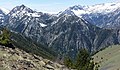
Bonneville Mountain is located eight miles south of Joseph, Oregon, in the Wallowa Mountains. It is set within the Eagle Cap Wilderness on land managed by Wallowa–Whitman National Forest.[2] The peak is situated south of Wallowa Lake and precipitation runoff from the mountain drains west into West Fork Wallowa River and east into the East Fork. Topographic relief is significant as the summit rises over 3,700 feet (1,100 meters) above the lake in approximately three miles.
Etymology

This landform's toponym was officially adopted in 1925 by the United States Board on Geographic Names to honor Benjamin Bonneville (1796–1878), an officer in the United States Army and explorer of the American West noted for his expeditions to the Oregon Country.[3] Captain Bonneville and his party are credited with the first documented entry into the Wallowa Valley by a non-native in 1834.[5] This mountain was originally known as Middle Mountain.[6]
Climate
Based on the Köppen climate classification, Chief Joseph Mountain is located in a subarctic climate zone characterized by long, usually very cold winters, and mild summers.[7] Winter temperatures can drop below −10 °F with wind chill factors below −20 °F. Most precipitation in the area is caused by orographic lift. Thunderstorms are common in the summer.
See also
Gallery
-
 Bonneville Mountain seen from Rocking OK Ranch
 -
 Bonneville Mountain seen from Mt. Howard.
 -

-
 North aspect from the north end of Wallowa Lake.


References
- ^ a b "Bonneville Mountain - 8,140' OR". listsofjohn.com. Retrieved 2022-10-07.
- ^ a b "Bonneville Mountain, Oregon". Peakbagger.com. Retrieved 2022-10-07.
- ^ a b "Bonneville Mountain". Geographic Names Information System. United States Geological Survey, United States Department of the Interior. Retrieved 2022-10-07.
- ^ Fred Barstad (2021), Hiking Oregon's Eagle Cap Wilderness, Falcon Guides, ISBN 9781493043774, p. 361
- ^ Lewis Ankeny McArthur, Lewis L. McArthur, Oregon Geographic Names, Volume 2, (2003), Oregon Historical Society Press, ISBN 9780875952789, p. 496
- ^ Frederic George Young, "Oregon Historical Quarterly" Volume 27, (1926), p. 351
- ^ Peel, M. C.; Finlayson, B. L.; McMahon, T. A. (2007). "Updated world map of the Köppen−Geiger climate classification". Hydrol. Earth Syst. Sci. 11: 1633–1644. ISSN 1027-5606.
External links
Wikimedia Commons has media related to Wallowa Mountains.
- Weather forecast: Bonneville Mountain
Portals:
 Geography
 Geology
 Mountains
 Oregon


Places adjacent to Bonneville Mountain | ||||||||||||||||
|---|---|---|---|---|---|---|---|---|---|---|---|---|---|---|---|---|
| ||||||||||||||||


