Caer Lêb
Archaeological site in Anglesey, Wales
53°10′54″N 4°17′12″W / 53.1818°N 4.2868°W / 53.1818; -4.2868
Caer Lêb is a Roman and mediaeval site on the Welsh island of Anglesey, west of Brynsiencyn. Its name means "Leaven Castle". It is a low-lying site near the Afon Braint with a double row of pentangular banks (some parts now levelled) and marshy ditches. The original entrance was on the east, other gaps are modern and caused by animals.[1] Based on the excavation of a similar site elsewhere on Anglesey, it may date from the 2nd century BCE.[2]
Excavations in 1865 found structures within the enclosure, rectangular buildings on the east and a circular one on the south. Nothing of these can now be seen on the ground. Pottery from the 2nd century to the 4th century was found, and on the north side a layer of periwinkle shells and a mediaeval coin, under a layer of peat.[2]
There is a parking area, sufficient for 4-5 cars, by the roadside. A footpath goes southwest on a low ridge, some 2 metres above the Afon Braint, from Caer Lêb over stiles, past the site of the former stone circle of Tre'r Dryw Bach, some 800 metres to Castell Bryn Gwyn and on to the Bryn Gwyn stones and the A4080.
500 metres north-west along the road, by Pont Sarn Las (Green Causeway Bridge), the foundations of three round houses may be visible after a dry summer. A large settlement was recorded in the 19th century, and destroyed in the 1870s by agricultural improvement.[1]
Gallery
-
 Plan of Caer Lêb, an earthwork on Anglesey, with details of excavations in 1866
 -
 Caer Lêb from the south-western rampart
 -
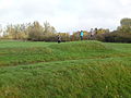
 Caer Lêb from outer rampart


References
- ^ a b Frances Lynch. A guide to ancient and historic Wales. Gwynedd. ISBN 0-11-701574-1. HMSO 1995. pp 89-90
- ^ a b Cadw information board at the site
External links
Wikimedia Commons has media related to Caer Lêb.
- v
- t
- e
Anglesey
- Amlwch
- Beaumaris
- Benllech
- Holyhead
- Llangefni
- Menai Bridge

- Aberffraw
- Bachau
- Bodedern
- Bodewryd
- Bodffordd
- Bodorgan
- Bryngwran
- Brynrefail
- Brynsiencyn
- Bull Bay
- Burwen
- Cemaes
- Cemaes Bay
- Cemlyn
- Church Bay
- Dwyran
- Four Mile Bridge
- Gaerwen
- Glan-yr-afon (Bodffordd)
- Gors
- Gwalchmai
- Pont-Hwfa
- Llaingoch
- Llanbadrig
- Llanddaniel Fab
- Llanddeusant
- Llanddona
- Llandegfan
- Llanfaelog
- Llanfaes
- Llanfairpwllgwyngyll
- Llanfair-yng-Nghornwy
- Llanfechell
- Llanfwrog
- Llangoed
- Llangristiolus
- Llangwyllog
- Llanidan
- Llannerch-y-medd
- Llanrhyddlad
- Llansadwrn
- Llantrisant
- Maenaddwyn
- Malltraeth
- Marian-glas
- Moelfre
- Newborough
- Penmon
- Penmynydd
- Pentraeth
- Pentre Berw
- Plas Llanfair
- Porth Dafarch
- Prys-Iorwerth
- Rhoscolyn
- Rhosgoch
- Rhosybol
- Rhosmeirch
- Rhosneigr
- Rhosydd
- Rhydwyn
- Tandinas
- Trearddur
- Tregele
- Tŷ Croes
- Valley
- Communities
- Parliamentary constituencies
- Places
- Schools
- Listed Buildings
- Museums
- Scheduled Monuments
- Registered parks and gardens
- SSSIs
- Country houses
- Lord Lieutenants
- High Sheriffs
- Public art
 Geography
 Wales
Wales


53°10′55″N 4°17′12″W / 53.181885°N 4.286781°W / 53.181885; -4.286781


