Caimito, Sucre
Municipality and town in Sucre Department, Colombia

Flag
Remanzo de Paz (In Spanish)

Location of the municipality and town of Caimito, Sucre in the Sucre Department of Colombia.
 Colombia
 (Census 2023[2])
San Juan de Caimito, also known as Caimito. Is a town and municipality located in the Sucre Department, northern Colombia.
Gallery
-
 Panoramic View of La Cienaga de Caimito, at north of the Municipality Seat. Sucre, Colombia.
 -
 I.E San Juan Bautista. Santa Teresita´s Campus. Caimito, Sucre, Colombia
 -
 Long Exposure Photo Showing the Moon from Caimito, Sucre.
 -
 San Juan Bautista Church's South Park at rainy day.
 -
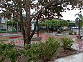
 San Juan Bautista Church's North Park at sunny day


References
- (in Spanish) Gobernacion de Sucre - Caimito
- (in Spanish) Caimito official website
- v
- t
- e
Municipalities in Sucre Department
- Buenavista
- Caimito
- Chalán
- Colosó
- Corozal
- Coveñas
- El Roble
- Galeras
- Guaranda
- La Unión
- Los Palmitos
- Majagual
- Morroa
- Ovejas
- Palmito
- Sampués
- San Benito Abad
- San Juan Betulia
- San Marcos
- San Onofre
- San Pedro
- Sincé
- Sincelejo
- Sucre
- Tolú
- Toluviejo

 | This Sucre Department location article is a stub. You can help Wikipedia by expanding it. |
- v
- t
- e
8°50′N 75°10′W / 8.833°N 75.167°W / 8.833; -75.167


