Cellettes, Charente
Commune in Nouvelle-Aquitaine, France
Location of Cellettes

(2020–2026) Norbert Aguesseau[1]
1
(2021)[2]
16069 /16230
(avg. 105 m or 344 ft)
Cellettes (French pronunciation: [selɛt]) is a commune in the Charente department, Southwestern France.
Population
| Year | Pop. | ±% p.a. |
|---|---|---|
| 1968 | 259 | — |
| 1975 | 222 | −2.18% |
| 1982 | 294 | +4.09% |
| 1990 | 346 | +2.06% |
| 1999 | 415 | +2.04% |
| 2009 | 440 | +0.59% |
| 2014 | 429 | −0.51% |
| 2020 | 385 | −1.79% |
| Source: INSEE[3] | ||
Gallery
-
 Forêt de Boixe in winter
 -
 Dolmen also wrongly said as a "sacrifice table", is located in the Forêt de Boixe
 -
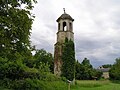 Chapel of the Château d'Échoisy


See also
References
- ^ "Répertoire national des élus: les maires". data.gouv.fr, Plateforme ouverte des données publiques françaises (in French). 9 August 2021.
- ^ "Populations légales 2021". The National Institute of Statistics and Economic Studies. 28 December 2023.
- ^ Population en historique depuis 1968, INSEE
Wikimedia Commons has media related to Cellettes (Charente).
- v
- t
- e
Communes of the Charente department 

- Abzac
- Les Adjots
- Agris
- Aigre
- Alloue
- Ambérac
- Ambernac
- Anais
- Angeac-Champagne
- Angeac-Charente
- Angeduc
- Angoulêmepref
- Ansac-sur-Vienne
- Ars
- Asnières-sur-Nouère
- Aubeterre-sur-Dronne
- Aunac-sur-Charente
- Aussac-Vadalle
- Baignes-Sainte-Radegonde
- Balzac
- Barbezières
- Barbezieux-Saint-Hilaire
- Bardenac
- Barret
- Barro
- Bassac
- Bazac
- Beaulieu-sur-Sonnette
- Bécheresse
- Bellevigne
- Bellon
- Benest
- Bernac
- Berneuil
- Bessac
- Bessé
- Bioussac
- Birac
- Blanzaguet-Saint-Cybard
- Boisbreteau
- Boisné-la-Tude
- Bonnes
- Bonneuil
- Bors-de-Baignes
- Bors-de-Montmoreau
- Le Bouchage
- Bouëx
- Bourg-Charente
- Bouteville
- Boutiers-Saint-Trojan
- Brettes
- Bréville
- Brie
- Brie-sous-Barbezieux
- Brie-sous-Chalais
- Brigueuil
- Brillac
- Brossac
- Bunzac
- Cellefrouin
- Cellettes
- Chabanais
- Chabrac
- Chadurie
- Chalais
- Challignac
- Champagne-Mouton
- Champagne-Vigny
- Champmillon
- Champniers
- Chantillac
- La Chapelle
- Charmé
- Charras
- Chasseneuil-sur-Bonnieure
- Chassenon
- Chassiecq
- Chassors
- Châteaubernard
- Châteauneuf-sur-Charente
- Châtignac
- Chazelles
- Chenon
- Cherves-Châtelars
- La Chèvrerie
- Chillac
- Chirac
- Claix
- Cognacsubpr
- Combiers
- Condac
- Condéon
- Confolenssubpr
- Coteaux du Blanzacais
- Coulgens
- Coulonges
- Courbillac
- Courcôme
- Courgeac
- Courlac
- La Couronne
- Couture
- Criteuil-la-Magdeleine
- Curac
- Deviat
- Dignac
- Dirac
- Douzat
- Ébréon
- Échallat
- Écuras
- Édon
- Empuré
- Épenède
- Les Essards
- Esse
- Étagnac
- Étriac
- Exideuil-sur-Vienne
- Eymouthiers
- La Faye
- Feuillade
- Fléac
- Fleurac
- Fontenille
- La Forêt-de-Tessé
- Fouquebrune
- Fouqueure
- Foussignac
- Garat
- Gardes-le-Pontaroux
- Genac-Bignac
- Gensac-la-Pallue
- Genté
- Gimeux
- Gond-Pontouvre
- Les Gours
- Le Grand-Madieu
- Grassac
- Graves-Saint-Amant
- Guimps
- Guizengeard
- Gurat
- Hiersac
- Hiesse
- Houlette
- L'Isle-d'Espagnac
- Jarnac
- Jauldes
- Javrezac
- Juignac
- Juillac-le-Coq
- Juillé
- Julienne
- Lachaise
- Ladiville
- Lagarde-sur-le-Né
- Laprade
- Lésignac-Durand
- Lessac
- Lesterps
- Lichères
- Ligné
- Lignières-Ambleville
- Linars
- Le Lindois
- Londigny
- Longré
- Lonnes
- Louzac-Saint-André
- Lupsault
- Lussac
- Luxé
- La Magdeleine
- Magnac-Lavalette-Villars
- Magnac-sur-Touvre
- Maine-de-Boixe
- Mainxe-Gondeville
- Mainzac
- Manot
- Mansle-les-Fontaines
- Marcillac-Lanville
- Mareuil
- Marillac-le-Franc
- Marsac
- Marthon
- Massignac
- Mazerolles
- Médillac
- Mérignac
- Merpins
- Mesnac
- Les Métairies
- Mons
- Montboyer
- Montbron
- Montembœuf
- Montignac-Charente
- Montignac-le-Coq
- Montjean
- Montmérac
- Montmoreau
- Montrollet
- Mornac
- Mosnac-Saint-Simeux
- Moulidars
- Moulins-sur-Tardoire
- Mouthiers-sur-Boëme
- Mouton
- Moutonneau
- Mouzon
- Nabinaud
- Nanclars
- Nanteuil-en-Vallée
- Nercillac
- Nersac
- Nieuil
- Nonac
- Oradour
- Oradour-Fanais
- Orgedeuil
- Oriolles
- Orival
- Paizay-Naudouin-Embourie
- Palluaud
- Parzac
- Passirac
- Pérignac
- Pillac
- Les Pins
- Plassac-Rouffiac
- Pleuville
- Poullignac
- Poursac
- Pranzac
- Pressignac
- Puymoyen
- Puyréaux
- Raix
- Ranville-Breuillaud
- Reignac
- Réparsac
- Rioux-Martin
- Rivières
- La Rochefoucauld-en-Angoumois
- La Rochette
- Ronsenac
- Rouffiac
- Rougnac
- Rouillac
- Roullet-Saint-Estèphe
- Roussines
- Rouzède
- Ruelle-sur-Touvre
- Ruffec
- Saint-Adjutory
- Saint-Amant-de-Boixe
- Saint-Amant-de-Nouère
- Saint-Aulais-la-Chapelle
- Saint-Avit
- Saint-Bonnet
- Saint-Brice
- Saint-Christophe
- Saint-Ciers-sur-Bonnieure
- Saint-Claud
- Saint-Coutant
- Saint-Cybardeaux
- Sainte-Sévère
- Sainte-Souline
- Saint-Félix
- Saint-Fort-sur-le-Né
- Saint-Fraigne
- Saint-Front
- Saint-Genis-d'Hiersac
- Saint-Georges
- Saint-Germain-de-Montbron
- Saint-Gourson
- Saint-Groux
- Saint-Laurent-de-Céris
- Saint-Laurent-de-Cognac
- Saint-Laurent-des-Combes
- Saint-Martial
- Saint-Martin-du-Clocher
- Saint-Mary
- Saint-Maurice-des-Lions
- Saint-Médard
- Saint-Même-les-Carrières
- Saint-Michel
- Saint-Palais-du-Né
- Saint-Preuil
- Saint-Quentin-de-Chalais
- Saint-Quentin-sur-Charente
- Saint-Romain
- Saint-Saturnin
- Saint-Séverin
- Saint-Simon
- Saint-Sornin
- Saint-Sulpice-de-Ruffec
- Saint-Vallier
- Saint-Yrieix-sur-Charente
- Salles-d'Angles
- Salles-de-Barbezieux
- Salles-de-Villefagnan
- Salles-Lavalette
- Saulgond
- Sauvagnac
- Sauvignac
- Segonzac
- Sers
- Sigogne
- Sireuil
- Souffrignac
- Souvigné
- Soyaux
- Suaux
- La Tâche
- Taizé-Aizie
- Taponnat-Fleurignac
- Le Tâtre
- Terres-de-Haute-Charente
- Theil-Rabier
- Torsac
- Tourriers
- Touvérac
- Touvre
- Triac-Lautrait
- Trois-Palis
- Turgon
- Tusson
- Val-d'Auge
- Val-de-Bonnieure
- Val-de-Cognac
- Val-des-Vignes
- Valence
- Vars
- Vaux-Lavalette
- Vaux-Rouillac
- Ventouse
- Verdille
- Verneuil
- Verrières
- Verteuil-sur-Charente
- Vervant
- Vibrac
- Le Vieux-Cérier
- Vieux-Ruffec
- Vignolles
- Villebois-Lavalette
- Villefagnan
- Villejoubert
- Villiers-le-Roux
- Villognon
- Vindelle
- Vitrac-Saint-Vincent
- Vœuil-et-Giget
- Vouharte
- Voulgézac
- Vouthon
- Vouzan
- Xambes
- Yviers
- Yvrac-et-Malleyrand
- pref: prefecture
- subpr: subprefecture
| Authority control databases: National |
|
|---|
 | This Charente geographical article is a stub. You can help Wikipedia by expanding it. |
- v
- t
- e


