Chapet
Commune in Île-de-France, France
Location of Chapet

(2020–2026) Benoît de Laurens[1]
1
(2021)[2]
78140 /78130
(avg. 59 m or 194 ft)
Chapet (French pronunciation: [ʃapɛ] ⓘ) is a commune in the Yvelines department in the Île-de-France region in north-central France, about 16 km east of Mantes-la-Jolie. It is on the Normandy motorway (A13).
The commune's neighbours are Verneuil-sur-Seine to the northeast, to the east is Vernouillet, with Morainvilliers to the southeast, Ecquevilly to the southwest, and to the northwest is Les Mureaux.
It is a largely rural and agricultural community; the land is divided mainly between arable crops (cereals, oilseed rape) with some woods and forest.
The parish church of Saint-Denis dates from the 12th century. The bell-tower was added in 1859.
See also
References
- ^ "Répertoire national des élus: les maires" (in French). data.gouv.fr, Plateforme ouverte des données publiques françaises. 4 May 2022.
- ^ "Populations légales 2021". The National Institute of Statistics and Economic Studies. 28 December 2023.
-
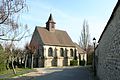 Saint-Denis
 -
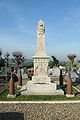 War memorial
 -
 Grande Rue
 -
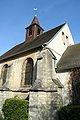 Belfry
 -
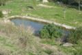 Pond
Pond


Wikimedia Commons has media related to Chapet.
- v
- t
- e
Communes of the Yvelines department 

- Ablis
- Achères
- Adainville
- Aigremont
- Allainville
- Les Alluets-le-Roi
- Andelu
- Andrésy
- Arnouville-lès-Mantes
- Aubergenville
- Auffargis
- Auffreville-Brasseuil
- Aulnay-sur-Mauldre
- Auteuil
- Autouillet
- Bailly
- Bazainville
- Bazemont
- Bazoches-sur-Guyonne
- Béhoust
- Bennecourt
- Beynes
- Blaru
- Boinville-en-Mantois
- Boinville-le-Gaillard
- Boinvilliers
- Bois-d'Arcy
- Boissets
- La Boissière-École
- Boissy-Mauvoisin
- Boissy-sans-Avoir
- Bonnelles
- Bonnières-sur-Seine
- Bouafle
- Bougival
- Bourdonné
- Breuil-Bois-Robert
- Bréval
- Les Bréviaires
- Brueil-en-Vexin
- Buc
- Buchelay
- Bullion
- Carrières-sous-Poissy
- Carrières-sur-Seine
- La Celle-les-Bordes
- La Celle-Saint-Cloud
- Cernay-la-Ville
- Chambourcy
- Chanteloup-les-Vignes
- Chapet
- Châteaufort
- Chatou
- Chaufour-lès-Bonnières
- Chavenay
- Le Chesnay-Rocquencourt
- Chevreuse
- Choisel
- Civry-la-Forêt
- Clairefontaine-en-Yvelines
- Les Clayes-sous-Bois
- Coignières
- Condé-sur-Vesgre
- Conflans-Sainte-Honorine
- Courgent
- Cravent
- Crespières
- Croissy-sur-Seine
- Dammartin-en-Serve
- Dampierre-en-Yvelines
- Dannemarie
- Davron
- Drocourt
- Ecquevilly
- Élancourt
- Émancé
- Épône
- Les Essarts-le-Roi
- L'Étang-la-Ville
- Évecquemont
- La Falaise
- Favrieux
- Feucherolles
- Flacourt
- Flexanville
- Flins-Neuve-Église
- Flins-sur-Seine
- Follainville-Dennemont
- Fontenay-le-Fleury
- Fontenay-Mauvoisin
- Fontenay-Saint-Père
- Freneuse
- Gaillon-sur-Montcient
- Galluis
- Gambais
- Gambaiseuil
- Garancières
- Gargenville
- Gazeran
- Gommecourt
- Goupillières
- Goussonville
- Grandchamp
- Gressey
- Grosrouvre
- Guernes
- Guerville
- Guitrancourt
- Guyancourt
- Hardricourt
- Hargeville
- La Hauteville
- Herbeville
- Hermeray
- Houdan
- Houilles
- Issou
- Jambville
- Jouars-Pontchartrain
- Jouy-en-Josas
- Jouy-Mauvoisin
- Jumeauville
- Juziers
- Lainville-en-Vexin
- Lévis-Saint-Nom
- Limay
- Limetz-Villez
- Les Loges-en-Josas
- Lommoye
- Longnes
- Longvilliers
- Louveciennes
- Magnanville
- Magny-les-Hameaux
- Maisons-Laffitte
- Mantes-la-Joliesubpr
- Mantes-la-Ville
- Marcq
- Mareil-le-Guyon
- Mareil-Marly
- Mareil-sur-Mauldre
- Marly-le-Roi
- Maule
- Maulette
- Maurecourt
- Maurepas
- Médan
- Ménerville
- Méré
- Méricourt
- Le Mesnil-le-Roi
- Le Mesnil-Saint-Denis
- Les Mesnuls
- Meulan-en-Yvelines
- Mézières-sur-Seine
- Mézy-sur-Seine
- Millemont
- Milon-la-Chapelle
- Mittainville
- Moisson
- Mondreville
- Montainville
- Montalet-le-Bois
- Montchauvet
- Montesson
- Montfort-l'Amaury
- Montigny-le-Bretonneux
- Morainvilliers
- Mousseaux-sur-Seine
- Mulcent
- Les Mureaux
- Neauphle-le-Château
- Neauphle-le-Vieux
- Neauphlette
- Nézel
- Noisy-le-Roi
- Notre-Dame-de-la-Mer
- Oinville-sur-Montcient
- Orcemont
- Orgerus
- Orgeval
- Orphin
- Orsonville
- Orvilliers
- Osmoy
- Paray-Douaville
- Le Pecq
- Perdreauville
- Le Perray-en-Yvelines
- Plaisir
- Poigny-la-Forêt
- Poissy
- Ponthévrard
- Porcheville
- Le Port-Marly
- Prunay-en-Yvelines
- Prunay-le-Temple
- La Queue-les-Yvelines
- Raizeux
- Rambouilletsubpr
- Rennemoulin
- Richebourg
- Rochefort-en-Yvelines
- Rolleboise
- Rosay
- Rosny-sur-Seine
- Sailly
- Saint-Arnoult-en-Yvelines
- Saint-Cyr-l'École
- Sainte-Mesme
- Saint-Forget
- Saint-Germain-de-la-Grange
- Saint-Germain-en-Layesubpr
- Saint-Hilarion
- Saint-Illiers-la-Ville
- Saint-Illiers-le-Bois
- Saint-Lambert
- Saint-Léger-en-Yvelines
- Saint-Martin-de-Bréthencourt
- Saint-Martin-des-Champs
- Saint-Martin-la-Garenne
- Saint-Nom-la-Bretèche
- Saint-Rémy-lès-Chevreuse
- Saint-Rémy-l'Honoré
- Sartrouville
- Saulx-Marchais
- Senlisse
- Septeuil
- Soindres
- Sonchamp
- Tacoignières
- Le Tartre-Gaudran
- Le Tertre-Saint-Denis
- Tessancourt-sur-Aubette
- Thiverval-Grignon
- Thoiry
- Tilly
- Toussus-le-Noble
- Trappes
- Le Tremblay-sur-Mauldre
- Triel-sur-Seine
- Vaux-sur-Seine
- Vélizy-Villacoublay
- Verneuil-sur-Seine
- Vernouillet
- La Verrière
- Versaillespref
- Vert
- Le Vésinet
- Vicq
- Vieille-Église-en-Yvelines
- La Villeneuve-en-Chevrie
- Villennes-sur-Seine
- Villepreux
- Villette
- Villiers-le-Mahieu
- Villiers-Saint-Frédéric
- Viroflay
- Voisins-le-Bretonneux
- pref: prefecture
- subpr: subprefecture
| Authority control databases: National |
|
|---|
 | This Yvelines geographical article is a stub. You can help Wikipedia by expanding it. |
- v
- t
- e


