Crêt de la Neige


Le Crêt de la Neige
France
Le Crêt de la Neige is the highest peak in the Jura Mountains and the department of Ain in France. Its elevation is 1720 m above sea level (reported as 1718 m before 2003). Its prominence is 1260 m. It is located in the commune of Thoiry.
-
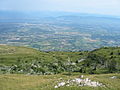 Looking towards Geneva from the summit
 -
 Summit of the Crêt de la Neige, with Le Reculet in the background


References
- ^ Retrieved from the IGN topographic maps [1]
- ^ Retrieved from the Swisstopo topographic maps [2]. The lowest col between the Jura and the Alps is located at the Canal d’Entreroches (in Switzerland), at approximately 460 metres above sea level.
- ^ Retrieved from the Swisstopo topographic maps. The nearest point of higher elevation is northwest of the Montagne de Sous Dine.
Authority control databases | |
|---|---|
| International |
|
| National |
|
- v
- t
- e


