Farrell Flat
Town in South Australia
33°50′0″S 138°48′0″E / 33.83333°S 138.80000°E / -33.83333; 138.80000- 151 km (94 mi) N of Adelaide
- 20 km (12 mi) E of Clare
- 22 km (14 mi) SW of Burra
| Localities around Farrell Flat: | ||
| Hill River | Gum Creek | Hanson |
| Clare | Farrell Flat | Porter Lagoon |
| Mintaro | Manoora | Black Springs |
Farrell Flat (formerly Hanson)[2] is a town in South Australia. The town is located 20 kilometres (12 mi) east of Clare and 22 kilometres (14 mi) southwest of Burra on the former Peterborough railway line, in the Regional Council of Goyder.

Once the heart of a thriving farming community, Farrell Flat today is largely a satellite town to the larger towns nearby. It has retained its own identity, with a functioning hotel, cafe and meeting house, engineering business and grain silos.
The town was surveyed as Hanson in 1870 and did not officially become Farrell Flat until 19 September 1940.[3] The name Farrell's Flat had been in use for some time, this being the name of the railway station.[4] The nearby town of Davies was officially renamed to Hanson on 19 September 1940.[4]
Farrell Flat was named for Colonial Chaplain and Dean of Adelaide, James Farrell (26 November 1803 – 26 April 1869)

See also
Gallery
-
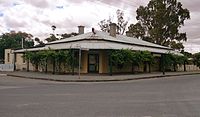 Farrell Flat Hotel in 2013
 -
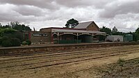 Farrell Flat Railway Station in 2013
 -
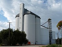 Silos
Silos -
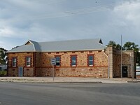 Farrell Flat Institute 1912
 -
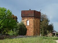 Railway Water Tank


References
- ^ Australian Bureau of Statistics (28 June 2022). "Farrell Flat (suburb and locality)". Australian Census 2021 QuickStats. Retrieved 28 June 2022.

- ^ Farrell Flat Archived 1 April 2018 at the Wayback Machine. South Australian History. Retrieved 1 April 2018.
- ^ "NEW TOWN NAMES APPROVED". The Advertiser. South Australia. 26 July 1940. p. 10. Retrieved 5 September 2016 – via National Library of Australia.
- ^ a b Towns and other places in the District, www.burrahistory.info Retrieved on 8 November 2014
- v
- t
- e
Towns and localities of the Regional Council of Goyder
- Apoinga
- Australia Plains
- Baldina
- Booborowie
- Bower
- Brady Creek
- Bright
- Brownlow
- Buchanan
- Bundey
- Burra
- Burra Eastern Districts
- Canowie
- Canowie Belt
- Collinsville
- Dutton (part)
- Emu Downs
- Eudunda
- Farrell Flat
- Franklyn
- Frankton
- Geranium Plains
- Gum Creek
- Hallelujah Hills
- Hallett
- Hampden
- Hansborough
- Hanson
- Julia
- Koonoona
- Leighton
- Mongolata
- Mount Bryan
- Mount Bryan East
- Neales Flat
- Ngapala
- North Booborowie
- Peep Hill
- Pine Creek
- Point Pass
- Porter Lagoon
- Robertstown
- Rocky Plain
- Steinfeld
- Sutherlands
- Terowie
- Ulooloo
- Whyte Yarcowie
- Willalo
- Wonna
- Worlds End
 | This South Australia geography article is a stub. You can help Wikipedia by expanding it. |
- v
- t
- e


