Federico Lacroze railway station
Railway station in Buenos Aires, Argentina


Federico Lacroze station
Location within Buenos Aires
Show map of Buenos Aires
Federico Lacroze station
Federico Lacroze station (Argentina)
Show map of Argentina
Federico Lacroze railway station (Estación Federico Lacroze in Spanish) is a passenger railway station in Buenos Aires, Argentina. The station is located in the city's outlying barrio (neighbourhood) of Chacarita in a predominantly residential area. It is just a short distance north of the Cementerio de la Chacarita,[1] the city's largest cemetery. The station is named after Federico Lacroze, a prominent 19th century Argentine railway and transport pioneer who obtained the concession for building the Buenos Aires Central Railway in 1884. When the Argentine railway network was nationalised in 1948 the station became the Buenos Aires terminus for the lines that became part of the General Urquiza Railway (FCGU).
History

The first station to open was "Chacarita" terminus, a precarious building that served as terminal for the Buenos Aires Central Railway, originally a horse-drawn railway established by entrepreneur Federico Lacroze that built and operated a line to cities of Zárate in Buenos Aires and 4 de Febrero in Santa Fe.[2] The station would be later demolished.

The current underground station had been designed by the Lacroze Brothers with the intention of being a connection with the Buenos Aires Central Railway. The tunnels and parts of the original station are used for Line B to this day.[3]
The current terminal was designed by Argentine architect Santiago Mayaud-Maisonneuve and his son Carlos in 1951, following the Rationalist style of architecture. It was inaugurated in 1957 and its construction financed by the state, as the railways were state-owned at the time. The building received protected status in 2009.[4]
Services
The station functions primarily as a commuter rail station but also handles some long-distance services. The local transit company Metrovías, which also manages the Buenos Aires Underground system, operates regular electric commuter train services every 10–20 minutes into the nearby Buenos Aires suburbs along its Urquiza Line. Stations on this line include Villa Devoto, Martín Coronado (which also serves Ciudad Jardín), Hurlingham and San Miguel amongst others.
In the past, the station also served as the terminal for the long-distance service to Misiones Province, however this service has been suspended as of 2012.[5] Following railway privatisation in Argentina, the private railway company Trenes Especiales Argentinos (TEA) operated long-distance passenger services to the city of Posadas in the very north of Argentina on the border with Paraguay. The service used the standard gauge network of the General Urquiza Railway which runs through the provinces of Buenos Aires, Entre Ríos, Corrientes and Misiones. This train stopped at many places on the way including Zárate in Buenos Aires Province, Basavilbaso and Villaguay in Entre Ríos Province, Monte Caseros and Santo Tomé in Corrientes Province. In 2012 the service was briefly taken over by Trenes de Buenos Aires, however their concession was revoked by the National Government on the same year and remains without an operator to this day.
There have been numerous calls for the return of the service given the large-scale reactivation of many of the country's railways since 2014, however as of 2015, the service remains suspended.[6][7]
Federico Lacroze station is accessible from the B line of the Buenos Aires Underground system from the station there and by numerous local public bus services.[8] In 2014, the station underwent restoration works in its main hall and platforms.[9]
Historic operators
| Operator | Period |
|---|---|
 Buenos Aires Central Railway Buenos Aires Central Railway | 1888–1948 |
| Ferrocarriles Argentinos | 1948–1991 |
| FEMESA [n 1] | 1991–1994 |
| Metrovías | 1994–present |
- Notes
- ^ Temporary operator prior to the privatization of commuter rail services.
Gallery
-
 Facade
 -
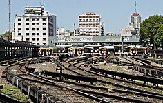 Aerial view
 -
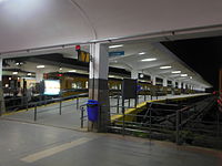 Platforms
 -
 View from Corrientes Avenue
 -
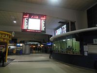 Hall and board
 -
 Train platforms


See also
 Argentina portal
References
- ^ Estación Federico Lacroze Archived 2015-04-03 at the Wayback Machine - Tren Urquiza
- ^ Ferrocarril Urquiza - Historia Archived 2019-03-15 at the Wayback Machine, Metrovías website
- ^ Construcción de túneles de subte - EnElSubte, 24 August 2008
- ^ Más piezas para el catálogo - Pagina/12, 30 May 2009
- ^ F. Lacroze - Apóstoles - Posadas - Satélite Ferroviario
- ^ ¿No saben cómo hacer a un pueblo felíz?. El regreso del tren de pasajeros "El Gran Capitán" en 2003 - Crónica Ferroviaria, 06 April, 2015
- ^ Misiones: El Defensor del Pueblo provincial solicitó que se restablezca el servicio ferroviario entre Posadas - Buenos Aires - Cronica Ferroviaria, 03 February 2015
- ^ Estacion Federico Lacroze - XColectivo
- ^ Mejoras en la estación Federico Lacroze de la Línea Urquiza - Estacion AZ, 21 October 2014
External links
Wikimedia Commons has media related to F. Lacroze station.
- Metrovías English website
- Trenes Especiales Argentinos web site
- Google Maps Satellite Photo
- Estudio | Artes | Oficios (Spanish)
- v
- t
- e
- Retiro
- Constitución
- Once de Septiembre
- Federico Lacroze
- Buenos Aires (Belgrano Sur)
 Argentina portal
Railway stations in Argentina | |||||
|---|---|---|---|---|---|
| Buenos Aires |
| ||||
| Córdoba | |||||
| Mendoza | |||||
| Neuquén | |||||
| Río Negro | |||||
| Santa Fe |
| ||||
| Tucumán | |||||
| |||||

34°35′12″S 58°27′20″W / 34.58667°S 58.45556°W / -34.58667; -58.45556


