Gémonval
Commune in Bourgogne-Franche-Comté, France
Location of Gémonval

(2020–2026) Fabrice Vrillacq[1]
1
(2021)[2]
25264 /25250
Gémonval (French pronunciation: [ʒemɔ̃val]) is a commune in the Doubs department in the Bourgogne-Franche-Comté region in eastern France.
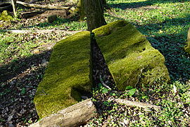
Coal mines were operated in the village between 1826 and 1944.
-
 Mine shaft of Elisabeth.
 -
 Mine shaft de la Houillère.
 -
 Mine shaft des Essarts.
 -
 Plinth of steam machine in mine shaft des Essarts.


-
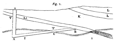 A sectional view of the mine-schaft #3.
ht : "houille tendre" (coal),
hg (gray) : "houille gypseuse" (coal).

Population
| Year | Pop. | ±% |
|---|---|---|
| 1962 | 76 | — |
| 1968 | 92 | +21.1% |
| 1975 | 75 | −18.5% |
| 1982 | 86 | +14.7% |
| 1990 | 100 | +16.3% |
| 1999 | 75 | −25.0% |
| 2008 | 88 | +17.3% |
| 2012 | 77 | −12.5% |
See also
References
- ^ "Répertoire national des élus: les maires". data.gouv.fr, Plateforme ouverte des données publiques françaises (in French). 2 December 2020.
- ^ "Populations légales 2021". The National Institute of Statistics and Economic Studies. 28 December 2023.
Wikimedia Commons has media related to Gémonval.
- v
- t
- e
Communes of the Doubs department 

- Abbans-Dessous
- Abbans-Dessus
- Abbenans
- Abbévillers
- Accolans
- Adam-lès-Passavant
- Adam-lès-Vercel
- Aibre
- Aïssey
- Allenjoie
- Les Alliés
- Allondans
- Amagney
- Amancey
- Amathay-Vésigneux
- Amondans
- Anteuil
- Appenans
- Arbouans
- Arc-et-Senans
- Arcey
- Arçon
- Arc-sous-Cicon
- Arc-sous-Montenot
- Aubonne
- Audeux
- Audincourt
- Autechaux
- Autechaux-Roide
- Les Auxons
- Avanne-Aveney
- Avilley
- Avoudrey
- Badevel
- Bannans
- Le Barboux
- Bart
- Bartherans
- Battenans-les-Mines
- Battenans-Varin
- Baume-les-Dames
- Bavans
- Belfays
- Le Bélieu
- Belleherbe
- Belmont
- Belvoir
- Berche
- Berthelange
- Besançonpref
- Bethoncourt
- Beure
- Beutal
- Bief
- Le Bizot
- Blamont
- Blarians
- Blussangeaux
- Blussans
- Bolandoz
- Bondeval
- Bonnal
- Bonnay
- Bonnétage
- Bonnevaux
- La Bosse
- Bouclans
- Boujailles
- Bourguignon
- Bournois
- Boussières
- Bouverans
- Braillans
- Branne
- Breconchaux
- Bremondans
- Brères
- Les Bréseux
- La Bretenière
- Bretigney
- Bretigney-Notre-Dame
- Bretonvillers
- Brey-et-Maison-du-Bois
- Brognard
- Buffard
- Bugny
- Bulle
- Burgille
- Burnevillers
- Busy
- By
- Byans-sur-Doubs
- Cademène
- Cendrey
- Cernay-l'Église
- Cessey
- Chaffois
- Chalèze
- Chalezeule
- Chamesey
- Chamesol
- Champagney
- Champlive
- Champoux
- Champvans-les-Moulins
- Chantrans
- Chapelle-des-Bois
- Chapelle-d'Huin
- Charmauvillers
- Charmoille
- Charnay
- Charquemont
- Chassagne-Saint-Denis
- Châteauvieux-les-Fossés
- Châtelblanc
- Châtillon-Guyotte
- Châtillon-le-Duc
- Chaucenne
- La Chaux
- Chaux-lès-Passavant
- Chaux-Neuve
- Chay
- Chazot
- Chemaudin et Vaux
- La Chenalotte
- Chenecey-Buillon
- Chevigney-lès-Vercel
- Chevigney-sur-l'Ognon
- La Chevillotte
- Chevroz
- Chouzelot
- Cléron
- La Cluse-et-Mijoux
- Colombier-Fontaine
- Les Combes
- Consolation-Maisonnettes
- Corcelle-Mieslot
- Corcelles-Ferrières
- Corcondray
- Côtebrune
- Courcelles
- Courcelles-lès-Montbéliard
- Courchapon
- Cour-Saint-Maurice
- Courtefontaine
- Courtetain-et-Salans
- Courvières
- Crosey-le-Grand
- Crosey-le-Petit
- Le Crouzet
- Crouzet-Migette
- Cubrial
- Cubry
- Cusance
- Cuse-et-Adrisans
- Cussey-sur-Lison
- Cussey-sur-l'Ognon
- Dambelin
- Dambenois
- Dammartin-les-Templiers
- Dampierre-les-Bois
- Dampierre-sur-le-Doubs
- Dampjoux
- Damprichard
- Dannemarie
- Dannemarie-sur-Crète
- Dasle
- Deluz
- Désandans
- Déservillers
- Devecey
- Dommartin
- Dompierre-les-Tilleuls
- Domprel
- Doubs
- Dung
- Durnes
- Échay
- Échenans
- Échevannes
- École-Valentin
- Les Écorces
- Écot
- L'Écouvotte
- Écurcey
- Émagny
- Épenouse
- Épenoy
- Épeugney
- Esnans
- Étalans
- Éternoz
- Étouvans
- Étrabonne
- Étrappe
- Étray
- Étupes
- Évillers
- Exincourt
- Eysson
- Faimbe
- Fallerans
- Ferrières-le-Lac
- Ferrières-les-Bois
- Fertans
- Fesches-le-Châtel
- Fessevillers
- Feule
- Les Fins
- Flagey
- Flagey-Rigney
- Flangebouche
- Fleurey
- Fontain
- Fontaine-lès-Clerval
- Fontenelle-Montby
- Les Fontenelles
- Fontenotte
- Fourbanne
- Fourcatier-et-Maison-Neuve
- Fourg
- Les Fourgs
- Fournet-Blancheroche
- Fournets-Luisans
- Frambouhans
- Franey
- Franois
- Frasne
- Froidevaux
- Fuans
- Gellin
- Gémonval
- Geneuille
- Geney
- Gennes
- Germéfontaine
- Germondans
- Gevresin
- Gilley
- Glamondans
- Glay
- Glère
- Gondenans-les-Moulins
- Gondenans-Montby
- Gonsans
- Gouhelans
- Goumois
- Goux-lès-Dambelin
- Goux-sous-Landet
- Grand-Charmont
- Grand'Combe-Châteleu
- Grand'Combe-des-Bois
- Grandfontaine
- Grandfontaine-sur-Creuse
- La Grange
- Granges-Narboz
- Les Grangettes
- Les Gras
- Le Gratteris
- Grosbois
- Guillon-les-Bains
- Guyans-Durnes
- Guyans-Vennes
- Hauterive-la-Fresse
- Hérimoncourt
- L'Hôpital-du-Grosbois
- L'Hôpital-Saint-Lieffroy
- Les Hôpitaux-Neufs
- Les Hôpitaux-Vieux
- Houtaud
- Huanne-Montmartin
- Hyémondans
- Hyèvre-Magny
- Hyèvre-Paroisse
- Indevillers
- L'Isle-sur-le-Doubs
- Issans
- Jallerange
- Jougne
- Labergement-Sainte-Marie
- Laire
- Laissey
- Lanans
- Landresse
- Lantenne-Vertière
- Lanthenans
- Larnod
- Laval-le-Prieuré
- Lavans-Quingey
- Lavans-Vuillafans
- Lavernay
- Laviron
- Levier
- Liebvillers
- Liesle
- Lizine
- Lods
- Lombard
- Lomont-sur-Crête
- Longechaux
- Longemaison
- Longevelle-lès-Russey
- Longevelle-sur-Doubs
- Longeville
- La Longeville
- Longevilles-Mont-d'Or
- Loray
- Lougres
- Le Luhier
- Luxiol
- Magny-Châtelard
- Maîche
- Maisons-du-Bois-Lièvremont
- Malans
- Malbrans
- Malbuisson
- Malpas
- Mamirolle
- Mancenans
- Mancenans-Lizerne
- Mandeure
- Marchaux-Chaudefontaine
- Marvelise
- Mathay
- Mazerolles-le-Salin
- Médière
- Le Mémont
- Mercey-le-Grand
- Mérey-Vieilley
- Mésandans
- Meslières
- Mesmay
- Métabief
- Miserey-Salines
- Moncey
- Moncley
- Mondon
- Montagney-Servigney
- Montancy
- Montandon
- Montbéliardsubpr
- Montbéliardot
- Montbenoît
- Mont-de-Laval
- Mont-de-Vougney
- Montécheroux
- Montenois
- Montfaucon
- Montferrand-le-Château
- Montflovin
- Montgesoye
- Montivernage
- Montjoie-le-Château
- Montlebon
- Montmahoux
- Montperreux
- Montrond-le-Château
- Les Monts-Ronds
- Montussaint
- Morre
- Morteau
- Mouthe
- Le Moutherot
- Mouthier-Haute-Pierre
- Myon
- Naisey-les-Granges
- Nancray
- Nans
- Nans-sous-Sainte-Anne
- Narbief
- Neuchâtel-Urtière
- Noël-Cerneux
- Noirefontaine
- Noironte
- Nommay
- Novillars
- Ollans
- Onans
- Orchamps-Vennes
- Orgeans-Blanchefontaine
- Ornans
- Orsans
- Orve
- Osse
- Osselle-Routelle
- Ougney-Douvot
- Ouhans
- Ouvans
- Oye-et-Pallet
- Palantine
- Palise
- Paroy
- Passavant
- Passonfontaine
- Pays-de-Clerval
- Pelousey
- Péseux
- Pessans
- Petite-Chaux
- Pierrefontaine-lès-Blamont
- Pierrefontaine-les-Varans
- Pirey
- Placey
- Plaimbois-du-Miroir
- Plaimbois-Vennes
- Les Plains-et-Grands-Essarts
- La Planée
- Pompierre-sur-Doubs
- Pontarliersubpr
- Pont-de-Roide-Vermondans
- Les Pontets
- Pont-les-Moulins
- Pouilley-Français
- Pouilley-les-Vignes
- Pouligney-Lusans
- Les Premiers-Sapins
- Présentevillers
- La Prétière
- Provenchère
- Puessans
- Pugey
- Le Puy
- Quingey
- Rahon
- Rancenay
- Randevillers
- Rang
- Raynans
- Recologne
- Reculfoz
- Rémondans-Vaivre
- Remoray-Boujeons
- Renédale
- Rennes-sur-Loue
- Reugney
- Rigney
- Rignosot
- Rillans
- La Rivière-Drugeon
- Rochejean
- Roche-lès-Clerval
- Roche-lez-Beaupré
- Roches-lès-Blamont
- Rognon
- Romain
- Ronchaux
- Rondefontaine
- Roset-Fluans
- Rosières-sur-Barbèche
- Rosureux
- Rougemont
- Rougemontot
- Rouhe
- Roulans
- Ruffey-le-Château
- Rurey
- Le Russey
- Saint-Antoine
- Sainte-Anne
- Sainte-Colombe
- Sainte-Marie
- Sainte-Suzanne
- Saint-Georges-Armont
- Saint-Gorgon-Main
- Saint-Hilaire
- Saint-Hippolyte
- Saint-Juan
- Saint-Julien-lès-Montbéliard
- Saint-Julien-lès-Russey
- Saint-Maurice-Colombier
- Saint-Point-Lac
- Saint-Vit
- Samson
- Sancey
- Saône
- Saraz
- Sarrageois
- Saules
- Sauvagney
- Scey-Maisières
- Séchin
- Seloncourt
- Semondans
- Septfontaines
- Serre-les-Sapins
- Servin
- Silley-Amancey
- Silley-Bléfond
- Sochaux
- Solemont
- La Sommette
- Soulce-Cernay
- Sourans
- Soye
- Surmont
- Taillecourt
- Tallans
- Tallenay
- Tarcenay-Foucherans
- Les Terres-de-Chaux
- Thiébouhans
- Thise
- Thoraise
- Thulay
- Thurey-le-Mont
- Torpes
- Touillon-et-Loutelet
- La Tour-de-Sçay
- Tournans
- Trépot
- Tressandans
- Trévillers
- Trouvans
- Urtière
- Uzelle
- Vaire
- Le Val
- Valdahon
- Val-de-Roulans
- Val-d'Usiers
- Valentigney
- Valleroy
- Valonne
- Valoreille
- Vandoncourt
- Vaucluse
- Vauclusotte
- Vaudrivillers
- Vaufrey
- Vaux-et-Chantegrue
- Velesmes-Essarts
- Vellerot-lès-Belvoir
- Vellerot-lès-Vercel
- Vellevans
- Venise
- Vennans
- Vennes
- Vercel-Villedieu-le-Camp
- Vergranne
- Verne
- Vernierfontaine
- Vernois-lès-Belvoir
- Le Vernoy
- Verrières-de-Joux
- La Vèze
- Vieilley
- Viéthorey
- Vieux-Charmont
- Villars-lès-Blamont
- Villars-Saint-Georges
- Villars-sous-Dampjoux
- Villars-sous-Écot
- Les Villedieu
- Ville-du-Pont
- Villeneuve-d'Amont
- Villers-Buzon
- Villers-Chief
- Villers-Grélot
- Villers-la-Combe
- Villers-le-Lac
- Villers-Saint-Martin
- Villers-sous-Chalamont
- Voillans
- Voires
- Vorges-les-Pins
- Voujeaucourt
- Vuillafans
- Vuillecin
- Vyt-lès-Belvoir
- pref: prefecture
- subpr: subprefecture
 | This Doubs geographical article is a stub. You can help Wikipedia by expanding it. |
- v
- t
- e


