Glomel
Commune in Brittany, France
Glomel Groñvel | ||
|---|---|---|
Commune | ||
 The church and main road of Glomel | ||
Location of Glomel  | ||
(2023–2026) Bernard Trubuilt[1] | | |
| Area 1 | 79.93 km2 (30.86 sq mi) | |
| Population (2021)[2] | 1,384 | |
| • Density | 17/km2 (45/sq mi) | |
| Time zone | UTC+01:00 (CET) | |
| • Summer (DST) | UTC+02:00 (CEST) | |
| INSEE/Postal code | 22061 /22110 | |
| Elevation | 134–307 m (440–1,007 ft) | |
| 1 French Land Register data, which excludes lakes, ponds, glaciers > 1 km2 (0.386 sq mi or 247 acres) and river estuaries. | ||
Glomel (French pronunciation: [ɡlɔmɛl]; Breton: Groñvel) is a commune in the Côtes-d'Armor department in Brittany in northwestern France.
Population
|
| ||||||||||||||||||||||||||||||||||||||||||||||||||||||||||||||||||||||||||||||||||||||||||||||||||||||
| |||||||||||||||||||||||||||||||||||||||||||||||||||||||||||||||||||||||||||||||||||||||||||||||||||||||
| Source: EHESS[3] and INSEE (1968–2020)[4] | |||||||||||||||||||||||||||||||||||||||||||||||||||||||||||||||||||||||||||||||||||||||||||||||||||||||
Inhabitants of Glomel are called glomelois in French.
Geography
Glomel is located on the northern slope of the Montagnes Noires (french, Black Mountains). The Minez Du is the highest peak in the village. The village centre is located 6 km (3.7 mi) west of Rostrenen and 53 km (33 mi) north of Lorient.
Map

Breton language
In 2008, 25.47% of primary school children attended bilingual schools.[5]
Gallery
Churches
-
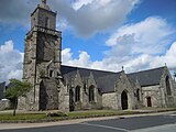 The parish church
 -
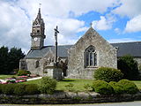 The church Saint Corentin in Trégornan village
 -
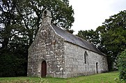
 Chapel Saint Conogan
 -
 Chapel Sainte Christine
 -
 Ossuary in Trégornan village


Civil heritage
-
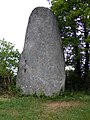 Standing stone in village centre
 -
 Coatcouraval castle
 -
 The village hall
 -
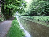 The big trench (canal de Nantes à Brest)


See also
References
- ^ "Répertoire national des élus: les maires" (in French). data.gouv.fr, Plateforme ouverte des données publiques françaises. 30 November 2023.
- ^ "Populations légales 2021". The National Institute of Statistics and Economic Studies. 28 December 2023.
- ^ Des villages de Cassini aux communes d'aujourd'hui: Commune data sheet Glomel, EHESS (in French).
- ^ Population en historique depuis 1968, INSEE
- ^ (in French) Ofis ar Brezhoneg: Enseignement bilingue
External links
Wikimedia Commons has media related to Glomel.
- Base Mérimée: Search for heritage in the commune, Ministère français de la Culture. (in French)
- v
- t
- e

- Allineuc
- Andel
- Aucaleuc
- Beaussais-sur-Mer
- Bégard
- Belle-Isle-en-Terre
- Berhet
- Binic-Étables-sur-Mer
- Bobital
- Le Bodéo
- Bon Repos sur Blavet
- Boqueho
- La Bouillie
- Bourbriac
- Bourseul
- Bréhand
- Brélidy
- Bringolo
- Broons
- Brusvily
- Bulat-Pestivien
- Calanhel
- Callac
- Calorguen
- Le Cambout
- Camlez
- Canihuel
- Caouënnec-Lanvézéac
- Carnoët
- Caulnes
- Caurel
- Cavan
- Les Champs-Géraux
- La Chapelle-Blanche
- La Chapelle-Neuve
- Châtelaudren-Plouagat
- La Chèze
- Coadout
- Coatascorn
- Coatréven
- Coëtlogon
- Coëtmieux
- Cohiniac
- Corlay
- Corseul
- Créhen
- Dinansubpr
- Duault
- Éréac
- Erquy
- Évran
- Le Faouët
- Le Fœil
- Fréhel
- Gausson
- Glomel
- Gomené
- Gommenec'h
- Gouarec
- Goudelin
- Grâces
- Grâce-Uzel
- Guenroc
- Guerlédan
- Guingampsubpr
- Guitté
- Gurunhuel
- La Harmoye
- Le Haut-Corlay
- Hémonstoir
- Hénanbihen
- Hénansal
- Hénon
- Hillion
- Le Hinglé
- Île-de-Bréhat
- Illifaut
- Jugon-les-Lacs
- Kerbors
- Kerfot
- Kergrist-Moëlou
- Kerien
- Kermaria-Sulard
- Kermoroc'h
- Kerpert
- Lamballe-Armor
- Lancieux
- Landebaëron
- Landébia
- La Landec
- Landéhen
- Lanfains
- Langoat
- Langrolay-sur-Rance
- Languédias
- Languenan
- Langueux
- Lanleff
- Lanloup
- Lanmérin
- Lanmodez
- Lannebert
- Lannionsubpr
- Lanrelas
- Lanrivain
- Lanrodec
- Lantic
- Lanvallay
- Lanvellec
- Lanvollon
- Laurenan
- Lescouët-Gouarec
- Le Leslay
- Lézardrieux
- Locarn
- Loc-Envel
- Loguivy-Plougras
- Lohuec
- Loscouët-sur-Meu
- Louannec
- Louargat
- Loudéac
- Maël-Carhaix
- Maël-Pestivien
- Magoar
- La Malhoure
- Mantallot
- Matignon
- La Méaugon
- Mégrit
- Mellionnec
- Le Mené
- Merdrignac
- Mérillac
- Merléac
- Le Merzer
- Minihy-Tréguier
- Moncontour
- La Motte
- Moustéru
- Le Moustoir
- Noyal
- Pabu
- Paimpol
- Paule
- Pédernec
- Penguily
- Penvénan
- Perros-Guirec
- Peumerit-Quintin
- Plaine-Haute
- Plaintel
- Plancoët
- Pléboulle
- Plédéliac
- Plédran
- Pléguien
- Pléhédel
- Plélan-le-Petit
- Plélauff
- Plélo
- Plémet
- Plémy
- Plénée-Jugon
- Pléneuf-Val-André
- Plérin
- Plerneuf
- Plésidy
- Pleslin-Trigavou
- Plestan
- Plestin-les-Grèves
- Pleubian
- Pleudaniel
- Pleudihen-sur-Rance
- Pleumeur-Bodou
- Pleumeur-Gautier
- Pléven
- Plévenon
- Plévin
- Plœuc-l'Hermitage
- Ploëzal
- Plorec-sur-Arguenon
- Plouaret
- Plouasne
- Ploubazlanec
- Ploubezre
- Plouëc-du-Trieux
- Plouër-sur-Rance
- Plouézec
- Ploufragan
- Plougonver
- Plougras
- Plougrescant
- Plouguenast-Langast
- Plouguernével
- Plouguiel
- Plouha
- Plouisy
- Ploulec'h
- Ploumagoar
- Ploumilliau
- Plounérin
- Plounévez-Moëdec
- Plounévez-Quintin
- Plourac'h
- Plourhan
- Plourivo
- Plouvara
- Plouzélambre
- Pludual
- Pluduno
- Plufur
- Plumaudan
- Plumaugat
- Plumieux
- Plurien
- Plusquellec
- Plussulien
- Pluzunet
- Pommeret
- Pommerit-le-Vicomte
- Pont-Melvez
- Pontrieux
- Pordic
- Prat
- La Prénessaye
- Quemper-Guézennec
- Quemperven
- Quessoy
- Quévert
- Le Quillio
- Quintenic
- Quintin
- Le Quiou
- La Roche-Jaudy
- Rospez
- Rostrenen
- Rouillac
- Ruca
- Runan
- Saint-Adrien
- Saint-Agathon
- Saint-Alban
- Saint-André-des-Eaux
- Saint-Barnabé
- Saint-Bihy
- Saint-Brandan
- Saint-Brieucpref
- Saint-Caradec
- Saint-Carné
- Saint-Carreuc
- Saint-Cast-le-Guildo
- Saint-Clet
- Saint-Connan
- Saint-Connec
- Saint-Denoual
- Saint-Donan
- Saint-Étienne-du-Gué-de-l'Isle
- Sainte-Tréphine
- Saint-Fiacre
- Saint-Gildas
- Saint-Gilles-les-Bois
- Saint-Gilles-Pligeaux
- Saint-Gilles-Vieux-Marché
- Saint-Glen
- Saint-Hélen
- Saint-Hervé
- Saint-Igeaux
- Saint-Jacut-de-la-Mer
- Saint-Jean-Kerdaniel
- Saint-Jouan-de-l'Isle
- Saint-Judoce
- Saint-Julien
- Saint-Juvat
- Saint-Launeuc
- Saint-Laurent
- Saint-Lormel
- Saint-Maden
- Saint-Martin-des-Prés
- Saint-Maudan
- Saint-Maudez
- Saint-Mayeux
- Saint-Méloir-des-Bois
- Saint-Michel-de-Plélan
- Saint-Michel-en-Grève
- Saint-Nicodème
- Saint-Nicolas-du-Pélem
- Saint-Péver
- Saint-Pôtan
- Saint-Quay-Perros
- Saint-Quay-Portrieux
- Saint-Rieul
- Saint-Samson-sur-Rance
- Saint-Servais
- Saint-Thélo
- Saint-Trimoël
- Saint-Vran
- Senven-Léhart
- Sévignac
- Squiffiec
- Taden
- Tonquédec
- Tramain
- Trébédan
- Trébeurden
- Trébrivan
- Trébry
- Trédaniel
- Trédarzec
- Trédias
- Trédrez-Locquémeau
- Tréduder
- Treffrin
- Tréfumel
- Trégastel
- Tréglamus
- Trégomeur
- Trégonneau
- Trégrom
- Trégueux
- Tréguidel
- Tréguier
- Trélévern
- Trélivan
- Trémargat
- Trémel
- Tréméreuc
- Trémeur
- Tréméven
- Trémorel
- Trémuson
- Tréogan
- Tressignaux
- Trévé
- Tréveneuc
- Trévérec
- Trévou-Tréguignec
- Trévron
- Trézény
- Troguéry
- Uzel
- La Vicomté-sur-Rance
- Le Vieux-Bourg
- Le Vieux-Marché
- Vildé-Guingalan
- Yffiniac
- Yvias
- Yvignac-la-Tour
- pref: prefecture
- subpr: subprefecture
Authority control databases | |
|---|---|
| International |
|
| National |
|
| Other |
|
 | This Côtes-d'Armor geographical article is a stub. You can help Wikipedia by expanding it. |
- v
- t
- e


