Gouhenans
Commune in Bourgogne-Franche-Comté, France

Coat of arms
Location of Gouhenans

47°36′28″N 6°28′12″E / 47.6078°N 6.47°E / 47.6078; 6.47
1
(2021)[1]
70271 /70110
Gouhenans is a commune in the Haute-Saône department in the region of Bourgogne-Franche-Comté in eastern France.
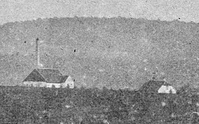
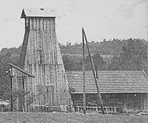
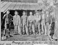
Coal mines were operated in the village between 1828 and 1916.[2]
-
 Mine shaft 4.
 -
 Mine shaft 13.
 -
 Mine shaft 17.


Salt mines were operating in the village between 1831 and 1945. A chemical factory (1844-1955) and a glass factory (1903-1912) were added to the complex.

Salina | Chemical factory |
Glass factory | Administrative offices |
See also
References
- ^ "Populations légales 2021". The National Institute of Statistics and Economic Studies. 28 December 2023.
- ^ Pierre Semonin, Le gîte houiller de Villafans, 1993
Wikimedia Commons has media related to Gouhenans.
- v
- t
- e

- Abelcourt
- Aboncourt-Gesincourt
- Achey
- Adelans-et-le-Val-de-Bithaine
- Aillevans
- Aillevillers-et-Lyaumont
- Ailloncourt
- Ainvelle
- Aisey-et-Richecourt
- Alaincourt
- Amage
- Amance
- Ambiévillers
- Amblans-et-Velotte
- Amoncourt
- Amont-et-Effreney
- Anchenoncourt-et-Chazel
- Ancier
- Andelarre
- Andelarrot
- Andornay
- Angirey
- Anjeux
- Apremont
- Arbecey
- Arc-lès-Gray
- Argillières
- Aroz
- Arpenans
- Arsans
- Athesans-Étroitefontaine
- Attricourt
- Augicourt
- Aulx-lès-Cromary
- Autet
- Authoison
- Autoreille
- Autrey-lès-Cerre
- Autrey-lès-Gray
- Autrey-le-Vay
- Auvet-et-la-Chapelotte
- Auxon
- Avrigney-Virey
- Les Aynans
- Baignes
- Bard-lès-Pesmes
- Barges
- La Barre
- La Basse-Vaivre
- Bassigney
- Les Bâties
- Battrans
- Baudoncourt
- Baulay
- Bay
- Beaujeu-Saint-Vallier-Pierrejux-et-Quitteur
- Beaumotte-Aubertans
- Beaumotte-lès-Pin
- Belfahy
- Belmont
- Belonchamp
- Belverne
- Besnans
- Betaucourt
- Betoncourt-lès-Brotte
- Betoncourt-Saint-Pancras
- Betoncourt-sur-Mance
- Beulotte-Saint-Laurent
- Beveuge
- Blondefontaine
- Bonboillon
- Bonnevent-Velloreille
- Borey
- Bougey
- Bougnon
- Bouhans-et-Feurg
- Bouhans-lès-Lure
- Bouhans-lès-Montbozon
- Bouligney
- Boulot
- Boult
- Bourbévelle
- Bourguignon-lès-Conflans
- Bourguignon-lès-la-Charité
- Bourguignon-lès-Morey
- Boursières
- Bousseraucourt
- Bresilley
- Breuches
- Breuchotte
- Breurey-lès-Faverney
- Brevilliers
- Briaucourt
- Brotte-lès-Luxeuil
- Brotte-lès-Ray
- Broye-Aubigney-Montseugny
- Broye-les-Loups-et-Verfontaine
- Brussey
- La Bruyère
- Bucey-lès-Gy
- Bucey-lès-Traves
- Buffignécourt
- Bussières
- Buthiers
- Calmoutier
- Cemboing
- Cenans
- Cendrecourt
- Cerre-lès-Noroy
- Chagey
- Châlonvillars
- Chambornay-lès-Bellevaux
- Chambornay-lès-Pin
- Champagney
- Champey
- Champlitte
- Champtonnay
- Champvans
- Chancey
- Chantes
- La Chapelle-lès-Luxeuil
- La Chapelle-Saint-Quillain
- Charcenne
- Chargey-lès-Gray
- Chargey-lès-Port
- Chariez
- Charmes-Saint-Valbert
- Charmoille
- Chassey-lès-Montbozon
- Chassey-lès-Scey
- Châteney
- Châtenois
- Chaumercenne
- Chauvirey-le-Châtel
- Chauvirey-le-Vieil
- Chaux-la-Lotière
- Chaux-lès-Port
- Chavanne
- Chemilly
- Chenebier
- Chenevrey-et-Morogne
- Chevigney
- Choye
- Cintrey
- Cirey
- Citers
- Citey
- Clairegoutte
- Clans
- Cognières
- Coisevaux
- Colombe-lès-Vesoul
- Colombier
- Colombotte
- Combeaufontaine
- Comberjon
- Conflandey
- Conflans-sur-Lanterne
- Confracourt
- Contréglise
- Corbenay
- La Corbière
- Cordonnet
- Cornot
- Corravillers
- Corre
- La Côte
- Coulevon
- Courchaton
- Courcuire
- Courmont
- Courtesoult-et-Gatey
- Couthenans
- Cresancey
- La Creuse
- Crevans-et-la-Chapelle-lès-Granges
- Creveney
- Cromary
- Cubry-lès-Faverney
- Cugney
- Cult
- Cuve
- Dambenoît-lès-Colombe
- Dampierre-lès-Conflans
- Dampierre-sur-Linotte
- Dampierre-sur-Salon
- Dampvalley-lès-Colombe
- Dampvalley-Saint-Pancras
- Delain
- Demangevelle
- La Demie
- Denèvre
- Échavanne
- Échenans-sous-Mont-Vaudois
- Échenoz-la-Méline
- Échenoz-le-Sec
- Écromagny
- Écuelle
- Éhuns
- Équevilley
- Errevet
- Esboz-Brest
- Esmoulières
- Esmoulins
- Esprels
- Essertenne-et-Cecey
- Étobon
- Étrelles-et-la-Montbleuse
- Étuz
- Fahy-lès-Autrey
- Fallon
- Faucogney-et-la-Mer
- Faverney
- Faymont
- Fédry
- Ferrières-lès-Ray
- Ferrières-lès-Scey
- Les Fessey
- Filain
- Flagy
- Fleurey-lès-Faverney
- Fleurey-lès-Lavoncourt
- Fleurey-lès-Saint-Loup
- Fondremand
- Fontaine-lès-Luxeuil
- Fontenois-la-Ville
- Fontenois-lès-Montbozon
- Fouchécourt
- Fougerolles-Saint-Valbert
- Fouvent-Saint-Andoche
- Frahier-et-Chatebier
- Framont
- Francalmont
- Franchevelle
- Francourt
- Frasne-le-Château
- Frédéric-Fontaine
- Fresne-Saint-Mamès
- Fresse
- Fretigney-et-Velloreille
- Froideconche
- Froideterre
- Frotey-lès-Lure
- Frotey-lès-Vesoul
- Genevreuille
- Genevrey
- Georfans
- Germigney
- Gevigney-et-Mercey
- Gézier-et-Fontenelay
- Girefontaine
- Gouhenans
- Gourgeon
- Grammont
- Grandecourt
- La Grande-Résie
- Grandvelle-et-le-Perrenot
- Granges-la-Ville
- Granges-le-Bourg
- Grattery
- Gray
- Gray-la-Ville
- Gy
- Haut-du-Them-Château-Lambert
- Hautevelle
- Héricourt
- Hugier
- Hurecourt
- Hyet
- Igny
- Jasney
- Jonvelle
- Jussey
- Lambrey
- Lantenot
- La Lanterne-et-les-Armonts
- Larians-et-Munans
- Larret
- Lavigney
- Lavoncourt
- Lieffrans
- Lieucourt
- Liévans
- Linexert
- Lœuilley
- Lomont
- Longevelle
- La Longine
- Loulans-Verchamp
- Luresubpr
- Luxeuil-les-Bains
- Luze
- Lyoffans
- Magnivray
- Magnoncourt
- Le Magnoray
- Les Magny
- Magny-Danigon
- Magny-Jobert
- Magny-lès-Jussey
- Magny-Vernois
- Mailleroncourt-Charette
- Mailleroncourt-Saint-Pancras
- Mailley-et-Chazelot
- Maizières
- La Malachère
- Malans
- Malbouhans
- Malvillers
- Mandrevillars
- Mantoche
- Marast
- Marnay
- Maussans
- Mélecey
- Melin
- Melincourt
- Mélisey
- Membrey
- Menoux
- Mercey-sur-Saône
- Mersuay
- Meurcourt
- Mignavillers
- Moffans-et-Vacheresse
- Moimay
- Molay
- Mollans
- La Montagne
- Montagney
- Montarlot-lès-Rioz
- Montboillon
- Montbozon
- Montcey
- Montcourt
- Montdoré
- Montessaux
- Montigny-lès-Cherlieu
- Montigny-lès-Vesoul
- Montjustin-et-Velotte
- Mont-le-Vernois
- Montot
- Mont-Saint-Léger
- Montureux-et-Prantigny
- Montureux-lès-Baulay
- Motey-Besuche
- Nantilly
- Navenne
- Neurey-en-Vaux
- Neurey-lès-la-Demie
- Neuvelle-lès-Cromary
- Neuvelle-lès-la-Charité
- La Neuvelle-lès-Lure
- La Neuvelle-lès-Scey
- Noidans-le-Ferroux
- Noidans-lès-Vesoul
- Noiron
- Noroy-le-Bourg
- Oigney
- Oiselay-et-Grachaux
- Onay
- Oppenans
- Oricourt
- Ormenans
- Ormoiche
- Ormoy
- Ouge
- Ovanches
- Oyrières
- Palante
- Passavant-la-Rochère
- Pennesières
- Percey-le-Grand
- Perrouse
- Pesmes
- Pierrecourt
- Pin
- La Pisseure
- Plainemont
- Plancher-Bas
- Plancher-les-Mines
- Polaincourt-et-Clairefontaine
- Pomoy
- Pontcey
- Pont-du-Bois
- Pont-sur-l'Ognon
- Port-sur-Saône
- Poyans
- Preigney
- La Proiselière-et-Langle
- Provenchère
- Purgerot
- Pusey
- Pusy-et-Épenoux
- La Quarte
- Quenoche
- Quers
- Quincey
- Raddon-et-Chapendu
- Raincourt
- Ranzevelle
- Ray-sur-Saône
- Raze
- Recologne
- Recologne-lès-Rioz
- Renaucourt
- La Résie-Saint-Martin
- Rignovelle
- Rigny
- Rioz
- Roche-et-Raucourt
- La Rochelle
- La Roche-Morey
- Roche-sur-Linotte-et-Sorans-les-Cordiers
- La Romaine
- Ronchamp
- Rosey
- La Rosière
- Rosières-sur-Mance
- Roye
- Ruhans
- Rupt-sur-Saône
- Saint-Barthélemy
- Saint-Bresson
- Saint-Broing
- Sainte-Marie-en-Chanois
- Sainte-Marie-en-Chaux
- Sainte-Reine
- Saint-Ferjeux
- Saint-Gand
- Saint-Germain
- Saint-Loup-Nantouard
- Saint-Loup-sur-Semouse
- Saint-Marcel
- Saint-Rémy-en-Comté
- Saint-Sauveur
- Saint-Sulpice
- Saponcourt
- Saulnot
- Saulx
- Sauvigney-lès-Gray
- Sauvigney-lès-Pesmes
- Savoyeux
- Scey-sur-Saône-et-Saint-Albin
- Scye
- Secenans
- Selles
- Semmadon
- Senargent-Mignafans
- Senoncourt
- Servance-Miellin
- Servigney
- Seveux-Motey
- Soing-Cubry-Charentenay
- Sorans-lès-Breurey
- Sornay
- Tartécourt
- Ternuay-Melay-et-Saint-Hilaire
- Theuley
- Thieffrans
- Thiénans
- Tincey-et-Pontrebeau
- Traitiéfontaine
- Traves
- Le Tremblois
- Trémoins
- Trésilley
- Tromarey
- Vadans
- Vaite
- La Vaivre
- Vaivre-et-Montoille
- Valay
- Le Val-de-Gouhenans
- Vallerois-le-Bois
- Vallerois-Lorioz
- Le Val-Saint-Éloi
- Vandelans
- Vanne
- Vantoux-et-Longevelle
- Varogne
- Vars
- Vauchoux
- Vauconcourt-Nervezain
- Vauvillers
- Vaux-le-Moncelot
- Velesmes-Échevanne
- Velet
- Vellechevreux-et-Courbenans
- Velleclaire
- Vellefaux
- Vellefrey-et-Vellefrange
- Vellefrie
- Velleguindry-et-Levrecey
- Velle-le-Châtel
- Velleminfroy
- Vellemoz
- Vellexon-Queutrey-et-Vaudey
- Velloreille-lès-Choye
- Velorcey
- Venère
- Venisey
- Vereux
- La Vergenne
- Verlans
- Vernois-sur-Mance
- La Vernotte
- Vesoulpref
- Villafans
- Villargent
- Villars-le-Pautel
- La Villedieu-en-Fontenette
- Villefrancon
- La Villeneuve-Bellenoye-et-la-Maize
- Villeparois
- Villers-Bouton
- Villers-Chemin-et-Mont-lès-Étrelles
- Villersexel
- Villers-la-Ville
- Villers-le-Sec
- Villers-lès-Luxeuil
- Villers-Pater
- Villers-sur-Port
- Villers-sur-Saulnot
- Villers-Vaudey
- Vilory
- Visoncourt
- Vitrey-sur-Mance
- La Voivre
- Volon
- Voray-sur-l'Ognon
- Vougécourt
- Vouhenans
- Vregille
- Vyans-le-Val
- Vy-le-Ferroux
- Vy-lès-Filain
- Vy-lès-Lure
- Vy-lès-Rupt
- pref: prefecture
- subpr: subprefecture
| Authority control databases: National |
|
|---|
 | This Haute-Saône geographical article is a stub. You can help Wikipedia by expanding it. |
- v
- t
- e


