Grade I and II* listed buildings in the London Borough of Wandsworth
Map all coordinates using OpenStreetMap
Download coordinates as:
- KML
- GPX (all coordinates)
- GPX (primary coordinates)
- GPX (secondary coordinates)
There are over 9,000 Grade I listed buildings and 20,000 Grade II* listed buildings in England. This page is a list of these buildings in the London Borough of Wandsworth.
Grade I
| Name | Location | Type | Completed [note 1] | Date designated | Grid ref.[note 2] Geo-coordinates | Entry number [note 3] | Image |
|---|---|---|---|---|---|---|---|
| Church of St Mary and Churchyard Wall and Gates | Battersea, Wandsworth | Church | 1775–77 | 28 June 1954 | TQ2680676866 51°28′36″N 0°10′32″W / 51.476551°N 0.175472°W / 51.476551; -0.175472 (Church of St Mary and Churchyard Wall and Gates) | 1357626 |  More images |
| Gala Bingo Club (Granada Cinema) | Tooting, Wandsworth | Bingo Hall | 1931 | 28 June 1972 | TQ2752071310 51°25′35″N 0°10′02″W / 51.426459°N 0.167198°W / 51.426459; -0.167198 (Gala Bingo Club (Granada Cinema)) | 1357668 |  More images |
| Mount Clare | Wandsworth | House | 1772 | 14 July 1955 | TQ2162374004 51°27′07″N 0°15′04″W / 51.451966°N 0.25105°W / 51.451966; -0.25105 (Mount Clare) | 1184436 | 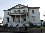 More images |
| Parkstead House | Roehampton University, Roehampton Lane, Wandsworth | House | 1760 | 14 July 1955 | TQ2216773650 51°26′55″N 0°14′36″W / 51.448667°N 0.243347°W / 51.448667; -0.243347 (Parkstead House) | 1357675 |  More images |
| Roehampton House (at Queen Mary's Hospital) | Roehampton, Wandsworth | House | 1710–12 | 23 October 1978 | TQ2221074260 51°27′15″N 0°14′33″W / 51.45414°N 0.242518°W / 51.45414; -0.242518 (Roehampton House (at Queen Mary's Hospital)) | 1357694 |  More images |
Grade II*
| Name | Location | Type | Completed [note 1] | Date designated | Grid ref.[note 2] Geo-coordinates | Entry number [note 3] | Image |
|---|---|---|---|---|---|---|---|
| Albert Bridge | Wandsworth | Suspension Bridge | 1873 | 8 February 1975 | TQ2741277472 51°28′55″N 0°10′00″W / 51.481861°N 0.166533°W / 51.481861; -0.166533 (Albert Bridge) | 1065576 | 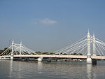 More images |
| Battersea Arts Centre (formerly Battersea Town Hall) | Clapham, Wandsworth | Assembly Hall | 1892 | 13 February 1970 | TQ2785775629 51°27′55″N 0°09′39″W / 51.465198°N 0.160794°W / 51.465198; -0.160794 (Battersea Arts Centre (formerly Battersea Town Hall)) | 1184293 |  More images |
| Battersea Power Station | Wandsworth | Power station | 1937–1941 | 14 October 1980 | TQ2894577506 51°28′55″N 0°08′40″W / 51.481819°N 0.144456°W / 51.481819; -0.144456 (Battersea Power Station) | 1357620 | 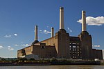 More images |
| Binley House | Wandsworth | Flats | 1955–1958 | 22 December 1998 | TQ2201474194 51°27′13″N 0°14′43″W / 51.453589°N 0.24536°W / 51.453589; -0.24536 (Binley House) | 1246040 |  |
| Charcot House | Wandsworth | Flats | 1955–1958 | 22 December 1998 | TQ2187174207 51°27′13″N 0°14′51″W / 51.453737°N 0.247412°W / 51.453737; -0.247412 (Charcot House) | 1246043 | |
| All Saints' Church, Putney Common | Wandsworth | Church | 1874 | 26 February 1976 | TQ2313075730 51°28′02″N 0°13′44″W / 51.467152°N 0.228772°W / 51.467152; -0.228772 (All Saints' Church, Putney Common) | 1065542 |  More images |
| All Saints Church, Wandsworth | Wandsworth | Church | 1630 | 14 July 1955 | TQ2547574720 51°27′27″N 0°11′43″W / 51.457561°N 0.195389°W / 51.457561; -0.195389 (All Saints Church, Wandsworth) | 1357684 |  More images |
| Church of Holy Trinity | Roehampton, Wandsworth | Church | 1896 TO 1898 | 14 July 1955 | TQ2259573720 51°26′57″N 0°14′14″W / 51.449204°N 0.237166°W / 51.449204; -0.237166 (Church of Holy Trinity) | 1357671 | 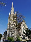 More images |
| St Anne's Church, Wandsworth | Wandsworth | Parish Church | 1820-4 | 14 July 1955 | TQ2603174446 51°27′18″N 0°11′15″W / 51.454975°N 0.187488°W / 51.454975; -0.187488 (St Anne's Church, Wandsworth) | 1065485 |  More images |
| Church of St Luke | Wandsworth | Church | 1883 | 7 April 1983 | TQ2817674205 51°27′08″N 0°09′24″W / 51.452328°N 0.15672°W / 51.452328; -0.15672 (Church of St Luke) | 1065521 |  More images |
| Church of St Mark | Wandsworth | Anglican Church | 1872-4 | 28 June 1954 | TQ2721475088 51°27′38″N 0°10′13″W / 51.46048°N 0.17024°W / 51.46048; -0.17024 (Church of St Mark) | 1065551 |  More images |
| St. Mary's Church, Putney | Wandsworth | Church | 15th century | 14 July 1955 | TQ2415675601 51°27′57″N 0°12′51″W / 51.465769°N 0.214054°W / 51.465769; -0.214054 (St. Mary's Church, Putney) | 1065519 |  More images |
| Church of St Paul | Wimbledon Park, Wandsworth | Church | 1888–1896 | 14 July 1955 | TQ2389873076 51°26′35″N 0°13′07″W / 51.443133°N 0.21865°W / 51.443133; -0.21865 (Church of St Paul) | 1065578 |  More images |
| Church of the Ascension, Lavender Hill | Clapham, Wandsworth | Church | 1876–83 | 28 June 1954 | TQ2809675666 51°27′56″N 0°09′26″W / 51.465476°N 0.157342°W / 51.465476; -0.157342 (Church of the Ascension, Lavender Hill) | 1065541 |  More images |
| Church Row, 1–6, Wandsworth Plain SW18 | Wandsworth | House | c. 1723 | 14 July 1955 | TQ2551974730 51°27′28″N 0°11′41″W / 51.457641°N 0.194752°W / 51.457641; -0.194752 (Church Row, 1–6, Wandsworth Plain SW18) | 1183550 |  More images |
| Cremorne Bridge, West London Extension Railway Bridge, Battersea | Wandsworth | Railway Bridge | 1863 | 26 November 2008 | TQ2661876442 51°28′22″N 0°10′42″W / 51.472782°N 0.17833°W / 51.472782; -0.17833 (Cremorne Bridge, West London Extension Railway Bridge, Battersea) | 1393005 |  More images |
| Denmead House | Wandsworth | Flats | 1955–1958 | 22 December 1998 | TQ2180274216 51°27′14″N 0°14′54″W / 51.453833°N 0.248402°W / 51.453833; -0.248402 (Denmead House) | 1246044 | |
| Devonshire House including Railings and Gates, 44 Vicarage Crescent | Wandsworth | House | Early 18th century | 28 June 1954 | TQ2678676645 51°28′28″N 0°10′33″W / 51.474569°N 0.175839°W / 51.474569; -0.175839 (Devonshire House including Railings and Gates, 44 Vicarage Crescent) | 1357666 |  More images |
| Dixcote | Wandsworth | House | 1897 | 7 April 1983 | TQ2917371793 51°25′50″N 0°08′36″W / 51.430426°N 0.143259°W / 51.430426; -0.143259 (Dixcote) | 1065512 |  Upload Photo |
| Downshire House | Roehampton, Wandsworth | House | c. 1770 | 14 July 1955 | TQ2208874120 51°27′10″N 0°14′40″W / 51.452908°N 0.244321°W / 51.452908; -0.244321 (Downshire House) | 1065522 |  More images |
| Dunbridge House | Wandsworth | Flats | 1955–1958 | 22 December 1998 | TQ2173474225 51°27′14″N 0°14′58″W / 51.453928°N 0.249377°W / 51.453928; -0.249377 (Dunbridge House) | 1246042 | |
| Granada Theatre, Clapham Junction (former Granada Theatre, former Gala Bingo Hall) | St John's Hill, Clapham Junction | Cafe | 1937 | 1 May 1998 | TQ2699675264 51°27′44″N 0°10′24″W / 51.462111°N 0.173313°W / 51.462111; -0.173313 (Granada Theatre, Clapham Junction (former Granada Theatre, former Gala Bingo Hall)) | 1119730 |  More images |
| Former Royal Victoria Patriotic School | Wandsworth | Courtyard | 1857-9 | 3 October 1973 | TQ2693474283 51°27′12″N 0°10′28″W / 51.453309°N 0.174557°W / 51.453309; -0.174557 (Former Royal Victoria Patriotic School) | 1065496 | 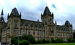 More images |
| Grove House | Roehampton, Wandsworth | House | 1777 | 14 July 1955 | TQ2198274367 51°27′19″N 0°14′45″W / 51.455151°N 0.245761°W / 51.455151; -0.245761 (Grove House) | 1065523 | 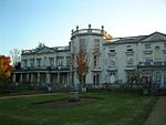 More images |
| Old Battersea House, 30 Vicarage Crescent | Wandsworth | House | c. 1699 | 28 June 1954 | TQ2674776575 51°28′26″N 0°10′35″W / 51.473949°N 0.176426°W / 51.473949; -0.176426 (Old Battersea House, 30 Vicarage Crescent) | 1065500 |  More images |
| Ram (Youngs) Brewery Complex | Wandsworth | Brewery | Late 18th century | 14 July 1955 | TQ2565174685 51°27′26″N 0°11′34″W / 51.457207°N 0.192869°W / 51.457207; -0.192869 (Ram (Youngs) Brewery Complex) | 1065461 |  More images |
| 'Single Form (Memorial)' | Battersea Park | Memorial | 19 January 2016 | TQ2837576995 51°28′38″N 0°09′10″W / 51.477357°N 0.15284563°W / 51.477357; -0.15284563 ('Single Form (Memorial)') | 1430770 |  More images | |
| Tomb of Robert Wood, Putney Old Burial Ground | Putney Old Burial Ground | Table Tomb | LATER 18th century | 7 April 1983 | TQ2370575121 51°27′42″N 0°13′15″W / 51.461554°N 0.220711°W / 51.461554; -0.220711 (Tomb of Robert Wood, Putney Old Burial Ground) | 1065497 | 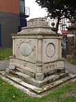 More images |
| Temple in Grounds of Mount Clare | Wandsworth | Garden Temple | 1762–69 | 14 June 1955 | TQ2170673855 51°27′02″N 0°15′00″W / 51.450609°N 0.249907°W / 51.450609; -0.249907 (Temple in Grounds of Mount Clare) | 1065545 | Upload Photo |
| The Bull at Foot of Downshire Field Alton Estate | Daneburry Avenue, Roehampton, London SW15 | Sculpture | 1961 | 15 April 1998 | TQ2183874029 51°27′08″N 0°14′53″W / 51.452144°N 0.247948°W / 51.452144; -0.247948 (The Bull at Foot of Downshire Field Alton Estate) | 1376742 |  More images |
| War Memorial of the 24th East Surrey Division, Battersea Park | Battersea Park, Wandsworth | War Memorial | 1924 | 24 August 2005 | TQ2829677344 51°28′50″N 0°09′14″W / 51.480511°N 0.153856°W / 51.480511; -0.153856 (War Memorial of the 24th East Surrey Division, Battersea Park) | 1391503 | 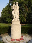 More images |
| Winchfield House and Abutting Chimney | Wandsworth | Flats | 1955–1958 | 22 December 1998 | TQ2193874196 51°27′13″N 0°14′47″W / 51.453624°N 0.246452°W / 51.453624; -0.246452 (Winchfield House and Abutting Chimney) | 1246041 |  |
| 174 and 176 East Hill, SW18 | 170 East Hill, Wandsworth Town, SW18 2HD | House | c. 1736 | 14 July 1955 | TQ2598474708 51°27′26″N 0°11′17″W / 51.45734°N 0.188071°W / 51.45734; -0.188071 (174 and 176 East Hill, SW18) | 1357641 |  |
See also
Notes
- ^ a b The date given is the date used by Historic England as significant for the initial building or that of an important part in the structure's description.
- ^ a b Sometimes known as OSGB36, the grid reference is based on the British national grid reference system used by the Ordnance Survey.
- ^ a b The "List Entry Number" is a unique number assigned to each listed building and scheduled monument by Historic England.
External links
 Media related to Grade I listed buildings in the London Borough of Wandsworth at Wikimedia Commons
- Media related to Grade II* listed buildings in the London Borough of Wandsworth at Wikimedia Commons
- v
- t
- e
- Balham
- Battersea
- Clapham
- Earlsfield
- Furzedown
- Nine Elms
- Putney
- Putney Heath
- Putney Vale
- Roehampton
- Southfields
- Streatham Park
- Summerstown
- Tooting (including Tooting Graveney and Upper Tooting)
- Wandsworth
- West Hill


- Battersea Arts Centre
- Battersea Power Station
- Bridge Lane Theatre
- Chrysalis Theatre
- De Morgan Centre
- Grace Theatre
- New Covent Garden Market
- New Wandsworth Museum
- Pump House Gallery
- Theatre503
- Theatre of the Dispossessed
- Battersea
- Putney
- Tooting

 Balham
- Battersea Park
- Battersea Power Station
-
 Clapham Junction
 - Clapham South
- Earlsfield
- East Putney
- Nine Elms
- Putney
- Queenstown Road (Battersea)
- Southfields
- Tooting (in LB of Merton)
- Tooting Bec
- Tooting Broadway
- Wandsworth Common
- Wandsworth Town


- Council
- Listed buildings
- Grade I and II*
- Grade II
- People
- Public art
- Schools
 Category
- Commons

Portals:
 London
 Architecture


