Great Shunner Fell
Mountain in Cumbria, England


Great Shunner Fell
North Yorkshire, England
Great Shunner Fell is the third-highest mountain in the Yorkshire Dales, North Yorkshire, England, and the highest point in Wensleydale;[1] at 716 metres above sea level. In clear weather the summit affords views of Wensleydale to the south, Ribblesdale to the southwest and Swaledale to the north, as well as views into Cumbria and County Durham beyond the A66.
The Pennine Way passes over its summit, on the way from Hawes to Keld. The popularity of this route had eroded vegetation from a strip 70 m wide across the moor, which has been alleviated since 1996 by the construction of a path made of flagstones.[2]
The summit holds a cross-shaped windbreak of which the triangulation pillar has been built into the northern 'arm'.
Great Sleddale Beck, which becomes the River Swale after its confluence with Birkdale Beck, has its sources on the northern slopes of Great Shunner Fell, while the southern slopes drain into the River Ure and Wensleydale.
The dominating rock type in the area is limestone, but millstone grit outcrops extensively on Great Shunner Fell, and coal seams have also been worked on its slopes.[3]
Great Shunner Fell is the most southerly remaining outpost in Great Britain for the yellow marsh saxifrage, Saxifraga hirculus.[4]
Gallery
-
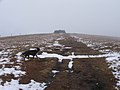 The last few yards to the summit
 -
 The summit plateau of Great Shunner Fell viewed from the south


See also
References
- ^ "Cotterdale and Great Shunner Fell". Dalesman.co.uk. December 2003.
- ^ "Pennine Way". Yorkshire Dales National Park Authority. 2006. Archived from the original on 28 September 2007. Retrieved 14 April 2007.
- ^ "Wensleydale character areas". Yorkshire Dales National Park Authority. 2006. Archived from the original on 8 March 2007. Retrieved 14 April 2007.
- ^ "Yellow marsh saxifrage Saxifaga hirculus species action plan" (PDF). Yorkshire Dales National Park Authority. Archived from the original (PDF) on 28 September 2007. Retrieved 14 April 2007.
Wikimedia Commons has media related to Great Shunner Fell.
- v
- t
- e
Hills of the Northern Yorkshire Dales
- Baugh Fell
- Great Shunner Fell
- Hoove
- Kisdon
- Lovely Seat
- Nine Standards Rigg
- Rogan's Seat
- The Calf
- Wild Boar Fell
- Yarlside
- Calders
- Fell Head
- High Seat
- Little Fell
- Randygill Top
- Swarth Fell
- Wether Fell
- Winder
Marilyns of Northern England | ||
|---|---|---|
| 1. Northumberland |  | |
| 2. Northern Lakeland | ||
| 3. Western Lakeland |
| |
| 4. Central and Southern Lakeland | ||
| 5. Eastern Lakeland | ||
| 6. North Pennines and Durham |
| |
| 7. Northern Yorkshire Dales |
| |
| 8. Southern Yorkshire Dales | ||
| 9. North York Moors to the Humber | ||
| 10. Forest of Bowland |
| |
‹ The stub template below has been proposed for deletion. Please share your thoughts at this template's entry on the Categories for discussion page.
 | This Richmondshire location article is a stub. You can help Wikipedia by expanding it. |
- v
- t
- e


