Grey Glacier
Glacier of Chile
50°57′S 73°15′W / 50.950°S 73.250°W / -50.950; -73.250Grey Glacier is a glacier in the Southern Patagonian Ice Field, just west of the Cordillera del Paine. It flows southward into the lake of the same name. Before dividing in two at its front end, the glacier is 6 kilometers wide and over 30 meters high. In 1996, it occupied a total area of 270 km2 (100 sq mi) and a length of 28 km (17 mi).[2] In November 2017 a large iceberg broke off the glacier.[3]
Surroundings


The glacier is at the south end of the Southern Patagonia Ice Field. The surface of the lake can be seen when following the big circuit of Paine Mountain Range at John Garner Pass. There is another view of the glacier from the south shore of the lake where the glacier can be seen in the background, with fragments of ice floating close to the shore. It is located to the west side of the Torres del Paine National Park.
Gallery
-
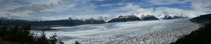 View from the west side
 -
 Icebergs calved by the glacier.


See also
- List of glaciers
References
- ^ a b http://www.glaciologia.cl/spi.html Archived 2012-03-24 at the Wayback Machine
- ^ "Grey Glacier, Chile : Image of the Day". earthobservatory.nasa.gov. 2007-06-04. Retrieved 2018-02-12.
- ^ Guardian Staff; agencies (2017-11-29). "Large iceberg breaks off from Grey glacier in southern Chile". the Guardian. Retrieved 2018-02-12.
External links
 Media related to Grey Glacier at Wikimedia Commons
- Grey Glacier at the NASA Earth Observatory
- See details and pictures of the Navigation to the Grey Glacier.
- v
- t
- e
Hydrography of Magallanes Region
- Azopardo
- Bellavista
- Geike
- Grande
- Grey
- Las Minas
- Paine
- Penitente
- Rubens
- San Juan
- Serrano
- Yendegaia

- Salto Grande


