Hard, Austria
You can help expand this article with text translated from the corresponding article in German. (April 2010) Click [show] for important translation instructions.
- View a machine-translated version of the German article.
- Machine translation, like DeepL or Google Translate, is a useful starting point for translations, but translators must revise errors as necessary and confirm that the translation is accurate, rather than simply copy-pasting machine-translated text into the English Wikipedia.
- Do not translate text that appears unreliable or low-quality. If possible, verify the text with references provided in the foreign-language article.
- You must provide copyright attribution in the edit summary accompanying your translation by providing an interlanguage link to the source of your translation. A model attribution edit summary is
Content in this edit is translated from the existing German Wikipedia article at [[:de:Hard]]; see its history for attribution. - You may also add the template
{{Translated|de|Hard}}to the talk page. - For more guidance, see Wikipedia:Translation.
Place in Vorarlberg, Austria

Coat of arms
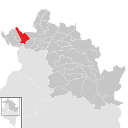
Location in the district
(2018-01-01)[2]
6971
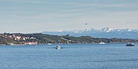
Hard is a town in the west of the westernmost Austrian state of Vorarlberg, directly on the southern shores of Lake Constance. Hard's attractions include the Strandbad and the Grünerdamm. Hard is also known for its skatepark.
An honorary consulate of Brazil is located in Hard.[3]
Population
| Year | Pop. | ±% |
|---|---|---|
| 1869 | 2,305 | — |
| 1880 | 2,085 | −9.5% |
| 1890 | 2,183 | +4.7% |
| 1900 | 2,914 | +33.5% |
| 1910 | 3,637 | +24.8% |
| 1923 | 3,049 | −16.2% |
| 1934 | 3,387 | +11.1% |
| 1939 | 3,488 | +3.0% |
| 1951 | 4,788 | +37.3% |
| 1961 | 6,671 | +39.3% |
| 1971 | 8,887 | +33.2% |
| 1981 | 10,103 | +13.7% |
| 1991 | 10,747 | +6.4% |
| 2001 | 11,471 | +6.7% |
| 2011 | 12,546 | +9.4% |
Geography
Hard has an area of 17.46 km² (6.75 sq mi). Hard is also located between the two rivers Bregenzer Ach and Rhine, and borders on the provincial capital Bregenz.
History
In the 7th century, Alemanni settled near Mittelweiherburg. Near Lake Constance, around the year 1200, large parts of the woods were cleared to build a village: Hard (Old High German for "forest"). The community of Hard was first mentioned in a charter from Pope Innocent IV to the monastery of Mehrerau in 1249.
In 1794, Samuel Vogel from Alsace opened the first Hard textile factory. In 1802, the "Allmenden" (common grounds) were suspended, resulting in private fields, pastures and forests. In 1997, the textile printing museum in Mittelweiherburg was opened.
Harder Schwabenkinder (Swabian children)

From the 17th century to the beginning of the 20th century, many poor Vorarlberg farmers sent their children to Swabia, Southern Germany, to do seasonal work there. These children were called "Schwabenkinder", the undertaking itself was referred to as "Schwabengehen".
Heraldry
The coat of arms of Hard shows two trees and a sailboat. They symbolize important early activities in Hard: logging and fishing.
References
- ^ "Dauersiedlungsraum der Gemeinden Politischen Bezirke und Bundesländer - Gebietsstand 1.1.2018". Statistics Austria. Retrieved 10 March 2019.
- ^ "Einwohnerzahl 1.1.2018 nach Gemeinden mit Status, Gebietsstand 1.1.2018". Statistics Austria. Retrieved 9 March 2019.
- ^ "Foreign representations in Austria". Federal Ministry for European and International Affairs (Austria). Archived from the original on 2011-05-22. Retrieved 2009-01-28.
External links
- Town of Hard
Wikimedia Commons has media related to Hard.
- v
- t
- e

- Alberschwende
- Andelsbuch
- Au
- Bezau
- Bildstein
- Bizau
- Bregenz
- Buch
- Damüls
- Doren
- Egg
- Eichenberg
- Fußach
- Gaißau
- Hard
- Hittisau
- Höchst
- Hohenweiler
- Hörbranz
- Kennelbach
- Krumbach
- Langen bei Bregenz
- Langenegg
- Lauterach
- Lingenau
- Lochau
- Mellau
- Mittelberg
- Möggers
- Reuthe
- Riefensberg
- Schnepfau
- Schoppernau
- Schröcken
- Schwarzach
- Schwarzenberg
- Sibratsgfäll
- Sulzberg
- Warth
- Wolfurt


Authority control databases | |
|---|---|
| International |
|
| National |
|
| Geographic |
|
 | This Vorarlberg location article is a stub. You can help Wikipedia by expanding it. |
- v
- t
- e


