Hyndman Peak


Hyndman Peak
Custer and Blaine Counties, Idaho, U.S.
Show map of Idaho
Hyndman Peak
Hyndman Peak (the United States)
Show map of the United StatesHyndman Peak, at an elevation of 12,012 feet (3,661 m) above sea level, is the ninth highest peak in Idaho and the highest point in the Pioneer Mountains, Sawtooth National Forest, and Blaine County. Hyndman Peak is located on the border of Custer and Blaine counties.[3] The towns of Hailey, Ketchum, and Sun Valley are west of the peak.
The mountain was named after Major William Hyndman, an early settler,[4] and businessperson in the local mining industry.[5] The first recorded ascent of Hyndman Peak was made in 1889 by W. T. Griswold and E. T. Perkins.[6] The primary route to the summit is class 2, which along with its proximity to Sun Valley makes it a popular destination.
The trailhead to hike to Hyndman Peak is located at the end of Sawtooth National Forest road 203 along Hyndman Creek. The primary route is approximately six miles (10 km) one way from the trailhead and traverses through Hyndman Basin, which is bordered by Hyndman, Old Hyndman, and Cobb Peaks.[7] The route follows an unmaintained trail and ascends the Hyndman-Old Hyndman saddle before reaching the summit.
Climate
| Climate data for Hyndman Peak 43.7508 N, 114.1329 W, Elevation: 11,266 ft (3,434 m) (1991–2020 normals) | |||||||||||||
|---|---|---|---|---|---|---|---|---|---|---|---|---|---|
| Month | Jan | Feb | Mar | Apr | May | Jun | Jul | Aug | Sep | Oct | Nov | Dec | Year |
| Mean daily maximum °F (°C) | 20.9 (−6.2) | 20.3 (−6.5) | 24.4 (−4.2) | 29.7 (−1.3) | 39.3 (4.1) | 49.1 (9.5) | 60.6 (15.9) | 60.1 (15.6) | 51.2 (10.7) | 38.2 (3.4) | 25.8 (−3.4) | 20.0 (−6.7) | 36.6 (2.6) |
| Daily mean °F (°C) | 13.3 (−10.4) | 11.8 (−11.2) | 14.9 (−9.5) | 19.2 (−7.1) | 28.0 (−2.2) | 37.0 (2.8) | 47.2 (8.4) | 46.6 (8.1) | 38.2 (3.4) | 27.5 (−2.5) | 18.0 (−7.8) | 12.6 (−10.8) | 26.2 (−3.2) |
| Mean daily minimum °F (°C) | 5.8 (−14.6) | 3.2 (−16.0) | 5.4 (−14.8) | 8.8 (−12.9) | 16.7 (−8.5) | 24.9 (−3.9) | 33.8 (1.0) | 33.2 (0.7) | 25.3 (−3.7) | 16.8 (−8.4) | 10.2 (−12.1) | 5.3 (−14.8) | 15.8 (−9.0) |
| Average precipitation inches (mm) | 4.09 (104) | 3.88 (99) | 3.25 (83) | 3.10 (79) | 3.66 (93) | 2.26 (57) | 1.27 (32) | 1.02 (26) | 2.05 (52) | 3.26 (83) | 2.72 (69) | 5.06 (129) | 35.62 (906) |
| Source: PRISM Climate Group[8] | |||||||||||||
- View from the summit
-

-
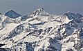 North face, aerial


References
- ^ a b "Hyndman". NGS Data Sheet. National Geodetic Survey, National Oceanic and Atmospheric Administration, United States Department of Commerce. Retrieved 2021-05-27.
- ^ "Hyndman Peak, Idaho". Peakbagger.com. Retrieved 2021-05-27.
- ^ Sawtooth National Forest. "Sawtooth National Forest" [map].1:126,720, 1"=2 miles. Twin Falls, Idaho: Sawtooth National Forest, United States Forest Service, 1998.
- ^ Rees, John E. (1918). Idaho Chronology, Nomenclature, Bibliography. W.B. Conkey Company. p. 78.
- ^ Biennial Report of the Board of Trustees of the State Historical Society of Idaho. Idaho State Historical Society. 1922. p. 19.
- ^ "Idaho 12ers". Idaho 12ers. Retrieved 2011-12-26.
- ^ "Hyndman Peak, ID". High-Powered Planet. Retrieved 2011-12-26.
- ^ "PRISM Climate Group, Oregon State University". PRISM Climate Group, Oregon State University. Retrieved October 2, 2023.
To find the table data on the PRISM website, start by clicking Coordinates (under Location); copy Latitude and Longitude figures from top of table; click Zoom to location; click Precipitation, Minimum temp, Mean temp, Maximum temp; click 30-year normals, 1991-2020; click 800m; click Retrieve Time Series button.
External links
Hyndman Peak at Wikipedia's sister projects
 Definitions from Wiktionary
 Media from Commons
 News from Wikinews
 Quotations from Wikiquote
 Texts from Wikisource
 Textbooks from Wikibooks
 Resources from Wikiversity
- "Thompson Peak". Geographic Names Information System. United States Geological Survey, United States Department of the Interior. Retrieved 2010-02-15.
- Hyndman Peak trip report
- SummitPost.org - HyndmanPeak
- Sawtooth National Forest - Official Site
- Idaho Summits - Hyndman Peak
- Idaho 12ers
- v
- t
- e
- Cache Peak
- Graham Peak
- Mount Harrison
- Mount Independence
- Smoky Mountain
- Thunder Mountain
| Centennial Mountains |
|
|---|---|
| Clearwater Mountains |
- Steel Mountain
- Trinity Mountain
- Two Point Mountain
- Boulder Peak
- Cerro Ciento
- Easley Peak
- Glassford Peak
- Kent Peak
- Ryan Peak
| Selkirk Mountains |
|
|---|
- Bell Mountain
- Big Boy Peak
- Big Creek Peak
- Diamond Peak
- Flatiron Mountain
- Little Diamond Peak
- Nicholson Peak
- The Riddler
- Shoshone John Peak
- Borah Peak
- Donaldson Peak
- Leatherman Peak
- Little Regret Peak
- Lost River Peak
- Mount Breitenbach
- Mount Church
- Mount Idaho
- Mount McCaleb
- No Regret Peak
- USGS Peak
- Altair Peak
- Angel's Perch
- Brocky Peak
- Cobb Peak
- Devils Bedstead East
- Duncan's Peak
- Goat Mountain
- Hyndman Peak
- Old Hyndman Peak
- Pegasus Peak
- Pioneer Mountain
- Pyramid Peak
- Salzburger Spitzl
- Smiley Mountain
- Standhope Peak
- Alpine Peak
- Baron Peak
- Braxon Peak
- Cirque Lake Peak
- Dave's Peak
- Decker Peak
- El Capitan
- Elk Peak
- Grand Mogul
- Horstmann Peak
- Imogene Peak
- McDonald Peak
- McGowan Peak
- Merritt Peak
- Mickey's Spire
- Moolack Mountain
- Monte Verita
- Mount Carter
- Mount Cramer
- Mount Heyburn
- Mount Iowa
- Mount Limbert
- Mount Regan
- North Raker
- Packrat Peak
- Parks Peak (Blaine County)
- Payette Peak
- Sevy Peak
- Snowyside Peak
- Thompson Peak
- Warbonnet Peak
- Williams Peak (Custer County)
- Backdrop Peak
- Baker Peak
- Bald Mountain
- Bear Peak
- Big Peak
- Bromaghin Peak
- Buttercup Mountain
- Camas County Highpoint
- Carbonate Mountain
- Dollarhide Mountain
- Griffin Butte
- Kelly Mountain (Blaine County)
- Lower Titus Peak
- Mahoney Butte
- Norton Peak
- Paradise Peak
- Prairie Creek Peak
- Saviers Peak
- Skillern Peak
- Titus Peak
- Boardman Peak
- Iron Mountain
- Smoky Dome
- Snowbank Mountain
- Bible Back Mountain
- Blackmon Peak
- Calkins Peak
- Castle Peak
- Chinese Wall
- Croseus Peak
- D. O. Lee Peak
- Ebony Peak
- Fourth of July Peak (Custer County)
- Horton Peak
- Lonesome Lake Peak
- Lookout Mountain
- Merriam Peak
- Patterson Peak (Custer County)
- Peak 11,272
- Washington Peak
- Watson Peak (Custer County)
- White Cloud Peak 1
- White Cloud Peak 2
- White Cloud Peak 3
- White Cloud Peak 4
- White Cloud Peak 5
- White Cloud Peak 6
- White Cloud Peak 7
- White Cloud Peak 8
- White Cloud Peak 9
- White Cloud Peak 10
- Bear River Mountains
- Big Dick Point
- Blackfoot Mountains
- Brundage Mountain
- Caribou Mountains
- Chinese Peak
- Cotterel Mountains
- Devils Throne
- Devils Tooth
- Dirty Head
- Granite Peak
- Hoodoo Mountains
- Jim Sage Mountains
- Kings Peak
- The Ogre
- Owyhee Mountains
- Potato Hill
- Portneuf Range
- Puddin Mountain
- Ranger Peak
- Salmon River Mountains
- Seven Devils Mountains
- Shadow Butte
- She Devil
- Twin Imps
| Authority control databases: National |
|
|---|
 | This Blaine County, Idaho state location article is a stub. You can help Wikipedia by expanding it. |
- v
- t
- e
| This Geographical stub article in Custer County, Idaho is a stub. You can help Wikipedia by expanding it. |
- v
- t
- e


