Lépin-le-Lac
Commune in Auvergne-Rhône-Alpes, France
Lépin-le-Lac Lépen-le-Léc (Arpitan) | ||
|---|---|---|
Commune | ||
 The town hall and school in Lépin-le-Lac | ||
Location of Lépin-le-Lac  | ||
(2020–2026) Serge Grollier[1] | | |
| Area 1 | 5.11 km2 (1.97 sq mi) | |
| Population (2021)[2] | 465 | |
| • Density | 91/km2 (240/sq mi) | |
| Demonym | Lépinois | |
| Time zone | UTC+01:00 (CET) | |
| • Summer (DST) | UTC+02:00 (CEST) | |
| INSEE/Postal code | 73145 /73610 | |
| Elevation | 373–1,363 m (1,224–4,472 ft) | |
| 1 French Land Register data, which excludes lakes, ponds, glaciers > 1 km2 (0.386 sq mi or 247 acres) and river estuaries. | ||
Lépin-le-Lac (French pronunciation: [lepɛ̃ lə lak]; lit. "Lépin-the-Lake"; Arpitan: Lépen-le-Léc), also simply known as Lépin, is a rural commune in the Savoie department in the Auvergne-Rhône-Alpes region in Southeastern France. In 2020, it had a population of 469. It lies on the south-southwestern shore of the Lac d'Aiguebelette, one of the largest natural lakes in the area.
Geography
It is located just southwest of Aiguebelette-le-Lac, which covers part of the Chaîne de l'Épine. On the other side of the ridge is Chambéry, 11.3 km (7 mi) east of Lépin-le-Lac.
Transport
Lépin-le-Lac is served by Lépin-le-Lac-La Bauche station on the railway line from Saint-André-le-Gaz to Chambéry.
Gallery
-
 The village and the lake
 -
 Église de la Sainte-Trinité
 -
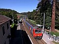 Lépin-le-Lac-La Bauche station


See also
References
- ^ "Répertoire national des élus: les maires" (in French). data.gouv.fr, Plateforme ouverte des données publiques françaises. 13 September 2022.
- ^ "Populations légales 2021". The National Institute of Statistics and Economic Studies. 28 December 2023.
Wikimedia Commons has media related to Lépin-le-Lac.
- v
- t
- e

- Aiguebelette-le-Lac
- Aillon-le-Jeune
- Aillon-le-Vieux
- Aime-la-Plagne
- Aiton
- Aix-les-Bains
- Albertvillesubpr
- Albiez-le-Jeune
- Albiez-Montrond
- Allondaz
- Les Allues
- Apremont
- Arbin
- Argentine
- Arith
- Arvillard
- Attignat-Oncin
- Aussois
- Les Avanchers-Valmorel
- Avressieux
- Avrieux
- Ayn
- La Balme
- Barberaz
- Barby
- Bassens
- La Bâthie
- La Bauche
- Beaufort
- Bellecombe-en-Bauges
- Les Belleville
- Belmont-Tramonet
- Bessans
- Betton-Bettonet
- Billième
- La Biolle
- Bonneval-sur-Arc
- Bonvillard
- Bonvillaret
- Bourdeau
- Le Bourget-du-Lac
- Bourget-en-Huile
- Bourgneuf
- Bourg-Saint-Maurice
- Bozel
- Brides-les-Bains
- La Bridoire
- Brison-Saint-Innocent
- Césarches
- Cevins
- Challes-les-Eaux
- Chambérypref
- La Chambre
- Chamousset
- Chamoux-sur-Gelon
- Champagneux
- Champagny-en-Vanoise
- Champ-Laurent
- Chanaz
- La Chapelle
- La Chapelle-Blanche
- La Chapelle-du-Mont-du-Chat
- Les Chapelles
- La Chapelle-Saint-Martin
- Châteauneuf
- Le Châtelard
- La Chavanne
- Les Chavannes-en-Maurienne
- Chignin
- Chindrieux
- Cléry
- Cognin
- Cohennoz
- Coise-Saint-Jean-Pied-Gauthier
- La Compôte
- Conjux
- Corbel
- Courchevel
- Crest-Voland
- La Croix-de-la-Rochette
- Cruet
- Curienne
- Les Déserts
- Détrier
- Domessin
- Doucy-en-Bauges
- Drumettaz-Clarafond
- Dullin
- Les Échelles
- École
- Entrelacs
- Entremont-le-Vieux
- Épierre
- Esserts-Blay
- Feissons-sur-Salins
- Flumet
- Fontcouverte-la-Toussuire
- Fourneaux
- Freney
- Fréterive
- Frontenex
- Gerbaix
- La Giettaz
- Gilly-sur-Isère
- Grand-Aigueblanche
- Grésy-sur-Aix
- Grésy-sur-Isère
- Grignon
- Hautecour
- Hauteluce
- Hauteville
- Jacob-Bellecombette
- Jarrier
- Jarsy
- Jongieux
- Laissaud
- Landry
- La Léchère
- Lépin-le-Lac
- Lescheraines
- Loisieux
- Lucey
- Marcieux
- Marthod
- Mercury
- Méry
- Meyrieux-Trouet
- Modane
- Les Mollettes
- Montagnole
- Montagny
- Montailleur
- Montcel
- Montendry
- Montgilbert
- Monthion
- Montmélian
- Montricher-Albanne
- Montsapey
- Montvalezan
- Montvernier
- La Motte-en-Bauges
- La Motte-Servolex
- Motz
- Moûtiers
- Mouxy
- Myans
- Nances
- Notre-Dame-de-Bellecombe
- Notre-Dame-des-Millières
- Notre-Dame-du-Cruet
- Notre-Dame-du-Pré
- Novalaise
- Le Noyer
- Ontex
- Orelle
- Pallud
- Peisey-Nancroix
- La Plagne Tarentaise
- Planaise
- Planay
- Plancherine
- Le Pont-de-Beauvoisin
- Le Pontet
- Porte-de-Savoie
- Pralognan-la-Vanoise
- Presle
- Pugny-Chatenod
- Puygros
- Queige
- La Ravoire
- Rochefort
- Rognaix
- Rotherens
- Ruffieux
- Saint-Alban-de-Montbel
- Saint-Alban-d'Hurtières
- Saint-Alban-des-Villards
- Saint-Alban-Leysse
- Saint-André
- Saint-Avre
- Saint-Baldoph
- Saint-Béron
- Saint-Cassin
- Saint-Christophe
- Saint-Colomban-des-Villards
- Sainte-Foy-Tarentaise
- Sainte-Hélène-du-Lac
- Sainte-Hélène-sur-Isère
- Sainte-Marie-d'Alvey
- Sainte-Marie-de-Cuines
- Sainte-Reine
- Saint-Étienne-de-Cuines
- Saint-Franc
- Saint-François-de-Sales
- Saint-François-Longchamp
- Saint-Genix-les-Villages
- Saint-Georges-d'Hurtières
- Saint-Jean-d'Arves
- Saint-Jean-d'Arvey
- Saint-Jean-de-Chevelu
- Saint-Jean-de-Couz
- Saint-Jean-de-la-Porte
- Saint-Jean-de-Mauriennesubpr
- Saint-Jeoire-Prieuré
- Saint-Julien-Mont-Denis
- Saint-Léger
- Saint-Marcel
- Saint-Martin-d'Arc
- Saint-Martin-de-la-Porte
- Saint-Martin-sur-la-Chambre
- Saint-Michel-de-Maurienne
- Saint-Nicolas-la-Chapelle
- Saint-Offenge
- Saint-Ours
- Saint-Pancrace
- Saint-Paul-sur-Yenne
- Saint-Paul-sur-Isère
- Saint-Pierre-d'Albigny
- Saint-Pierre-d'Alvey
- Saint-Pierre-de-Belleville
- Saint-Pierre-de-Curtille
- Saint-Pierre-de-Genebroz
- Saint-Pierre-d'Entremont
- Saint-Pierre-de-Soucy
- Saint-Rémy-de-Maurienne
- Saint-Sorlin-d'Arves
- Saint-Sulpice
- Saint-Thibaud-de-Couz
- Saint-Vital
- Salins-Fontaine
- Séez
- Serrières-en-Chautagne
- Sonnaz
- La Table
- Thénésol
- Thoiry
- La Thuile
- Tignes
- La Tour-en-Maurienne
- Tournon
- Tours-en-Savoie
- Traize
- Tresserve
- Trévignin
- La Trinité
- Ugine
- Val-Cenis
- Val-d'Arc
- Val-d'Isère
- Valgelon-La Rochette
- Valloire
- Valmeinier
- Venthon
- Verel-de-Montbel
- Verel-Pragondran
- Le Verneil
- Verrens-Arvey
- Verthemex
- Villard-d'Héry
- Villard-Léger
- Villard-Sallet
- Villard-sur-Doron
- Villarembert
- Villargondran
- Villarodin-Bourget
- Villaroger
- Villaroux
- Vimines
- Vions
- Viviers-du-Lac
- Voglans
- Yenne
- pref: prefecture
- subpr: subprefecture
Authority control databases | |
|---|---|
| International |
|
| National |
|


