Lac de Mauvoisin
Reservoir in Valais, Switzerland
45°59′53″N 7°20′58″E / 45.99806°N 7.34944°E / 45.99806; 7.34944
Lac de Mauvoisin is a reservoir in the canton of Valais, Switzerland. The reservoir is formed by the Mauvoisin Dam, which is 250 metres (820 ft) high. The dam is the 11th highest in the world, and the 6th highest arch dam. It was built in 1951–1957, and raised by 13.5 metres (44 ft) in 1991.
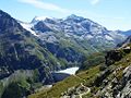
The reservoir lies in the upper Val de Bagnes, between the massif of the Grand Combin, one of the highest mountains of the Alps, and La Ruinette. The highest peak visible from the lake is the Combin de la Tsessette (4,135 metres (13,566 ft)).
Gallery
-
 Mauvoisin Dam, with Mont Blanc de Cheilon in the background
 -
 Dranse de Bagnes, a stream flowing from the Mauvoisin lake


See also
External links
- Swiss Dams: Profile of Mauvoisin
 Media related to Lac de Mauvoisin at Wikimedia Commons
Authority control databases | |
|---|---|
| International |
|
| National |
|
- v
- t
- e


