List of crossings of the River Tay
List of crossings of the River Tay
| Category | Heritage Status Criteria[1] |
|---|---|
| A | Buildings of national or international importance, either architectural or historic, or fine little-altered examples of some particular period, style or building type. |
| B | Buildings of regional or more than local importance, or major examples of some particular period, style or building type which may have been altered. |
| C | Buildings of local importance, lesser examples of any period, style, or building type, as originally constructed or moderately altered; and simple traditional buildings which group well with others in categories A and B. |
Map all coordinates using OpenStreetMap
Download coordinates as:
- KML
- GPX (all coordinates)
- GPX (primary coordinates)
- GPX (secondary coordinates)
| Crossing | Date | Coordinates | Heritage status | Locality | Notes | Photo
|
|---|---|---|---|---|---|---|
| Kenmore Bridge[2] | 1774 | 56°35′09″N 4°00′06″W / 56.5858°N 4.0018°W / 56.5858; -4.0018 (Kenmore Bridge) | A | Kenmore | 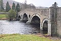 | |
| Chinese Bridge, Taymouth Castle[3] | Early 19th cent | 56°35′48″N 3°59′05″W / 56.5967°N 3.9846°W / 56.5967; -3.9846 (Chinese Bridge) | A | Kenmore |  | |
| Newhall Bridge, Taymouth Castle[4] | 1842 | 56°35′55″N 3°58′25″W / 56.5985°N 3.9736°W / 56.5985; -3.9736 (Newhall Bridge) | B | Kenmore | ||
| Wade's Bridge | 1733 | 56°37′17″N 3°52′25″W / 56.6214°N 3.8737°W / 56.6214; -3.8737 (Wade's Bridge) | A | Aberfeldy |  | |
| Aberfeldy Footbridge | 56°37′31″N 3°52′14″W / 56.6254°N 3.8705°W / 56.6254; -3.8705 (Aberfeldy Footbridge) | - | Aberfeldy |  | ||
| Grandtully Bridge | 56°39′31″N 3°46′34″W / 56.6585°N 3.776°W / 56.6585; -3.776 (Grandtully Bridge) | - | Grandtully |  | ||
| Pitnacree Bridge | 56°39′32″N 3°45′17″W / 56.6589°N 3.7547°W / 56.6589; -3.7547 (A827 Bridge) | - | Grandtully | A827 |  | |
| Logierait Viaduct[5] | 1865 | 56°38′48″N 3°41′01″W / 56.6468°N 3.6835°W / 56.6468; -3.6835 (Logierait Viaduct) | A | Ballinluig | Aberfeldy Branch Line, now private road | 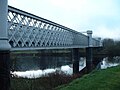 |
| Dalguise Viaduct[6] | 1863 | 56°36′45″N 3°38′20″W / 56.6126°N 3.639°W / 56.6126; -3.639 (Dalguise Viaduct) | A | Dunkeld | Highland Main Line | 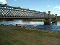 |
| Jubilee Bridge | 56°34′33″N 3°37′18″W / 56.5758°N 3.6218°W / 56.5758; -3.6218 (Jubilee Bridge) | - | Dunkeld | A9 | 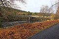 | |
| Dunkeld Bridge | 1809 | 56°33′50″N 3°35′07″W / 56.5639°N 3.5853°W / 56.5639; -3.5853 (Dunkeld Bridge) | A | Dunkeld |  | |
| Caputh Bridge | 56°32′19″N 3°28′58″W / 56.5387°N 3.4828°W / 56.5387; -3.4828 (Caputh Bridge) | - | Caputh | 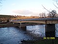 | ||
| Kinclaven Bridge[7] | 1905 | 56°31′36″N 3°22′06″W / 56.5267°N 3.3682°W / 56.5267; -3.3682 (Kinclaven Bridge) | B | Meikleour |  | |
| Cargill Viaduct | 56°31′08″N 3°23′02″W / 56.5188°N 3.3839°W / 56.5188; -3.3839 (Cargill Viaduct) | - | Cargill | Scottish Midland Junction Railway | 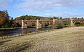 | |
| Destiny Bridge | Under Construction 2024 | 56°25′57″N 3°28′08″W / 56.4325°N 3.469°W / 56.4325; -3.469 (Destiny Bridge) | - | Perth | ||
| Perth Bridge | 1771 | 56°23′56″N 3°25′32″W / 56.399°N 3.4255°W / 56.399; -3.4255 (Perth Bridge) | A | Perth |  | |
| Queen's Bridge, Perth | 1960 | 56°23′42″N 3°25′29″W / 56.3949°N 3.4246°W / 56.3949; -3.4246 (Queen's Bridge) | - | Perth |  | |
| Perth Railway Bridge | 56°23′32″N 3°25′30″W / 56.3922°N 3.4249°W / 56.3922; -3.4249 (Railway Bridge) | - | Perth | 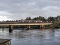 | ||
| Friarton Bridge | 1978 | 56°22′45″N 3°24′33″W / 56.3791°N 3.4092°W / 56.3791; -3.4092 (Friarton Bridge) | - | Perth | M90 |  |
| Tay Rail Bridge | 1887 | 56°26′12″N 2°59′15″W / 56.4367°N 2.9874°W / 56.4367; -2.9874 (Tay Rail Bridge) | A | Dundee |  | |
| Tay Road Bridge | 1966 | 56°27′13″N 2°56′57″W / 56.4535°N 2.9493°W / 56.4535; -2.9493 (Tay Road Bridge) | - | Dundee | 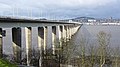 |
References
- ^ A Review of existing information for Scotland's Historic Environment Audit (SHEA), Historic Scotland, 20 December 2016, p. 79, ISBN 9781904966609
- ^ British Listed Buildings
- ^ British Listed Buildings
- ^ British Listed Buildings
- ^ British Listed Buildings
- ^ British Listed Buildings
- ^ British Listed Buildings


