List of volcanoes in Colombia
Map all coordinates using OpenStreetMap
Download coordinates as:
- KML
- GPX (all coordinates)
- GPX (primary coordinates)
- GPX (secondary coordinates)
class=notpageimage|
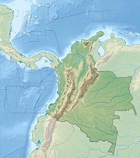
Major volcanoes in ColombiaThis is a list of active and extinct volcanoes in Colombia.
| Name | Elevation | Coordinates | Last eruption | |
|---|---|---|---|---|
| meters | feet | |||
| Azufral | 4070 | 13,353 | 1°05′N 77°41′W / 1.08°N 77.68°W / 1.08; -77.68 | 930 BC ? |
| Cerro Bravo | 4000 | 13,123 | 5°05′31″N 75°18′00″W / 5.092°N 75.30°W / 5.092; -75.30 | 1720 ± 150 years |
| Cerro Machín | 2749 | 9,019 | 4°29′N 75°24′W / 4.48°N 75.40°W / 4.48; -75.40 | 1180 |
| Cerro Negro de Mayasquer | 4445 | 14,583 | 0°59′N 77°53′W / 0.98°N 77.88°W / 0.98; -77.88 | 1936 |
| Chiles | 4756 | 15,616 | 0°47′52″N 77°57′3″W / 0.79778°N 77.95083°W / 0.79778; -77.95083 | 1936 |
| Cumbal | 4764 | 15,630 | 0°49′N 77°58′W / 0.82°N 77.96°W / 0.82; -77.96 | 1926 |
| Doña Juana | 4137 | 13,573 | 1°28′N 76°55′W / 1.47°N 76.92°W / 1.47; -76.92 | 1906 |
| Galeras | 4276 | 14,029 | 1°13′0″N 77°22′0″W / 1.21667°N 77.36667°W / 1.21667; -77.36667 | 2014 |
| Nevado del Huila | 5365 | 17,601 | 2°55′N 76°03′W / 2.92°N 76.05°W / 2.92; -76.05 | 2012 |
| Nevado del Tolima | 5276 | 17,310 | 4°40′N 75°20′W / 4.67°N 75.33°W / 4.67; -75.33 | 1943 |
| Nevado del Ruiz | 5321 | 17,457 | 4°53′N 75°22′W / 4.883°N 75.367°W / 4.883; -75.367 | 2012 |
| Petacas | 4054 | 13,300 | 1°34′N 76°47′W / 1.57°N 76.78°W / 1.57; -76.78 | 5950 BC ± 500 years |
| Puracé | 4646 | 15,243 | 2°19′N 76°24′W / 2.32°N 76.40°W / 2.32; -76.40 | 1977 |
| Romeral | 3858 | 12,657 | 5°12′22″N 75°21′50″W / 5.206°N 75.364°W / 5.206; -75.364 | 5950 BC ± 500 years |
| Santa Isabel | 4950 | 16,240 | 4°49′N 75°22′W / 4.82°N 75.37°W / 4.82; -75.37 | 2800 BC ± 100 years |
| Sotará | 4580 | 15,030 | 2°07′N 76°35′W / 2.12°N 76.58°W / 2.12; -76.58 | Unknown |
See also
 Colombia portal
 Volcanoes portal
 Geology portal


- List of earthquakes in Colombia
- List of fossiliferous stratigraphic units in Colombia
- Geology of Colombia
References
- Siebert L, Simkin T (2002–present). Volcanoes of the World: an Illustrated Catalog of Holocene Volcanoes and their Eruptions. Smithsonian Institution, Global Volcanism Program Digital Information Series, GVP-3 (http://www.volcano.si.edu).
- v
- t
- e
(6° N – 3° S)
- Paipa-Iza
- Romeral
- Cerro Bravo
- Nevado del Ruiz
- Nevado del Tolima
- Nevado del Huila
- Puracé
- Doña Juana
- Galeras
- Azufral
- Chiles
- Cayambe
- Reventador
- Pichincha
- Antisana
- Aliso
- Soche
- Illiniza
- Cotopaxi
- Quilotoa
- Chimborazo
- Tungurahua
- Licto volcanic field
- Sangay
(14°–27° S)
- Quimsachata
- Auquihuato
- Firura
- Sara Sara
- Solimana
- Coropuna
- Hualca Hualca
- Sabancaya
- Huambo volcanic field
- Ampato
- Andagua volcanic field
- Chachani
- Misti
- Ubinas
- Pichu Pichu
- Huaynaputina
- Ticsani
- Tutupaca
- Yucamane
- Purupuruni
- Casiri
- Tacora
- Taapaca
- Parinacota
- Lauca
- Guallatiri
- Tata Sabaya
- Isluga
- Irruputuncu
- Olca-Paruma
- Aucanquilcha
- Azufre
- Zapaleri
- Sairecabur
- Licancabur
- Purico complex
- Pacana
- Aguas Calientes
- Lascar
- Chiliques
- Aracar
- Socompa
- Llullaillaco
- Lastarria
- Lazufre
- Cordón del Azufre
- Galán
- Peinado
- San Francisco
- Cueros de Purulla
- Incahuasi
- Ojos del Salado
(33°–46° S)
- Tupungato
- Tupungatito
- Maipo
- Calabozos
- Descabezado Grande
- Cerro Azul
- Nevado de Longaví
- Nevados de Chillán
- Antuco
- Copahue
- Callaqui
- Lonquimay
- Llaima
- Sollipulli
- Villarrica
- Quetrupillán
- Lanín
- Mocho-Choshuenco
- Carrán-Los Venados
- Puyehue-Cordón Caulle
- Casablanca
- Osorno
- Calbuco
- Hornopirén
- Huequi
- Michinmahuida
- Chaitén
- Corcovado
- Mentolat
- Cay
- Macá
- Mate Grande
- Hudson
(49°–55° S)
Note: volcanoes are ordered by latitude from north to south
Volcanoes of Colombia | ||
|---|---|---|
| Western Ranges |     | |
| Central Ranges |
| |
| Eastern Ranges | ||
| Other | ||
| Source |
| |
 Category • Images Category • Images  | ||


