Mansface Hill
41°30′51.92″N 109°28′46.60″W / 41.5144222°N 109.4796111°W / 41.5144222; -109.4796111Geography Location Green River, Wyoming, U.S. Climbing Easiest route Access Road Absaroka Range Bighorn Mountains Black Hills
Gallatin Range Gros Ventre Range Laramie Mountains Medicine Bow Mountains Salt River Range Teton Range Uinta Mountains Wind River Range Wyoming Range Others
Mansface Hill is a mountain located in Green River, Wyoming. The mountain is named for its rock outcroppings, which form the shape of a face looking up into the sky.
Access
Mansface is accessible from Green River via two access roads. The first road begins at the top of an area known as South Hill on Wyoming Highway 530. This route follows a pipeline for about half a mile and then begins turning north to the summit of the hill. The second begins near the west end of River View Drive in Green River. Google Earth and most GPS maps identify the road to the summit on the west side as "Knotty Pine Street." During the winter, the road is often drifted over, and some times impassable.
Summit
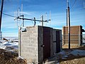
On the summit of the hill are various radio towers for both local business and government entities. A tower for the city of Green River 's police department is the newest tower, constructed some time in the summer of 2004. A local cellular telephone tower is located at the center of the hill, and is primarily what can be seen from surrounding areas. It was constructed in late 2001 and early 2002.[1] The hill also has a tower for local KCSP affiliate radio station K232CU, which serves Green River on 94.3 FM.[2][3]
Christmas tree
Every year in either late November or early December, several local residents haul a Christmas tree to the summit. The tree is decorated and is lit at night. Power to the tree comes from the tower farm located nearby. In 2007, the tree was placed by members of the local business "The Radio Network", which owns radio stations KFRZ, KYCS, KUGR, and KZWB.[4]
-
 The east face with the Christmas tree, 2008
 -
 K232CU's tower, located at the heart of the tower farm
 -
 A close up of the Christmas tree, with deer below
 -
 Green River, looking east from Mansface


References
See also
- v
- t
- e
- Abiathar Peak
- Atkins Peak
- Barronette Peak
- Breccia Peak
- Clayton Mountain
- Colter Peak
- Druid Peak
- Eagle Peak
- Fortress Mountain
- Francs Peak
- Index Peak
- Mount Chittenden
- First Peoples Mountain
- Mount Hornaday
- Mount Langford
- Mount Norris
- Mount Schurz
- Mount Stevenson
- Pilot Peak
- Sheep Mesa
- The Thunderer
- Washakie Needles
- Younts Peak
| Bear Lodge Mountains | |
|---|---|
| Others |
- Antler Peak
- Bannock Peak
- Bunsen Peak
- Clagett Butte
- Dome Mountain (Park County)
- Echo Peak
- Gray Peak
- Joseph Peak
- Mount Everts
- Mount Haynes
- Mount Holmes
- Mount Jackson
- Purple Mountain
- Quadrant Mountain
- Sepulcher Mountain
- Terrace Mountain
- Three Rivers Peak
- Trilobite Point
- White Peaks
- Darwin Peak
- Doubletop Peak
- Sheep Mountain
- Elk Mountain (Carbon County)
- Medicine Bow Peak
- Albright Peak
- Battleship Mountain
- Bivouac Peak
- Buck Mountain
- Cathedral Group
- Cleaver Peak
- Cloudveil Dome
- Disappointment Peak
- Doane Peak
- Dry Ridge Mountain
- Eagles Rest Peak
- Elk Mountain (Teton County)
- Forellen Peak
- Fossil Mountain
- Grand Teton
- Green Lakes Mountain
- Housetop Mountain
- The Jaw
- Littles Peak
- Maidenform Peak
- Middle Teton
- Moose Mountain
- Mount Bannon
- Mount Glory
- Mount Hunt
- Mount Jedediah Smith
- Mount Meek
- Mount Moran
- Mount Owen
- Mount Saint John
- Mount Wister
- Mount Woodring
- Mount Woodrow Wilson
- Nez Perce Peak
- Owl Peak
- Prospectors Mountain
- Rammell Mountain
- Ranger Peak
- Raynolds Peak
- Red Mountain
- Rendezvous Mountain
- Rendezvous Peak
- Rock of Ages
- Rockchuck Peak
- Rolling Thunder Mountain
- Shadow Peak
- South Teton
- Spearhead Peak
- Static Peak
- Survey Peak
- Symmetry Spire
- Table Mountain
- Teepe Pillar
- Teewinot Mountain
- Temple Peak
- Thor Peak
- Traverse Peak
- Veiled Peak
- The Wall
- Window Peak
- American Legion Peak
- Atlantic Peak
- Bair Peak
- Bastion Peak
- Bastion Peak-Northeast Peak
- Bears Ears Mountain
- Big Sandy Mountain
- Block Tower
- Bow Mountain
- Brown Cliffs North
- Cathedral Peak
- Desolation Peak
- Dog Tooth Peak
- Dome Mountain (Hot Springs County)
- Doublet Peak
- Downs Mountain
- East Temple Peak
- Flagstone Peak (Fremont County)
- Fremont Peak
- Gannett Peak
- Harrower Peak
- Henderson Peak
- Jackson Peak
- Klondike Peak
- Knife Point Mountain
- Lander Peak
- Lizard Head Peak
- Mitchell Peak
- Mount Bonneville
- Mount Chauvenet
- Mount Febbas
- Mount Helen
- Mount Hooker
- Mount Koven
- Mount Lander
- Mount Nystrom
- Mount Owen
- Mount Sacagawea
- Mount Warren
- Mount Washakie
- Mount Whitecap
- Overhanging Tower
- Payson Peak
- Pingora Peak
- Pylon Peak
- Raid Peak
- Rampart Peak
- Roaring Fork Mountain
- Roberts Mountain
- Shale Mountain
- Sharks Nose
- South Downs Mountain
- The Sphinx
- Split Mountain
- Sunbeam Peak
- Three Waters Mountain
- Torrey Peak
- Turret Peak
- Twin Peaks
- Union Peak
- Valentine Mountain
- Valentine Peak
- War Bonnet Peak
- Warrior Peaks
- Watch Tower
- Whiskey Mountain
- Wind River Peak
- Wolfs Head
- Amethyst Mountain
- Aspen Mountain
- Barlow Peak
- Bridger Mountains
- Cook Peak
- Copper Mountain
- Dirty Mountain
- Douglas Knob
- Dunraven Peak
- Factory Hill
- Ferris Mountains
- Folsom Peak
- Garfield Peak
- Granite Mountains
- Granite Peak
- Heart Mountain
- Hedges Peak
- Hoyt Peak
- Jelm Mountain
- Mansface Hill
- Mount Hancock
- Mount Leidy
- Mount Sheridan
- Mount Washburn
- National Park Mountain
- Owl Creek Mountains
- Prospect Peak (Park County)
- Rawhide Buttes
- Roaring Mountain
- Sierra Madre Range
- Signal Mountain
- Snake River Range
- Specimen Ridge
- Sublette Mountain
- Tongue Butte
- Trischman Knob
- White Mountain
- Wilkins Peak
 | This article about a location in Wyoming is a stub. You can help Wikipedia by expanding it. |
- v
- t
- e


