Mbomou River
River
4°07′44″N 22°26′10″E / 4.129°N 22.436°E / 4.129; 22.436The Mbomou River or Bomu (also spelled M'bomou in French) forms part of the boundary between the Central African Republic (CAR) and the Democratic Republic of the Congo (DRC).[1][2]
The Mbomou merges with the Uele River to form the Ubangi River.[3] The Ubangi, a tributary of the Congo, also serves as part of the border between the CAR and the DRC.
Gallery
-
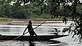 Man on the Mbomou river, between Bangassou and Ndu

References
- ^ "Bomu River". Britannica. Retrieved 2022-09-25.
- ^ Shelley, Fred M. (2013-04-23). Nation Shapes: The Story Behind the World's Borders. ABC-CLIO. p. 273. ISBN 978-1-61069-106-2.
- ^ Org, Glob Ener Interconn Deve &Coop (2020-04-06). Research on Hydropower Development and Delivery in Congo River. Springer Nature. p. 26. ISBN 978-981-15-3428-7.
Further reading
- Tshimanga, Raphael M.; N'kaya, Guy D. Moukandi; Alsdorf, Douglas (2022-02-08). Congo Basin Hydrology, Climate, and Biogeochemistry: A Foundation for the Future. John Wiley & Sons. ISBN 978-1-119-65699-9.
- Hughes, R. H. (1992). A Directory of African Wetlands. IUCN. ISBN 978-2-88032-949-5.
External links
 Media related to Mbomou river at Wikimedia Commons
| ||
|---|---|---|
| Congo left bank (south) |  | |
| Kasai basin | ||
| Congo right bank (north) | ||
| Lualaba and tributaries | ||
| Other | ||
| Authority control databases |
|
|---|
This article related to a river in the Central African Republic is a stub. You can help Wikipedia by expanding it. |
- v
- t
- e
This article related to a river in the Democratic Republic of the Congo is a stub. You can help Wikipedia by expanding it. |
- v
- t
- e


