Mount Shishaldin
A symmetrical volcano in Alaska


Mount Shishaldin
Unimak Island, Alaska, U.S.
U.S. National Natural Landmark
Shishaldin Volcano, or Mount Shishaldin (/ʃɪˈʃældən/), is a moderately active volcano on Unimak Island in the Aleutian Islands chain of Alaska in the United States.[1] It is the highest mountain peak of the Aleutian Islands and rises about 10,000m (33,000 ft) from the bottom of the Aleutian Trench 140 miles south of the volcano. The volcano's topographic contour lines are nearly perfect circles above 6,500 feet (1,981 m). The lower north and south slopes are somewhat steeper than the lower eastern and western slopes. Only on the volcano's west flank between about 3500 to 6500 ft are small areas of rough topography which are remnants of an older collapsed volcano upon which Shishaldin is built. The volcano is the westernmost of three large stratovolcanoes along an east–west line in the eastern half of Unimak Island.
The upper 6,600 ft (2,012 m) is almost entirely covered by glacial snow and ice. In all, Shishaldin's glacial shield covers about 35 square miles (91 km2). It is flanked to the northwest by 24 monogenetic parasitic cones, an area blanketed by massive lava flows. The Shishaldin cone is less than 10,000 years old and is constructed on a glacially eroded remnant of an ancestral somma and shield. Remnants of the older ancestral volcano are exposed on the west and northeast sides at 4,900 to 5,900 ft (1,494 to 1,798 m) elevation. The Shishaldin edifice contains about 300 cubic kilometers (72 cubic miles) of material. A very steady steam plume rises from its small summit crater which is about 500 ft (152 m) across and slightly breached along the north rim. In appearance, the volcano can vary from nearly completely white to almost all black, depending on the occurrence of ashfall deposits.
In 1967, Shishaldin Volcano was designated as a National Natural Landmark - the Shishaldin Volcano National Natural Landmark - by the National Park Service. The landmark is 62,714 acres and a plaque was erected near the coast.[2]
Name
The Aleuts named the volcano Sisquk[3] or Sisagux,[4] meaning "mountain which points the way when I am lost." The spelling Shishaldin comes from the Russian version, Шишалдина, of the Aleut name.[4]
Activity
This volcano has had many recorded eruptions during the 19th and 20th centuries, and a couple of reports of volcanic activity in the area during the 18th century may have referred to Shishaldin as well. Therefore, the volcano's entire recorded history is spotted with reports of activity. AVO has 24 confirmed eruptions at Shishaldin, making it the volcano with the third most confirmed eruptions (after Akutan and Pavlof). However, Shishaldin has the most eruptions (this means confirmed and possible eruptions) in Alaska, but half of the eruptions are unconfirmed. Recent, well-documented eruptions were in 1995–96 and 1999. Since the 1999 eruption, it has maintained seismic activity, typically having very low-magnitude volcanic earthquakes (most are below magnitude 1) every 1–2 minutes. During this period of non-eruptive seismic activity, it has been puffing steam, with puffs also occurring about every 1–2 minutes. There were reports in 2004 of small quantities of ash being emitted with the steam. In 2014, a low-level effusive eruption cycle started which lasted into 2016.
A new period of activity started in July 2019 with incandescence observed in the summit crater during a time of increased seismic activity. On July 23, an active lava lake and minor spattering within the summit crater was observed. A new lava effusion event began on October 13 advancing over the next several weeks. The summit cone partially collapsed on November 25, producing a pyroclastic flow down the northwest side of the volcano and a new lava flow. On December 12, a short-lived explosion from Shishaldin expelled an ash cloud to 20,000–25,000 feet (6,100–7,600 m). During late December, eruptive activity continued with lava flows and low-level explosive activity at the summit. On January 3, 2020, seismicity led to an ash cloud eruption that reached as high as 27,000 feet (8,200 m). Another large ash cloud was emitted on January 19, 2020. This event ended shortly afterwards with an abrupt end in seismicity. The lava flows emitted during the eruptive events have cut deep channels in the snow and ice mantle of the volcano's north slope.
After more than two years of dormancy, another eruptive cycle began and on 14 July 2023, the volcano emitted ash plumes up to 40,000 feet high after several explosions at the summit. Fourteen significant explosive events occurred at Shishaldin between 12 July and 3 November 2023. After the November 3 explosive event, much smaller explosions, steam and gas emissions and collapse events around the summit crater rim occurred frequently for about a week, By January 2024, only minor steam emissions and small events deep in the summit crater continued.
The Alaska Volcano Observatory monitors the volcano for more hazardous activity with seismometers and satellite images. Due to the remote location of the volcano, visual observations are rare.
Climbing
The first recorded ascent of Shishaldin was in 1932, by G. Peterson and two companions. Given the straightforward nature of the climbing (Alaska Grade 1, snow up to 40 degree slope), it is possible that an earlier ascent occurred, either by native Aleuts, Russians, or other visitors. Shishaldin is rather unique in that its appearance changes very little to a climber during an ascent. A group climbing Shishaldin in May, 2005 set a base camp at 2500 feet on the east side after a four day hike and ski trip from the village of False Pass. As they climbed the cone, they noted "we could never believe it was so tall since the summit always looked 'so close'. Yet it never seemed to get any closer!" It took that group about 8 hours to climb to the top. Shishaldin is a popular ski descent (6,000 ft (1,829 m) vertical) for local climbers (of whom there are few). Due to its remoteness, Shishaldin is not often climbed by outsiders.
Gallery
-
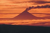 An image of the volcano at sunset from 2005
 -
 A view of the volcano's 1999 eruption.
 -
 Map showing volcanoes of Alaska Peninsula.
 -
 An overhead view of the volcano from November 24, 2013
 -
 Shishaldin and Isanotski Volcanoes.
 -
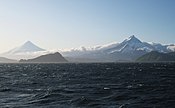 Shishaldin (left) and Isanotski volcanoes on Unimak Island.
 -
 Shishaldin Volcano on the west end of Unimak Island.


See also
 North America portal
 United States portal
 Alaska portal
 Mountains portal
 Volcanoes portal


- List of mountain peaks of North America
- List of Ultras of the United States
- List of volcanoes in the United States
Further reading
- Finch, Ruy Herbert, 1934, "Shishaldin Volcano: Proceedings of the Fifth Pacific Science Conference, Canada", Proceedings - Pacific Science Conference v. 3, pp. 2369–2376
- Fournelle, John Harold, 1988, The geology and petrology of Shishaldin Volcano, Unimak Island, Aleutian Arc, Alaska, Ph.D. thesis Johns Hopkins University
References
- ^ Alaska Volcano Observatory, Volcano Information -- Shishaldin, Retrieved Dec. 16, 2022.
- ^ "National Natural Landmarks - National Natural Landmarks (U.S. National Park Service)". www.nps.gov. Retrieved 2019-03-20.
- ^ Wood, Charles A.; Kienle, Jurgen, eds. (1992). "Shishaldin, Eastern Aleutian Islands". Volcanoes of North America: United States and Canada. Cambridge, England: Cambridge University Press. p. 48. ISBN 978-0-521-36469-0.
- ^ a b Bright, William (2004). Native American Placenames of the United States. Norman, Oklahoma: University of Oklahoma Press. p. 439. ISBN 978-0-8061-3598-4.
External links
Mount Shishaldin at Wikipedia's sister projects
 Definitions from Wiktionary
 Media from Commons
 News from Wikinews
 Quotations from Wikiquote
 Texts from Wikisource
 Textbooks from Wikibooks
 Resources from Wikiversity
- "Shishaldin". Global Volcanism Program. Smithsonian Institution.
- Petersen, Tanja; Caplan-Auerbach, Jacqueline; McNutt, Stephen R (2006), "Sustained long-period seismicity at Shishaldin Volcano, Alaska", Journal of Volcanology and Geothermal Research, 151 (4): 365, Bibcode:2006JVGR..151..365P, doi:10.1016/j.jvolgeores.2005.09.003
- Volcanoes of the Alaska Peninsula and Aleutian Islands-Selected Photographs
- Alaska Volcano Observatory (Shishaldin webcam)
- Michael Wood and Colby Coombs, Alaska: a climbing guide, The Mountaineers, 2001.
- v
- t
- e
- Denali
- Mauna Kea
- Mount Rainier
- Mount Fairweather
- Mount Blackburn
- Mount Hayes
- Mount Saint Elias
- Mount Marcus Baker
- Mount Whitney
- Haleakalā
- Mount Shasta
- Shishaldin Volcano
- Redoubt Volcano
- Mount Elbert
- Mount Baker
- Mount Torbert
- San Jacinto Peak
- San Gorgonio Mountain
- Charleston Peak
- Pavlof Volcano
- Mount Veniaminof
- Mount Adams
- Mount Hubbard
- Mount Isto
- Iliamna Volcano
- Mount Olympus
- Mount Cook
- Mount Hood
- Mount Sanford
- Mount Tom White
- Wheeler Peak
- Glacier Peak
- Mount Kimball
- Mount Griggs
- Mount Foraker
- White Mountain Peak
- Mount Crillon
- Mauna Loa
- Cloud Peak
- Gannett Peak
- Mount Vsevidof
- Mount Hesperus
- Mount Bona
- Mount Drum
- Mount Chiginagak
- Grand Teton
- Sacajawea Peak
- Mount Neacola
- Kings Peak
- Mount Graham
- Mount Douglas
- Mount San Antonio
- Kichatna Spire
- De Long Peak
- Telescope Peak
- Mount Peale
- Pogromni Volcano
- Dewey Peak
- Mount Washington
- Mount Igikpak
- Snow Tower
- Mount Mitchell
- Truuli Peak
- Humphreys Peak
- Borah Peak
- Mount Natazhat
- Hanagita Peak
- Tanaga Volcano
- Makushin Volcano
- Sovereign Mountain
- Mount Jefferson (Nevada)
- Mount Ellen
- Isanotski Peaks
- Deseret Peak
- Mount Jefferson (Oregon)
- Isthmus Peak
- Frosty Peak
- Pilot Peak
- Crazy Peak
- Great Sitkin Volcano
- Puʻu Kukui
- Mount Cleveland (Alaska)
- McDonald Peak
- Mount Wrangell
- South Sister
- Devils Paw
- Mount Seattle
- Sierra Blanca Peak
- Pikes Peak
- Mount Russell
- Mount Nebo
- Snowshoe Peak
- North Schell Peak
- Hayford Peak
- Mount Foresta
- Star Peak
- Veniaminof Peak
- Flat Top Mountain
- Bearhole Peak
- Mount Steller
- Mount Stuart
- Blanca Peak
- Mount Miller
- Carlisle Volcano
- Mount Timpanogos
- Bashful Peak
- Ibapah Peak
- Mount Cleveland (Montana)
- Kawaikini
- Tetlin Peak
- Arc Dome
- Lassen Peak
- Mount Deborah
- Necons Peak
- Abercrombie Mountain
- Mount Lemmon
- Mount Gareloi
- Chiricahua Peak
- Stony Peak
- Mount Eddy
- Mount Augusta
- Copper Peak
- Mount Bear
- Korovin Volcano
- Miller Peak
- Kamakou

Authority control databases | |
|---|---|
| International |
|
| National |
|
| Geographic |
|


