Nara, Mali
Commune and town in Koulikoro Region, Mali
15°10′5″N 7°17′15″W / 15.16806°N 7.28750°W / 15.16806; -7.28750 Mali
Mali (2009 census)[1]
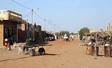
Nara (Bambara: ߣߊߙߊ tr. Nara) is a town and rural commune in the Koulikoro Region of southwestern Mali. The town is the administrative center of the Nara Cercle. It is about 37 kilometres (23 mi), south of the international border with Mauritania and approximately 374 kilometres (232 mi), by road, northeast of the Malian capital, Bamako.[3]
The rural commune covers an area of 1,300 square kilometres (500 sq mi) and includes the town and 16 surrounding villages.[4] In the 2009 census the commune had a population of 19,793.[1]
References
- ^ a b Resultats Provisoires RGPH 2009 (Région de Koulikoro) (PDF) (in French), République de Mali: Institut National de la Statistique.
- ^ Common and Fundamental Operational Datasets Registry: Mali, United Nations Office for the Coordination of Humanitarian Affairs, archived from the original on 2012-12-14, retrieved 2012-08-23. commune_mali.zip (Originally from the Direction Nationale des Collectivités Territoriales, République du Mali)
- ^ Google (11 December 2020). "Distance Between Bamako, Mali and Nara, Mali" (Map). Google Maps. Google. Retrieved 11 December 2020.
- ^ Communes de la Région de Koulikoro (PDF) (in French), Ministère de l’administration territoriale et des collectivités locales, République du Mali, archived from the original (PDF) on 2012-03-09.
External links
- Plan de Sécurité Alimentaire Commune Rurale de Nara 2007-2011 (PDF) (in French), Commissariat à la Sécurité Alimentaire, République du Mali, USAID-Mali, 2007, archived from the original (PDF) on 2012-09-17.
- v
- t
- e
Communes and towns of Koulikoro RegionCapital: Koulikoro
- Banamba (Banamba)
- Ben Kadi (Samakele)
- Boron (Boron)
- Duguwolowula (Touba)
- Kiban (Kiban)
- Madina Sacko (Madina Sacko)
- Sebete (Sebete)
- Toubakoro (Toubakoro)

- Banko (Banko)
- Benkadi (Kotoula)
- Binko (Tingole)
- Degnekoro (Degnekoro)
- Diebé (Diebé)
- Diédougou (Belekosoba)
- Diouman (Dioumanzana)
- Dolendougou (Dandougou)
- Guegneka (Fana)
- Jekafo (Jekafo)
- Kaladougou (Diolila)
- Kemekafo (Senou)
- Kerela (Kerela)
- Kilidougou (N'Tobougou)
- Massigui (Massigui)
- Nangola (Nangola)
- Niantjila (Niantjila)
- N'Dolondougou (Mena)
- N'Garadougou (N'Gara)
- N'Golobougou (N'Golobougou)
- Tenindougou (Falako)
- Wacoro (Wacoro)
- Zan Coulibaly (Marka Coungo)
- Kati (Kati)
- Baguinéda-Camp (Baguinéda-Camp)
- Bankoumana (Bankoumana)
- Bossofala (Neguela)
- Bougoula (Bougoula)
- Daban (Daban)
- Diago (Diago)
- Dialakoroba (Dialakoroba)
- Dialakorodji (Dialakorodji)
- Diédougou (Torado)
- Dio-Gare (Dio-Gare)
- Dogodouman (Dogodouman)
- Dombila (Dombila)
- Doubabougou (Doubabougou)
- Faraba (Faraba)
- Kalabancoro (Kalabancoro)
- Kalifabougou (Kalifabougou)
- Kambila (Kambila)
- Kourouba (Kourouba)
- Mandé (Ouezzindougou)
- Moribabougou (Moribabougou)
- Mountougoula (Mountougoula)
- N'Gabacoro (N'Gabacoro-Droit)
- N'Gouraba (N'Gouraba)
- Niagadina (Niagadina)
- Nioumamakana (Nioumamakana)
- N'Tjiba (Faladié)
- Ouélessébougou (Ouélessébougou)
- Safo (Safo)
- Sanankoro Djitoumou (Sanankoro Djitoumou)
- Sanankoroba (Sanankoroba)
- Sangarébougou (Sangarébougou)
- Siby
- Sobra (Sandama)
- Tiakadougou-Dialakoro (Tiakadougou-Dialakoro)
- Tiélé (Tiélé)
- Yélékébougou (Yélékébougou)
| Authority control databases |
|
|---|
 | This Koulikoro Region location article is a stub. You can help Wikipedia by expanding it. |
- v
- t
- e


