National Register of Historic Places listings in Emanuel County, Georgia
This is a list of properties and districts in Emanuel County, Georgia that are listed on the National Register of Historic Places (NRHP).
Map all coordinates using OpenStreetMap
Download coordinates as:
- KML
- GPX (all coordinates)
- GPX (primary coordinates)
- GPX (secondary coordinates)
This National Park Service list is complete through NPS recent listings posted June 14, 2024.[1]
`
- v
- t
- e
Properties on the National Register of Historic Places in Georgia by county
- Appling
- Atkinson
- Bacon
- Baker
- Baldwin
- Banks
- Barrow
- Bartow
- Ben Hill
- Berrien
- Bibb
- Bleckley
- Brantley
- Brooks
- Bryan
- Bulloch
- Burke
- Butts
- Calhoun
- Camden
- Candler
- Carroll
- Catoosa
- Charlton
- Chatham
- Chattahoochee
- Chattooga
- Cherokee
- Clarke
- Clay
- Clayton
- Clinch
- Cobb
- Coffee
- Colquitt
- Columbia
- Cook
- Coweta
- Crawford
- Crisp
- Dade
- Dawson
- Decatur
- DeKalb
- Dodge
- Dooly
- Dougherty
- Douglas
- Early
- Echols
- Effingham
- Elbert
- Emanuel
- Evans
- Fannin
- Fayette
- Floyd
- Forsyth
- Franklin
- Fulton
- Gilmer
- Glascock
- Glynn
- Gordon
- Grady
- Greene
- Gwinnett
- Habersham
- Hall
- Hancock
- Haralson
- Harris
- Hart
- Heard
- Henry
- Houston
- Irwin
- Jackson
- Jasper
- Jeff Davis
- Jefferson
- Jenkins
- Johnson
- Jones
- Lamar
- Lanier
- Laurens
- Lee
- Liberty
- Lincoln
- Long
- Lowndes
- Lumpkin
- Macon
- Madison
- Marion
- McDuffie
- McIntosh
- Meriwether
- Miller
- Mitchell
- Monroe
- Montgomery
- Morgan
- Murray
- Muscogee
- Newton
- Oconee
- Oglethorpe
- Paulding
- Peach
- Pickens
- Pierce
- Pike
- Polk
- Pulaski
- Putnam
- Quitman
- Rabun
- Randolph
- Richmond
- Rockdale
- Schley
- Screven
- Seminole
- Spalding
- Stephens
- Stewart
- Sumter
- Talbot
- Taliaferro
- Tattnall
- Taylor
- Telfair
- Terrell
- Thomas
- Tift
- Toombs
- Towns
- Treutlen
- Troup
- Turner
- Twiggs
- Union
- Upson
- Walker
- Walton
- Ware
- Warren
- Washington
- Wayne
- Webster
- Wheeler
- White
- Whitfield
- Wilcox
- Wilkes
- Wilkinson
- Worth

Current listings
| [2] | Name on the Register | Image | Date listed[3] | Location | City or town | Description |
|---|---|---|---|---|---|---|
| 1 | James Coleman House |  | April 28, 1992 (#92000384) | 323 N. Main St. 32°36′07″N 82°20′11″W / 32.60186°N 82.33651°W / 32.60186; -82.33651 (James Coleman House) | Swainsboro | Built in 1904; now a Bed and Breakfast |
| 2 | Josiah Davis House | 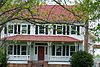 | October 5, 1982 (#82000145) | South of Canoochee on GA 192 32°37′55″N 82°09′59″W / 32.63208°N 82.16633°W / 32.63208; -82.16633 (Josiah Davis House) | Canoochee | |
| 3 | Davis-Proctor House |  | December 20, 2010 (#10001049) | 133 First Ave. 32°34′59″N 82°09′00″W / 32.58307°N 82.15013°W / 32.58307; -82.15013 (Davis-Proctor House) | Twin City | Built in 1890, is a contributing property to the Twin City Historic District |
| 4 | Albert Neal Durden House |  | April 20, 1990 (#90000561) | Co. Rd. 360 32°34′19″N 82°13′26″W / 32.57200°N 82.22389°W / 32.57200; -82.22389 (Albert Neal Durden House) | Twin City | |
| 5 | Emanuel County Courthouse and Sheriff Department | 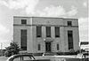 | June 14, 1995 (#95000715) | Main St. 32°35′49″N 82°20′05″W / 32.59685°N 82.3347°W / 32.59685; -82.3347 (Emanuel County Courthouse and Sheriff Department) | Swainsboro | Demolished |
| 6 | First Methodist Episcopal Church |  | February 12, 1999 (#99000160) | Junction of Third Ave. and Third St. 32°26′29″N 82°12′50″W / 32.44127°N 82.21375°W / 32.44127; -82.21375 (First Methodist Episcopal Church) | Stillmore | |
| 7 | John Rountree Log House | 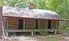 | August 15, 1997 (#97000841) | Junction of U.S. Route 80 and GA 192 32°35′02″N 82°09′55″W / 32.58399°N 82.16531°W / 32.58399; -82.16531 (John Rountree Log House) | Twin City | A Place in Peril as of 2017. Local website |
| 8 | Swainsboro Light and Water Plant |  | October 27, 2004 (#04001184) | Bounded by East Moring and South Coleman Sts. and the Norfolk Southern Railway 32°35′48″N 82°19′52″W / 32.59665°N 82.33111°W / 32.59665; -82.33111 (Swainsboro Light and Water Plant) | Swainsboro | Built in 1921 |
| 9 | Twin City Historic District |  | February 8, 2014 (#13001168) | 6th, Railroad & 5th Aves., Maple & College Sts. 32°35′01″N 82°09′02″W / 32.583486°N 82.150577°W / 32.583486; -82.150577 (Twin City Historic District) | Twin City |
References
- ^ National Park Service, United States Department of the Interior, "National Register of Historic Places: Weekly List Actions", retrieved June 14, 2024.
- ^ Numbers represent an alphabetical ordering by significant words. Various colorings, defined here, differentiate National Historic Landmarks and historic districts from other NRHP buildings, structures, sites or objects.
- ^ The eight-digit number below each date is the number assigned to each location in the National Register Information System database, which can be viewed by clicking the number.
Wikimedia Commons has media related to National Register of Historic Places in Emanuel County, Georgia.
| |
|---|---|
| Topics | |
| Lists by state |
|
| Lists by insular areas | |
| Lists by associated state | |
| Other areas | |
| Related | |
| |


