National Register of Historic Places listings in Latah County, Idaho

This is a list of the National Register of Historic Places listings in Latah County, Idaho.
This is intended to be a complete list of the properties and districts on the National Register of Historic Places in Latah County, Idaho, United States. Latitude and longitude coordinates are provided for many National Register properties and districts; these locations may be seen together in a map.[1]
There are 56 properties and districts listed on the National Register in the county.[2]
This National Park Service list is complete through NPS recent listings posted June 14, 2024.[3]
Map all coordinates using OpenStreetMap
Download coordinates as:
- KML
- GPX (all coordinates)
- GPX (primary coordinates)
- GPX (secondary coordinates)
Current listings
| [4] | Name on the Register[5] | Image | Date listed[6] | Location | City or town | Description |
|---|---|---|---|---|---|---|
| 1 | Abram A. Adams House |  | April 24, 2017 (#100000908) | 191 State St. 46°34′36″N 116°42′35″W / 46.576803°N 116.709732°W / 46.576803; -116.709732 (Abram A. Adams House) | Juliaetta | |
| 2 | Administration Building, University of Idaho |  | February 14, 1978 (#78001072) | University of Idaho campus 46°43′32″N 117°00′40″W / 46.725643°N 117.011004°W / 46.725643; -117.011004 (Administration Building, University of Idaho) | Moscow | Original building burned in 1906 Constructed 1907–09 (main) |
| 3 | American Legion Cabin | 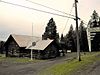 | September 11, 1986 (#86002197) | Alternate U.S. Route 95 46°55′16″N 116°53′25″W / 46.921165°N 116.890270°W / 46.921165; -116.890270 (American Legion Cabin) | Potlatch | |
| 4 | Bank of Juliaetta |  | January 15, 1998 (#97001649) | 301 Main St. 46°34′41″N 116°42′25″W / 46.577928°N 116.706991°W / 46.577928; -116.706991 (Bank of Juliaetta) | Juliaetta | |
| 5 | Bethany Memorial Chapel |  | December 6, 1979 (#79000798) | Kendrick-Deary Highway 46°39′51″N 116°37′25″W / 46.664191°N 116.623729°W / 46.664191; -116.623729 (Bethany Memorial Chapel) | Kendrick | |
| 6 | Boarding House |  | September 11, 1986 (#86002199) | 850 Pine St. 46°55′28″N 116°54′03″W / 46.924315°N 116.900810°W / 46.924315; -116.900810 (Boarding House) | Potlatch | |
| 7 | Axel Bohman House |  | August 10, 2011 (#11000523) | 116 N. Main St. 46°44′19″N 116°46′17″W / 46.738739°N 116.771326°W / 46.738739; -116.771326 (Axel Bohman House) | Troy | |
| 8 | Ole Bohman House |  | May 22, 2013 (#13000293) | 114 N. Main St. 46°44′19″N 116°46′16″W / 46.738557°N 116.771121°W / 46.738557; -116.771121 (Ole Bohman House) | Troy | |
| 9 | Bovill Opera House | 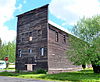 | January 27, 2010 (#09001280) | 412 2nd Ave. 46°51′34″N 116°23′42″W / 46.859486°N 116.394933°W / 46.859486; -116.394933 (Bovill Opera House) | Bovill | |
| 10 | Harry and Fern Campbell House |  | December 3, 2018 (#100003175) | 101 E 4th St. 46°44′09″N 116°46′06″W / 46.7359°N 116.7682°W / 46.7359; -116.7682 (Harry and Fern Campbell House) | Troy | |
| 11 | Commercial Historic District |  | September 11, 1986 (#86002201) | Roughly Pine St. between 7th and 5th Sts. 46°55′17″N 116°54′04″W / 46.921340°N 116.901103°W / 46.921340; -116.901103 (Commercial Historic District) | Potlatch | |
| 12 | Cordelia Lutheran Church | 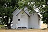 | August 31, 1995 (#95001058) | Danielson Rd., south of the junction with Genesee-Troy Rd. 46°39′37″N 116°53′50″W / 46.660177°N 116.897166°W / 46.660177; -116.897166 (Cordelia Lutheran Church) | Moscow | |
| 13 | Mason Cornwall House |  | December 2, 1977 (#77000465) | 308 S. Hayes St. 46°43′56″N 116°59′17″W / 46.732176°N 116.988079°W / 46.732176; -116.988079 (Mason Cornwall House) | Moscow | |
| 14 | Cox Barn |  | February 1, 2010 (#09001281) | 1290 American Ridge Rd. 46°36′23″N 116°42′52″W / 46.606269°N 116.714356°W / 46.606269; -116.714356 (Cox Barn) | Kendrick | |
| 15 | Davids' Building |  | December 11, 1979 (#79000799) | 3rd and Main Sts. 46°43′56″N 117°00′04″W / 46.732153°N 117.001052°W / 46.732153; -117.001052 (Davids' Building) | Moscow | |
| 16 | Deary Garage |  | January 25, 2024 (#100009873) | 307 Main Street 46°47′59″N 116°33′40″W / 46.7996°N 116.5611°W / 46.7996; -116.5611 (Deary Garage) | Deary | |
| 17 | Deesten Farmstead |  | April 2, 2008 (#08000250) | 3611 U.S. Route 95, S. 46°40′09″N 117°01′41″W / 46.669143°N 117.028011°W / 46.669143; -117.028011 (Deesten Farmstead) | Moscow | |
| 18 | First Methodist Church |  | October 5, 1978 (#78001073) | 322 E. 3rd St. 46°43′57″N 116°59′51″W / 46.732603°N 116.997591°W / 46.732603; -116.997591 (First Methodist Church) | Moscow | |
| 19 | Fort Russell Neighborhood Historic District |  | November 26, 1980 (#80001329) | Roughly bounded by Jefferson, D, Hayes, and 3rd Sts. 46°44′06″N 116°59′43″W / 46.734886°N 116.995384°W / 46.734886; -116.995384 (Fort Russell Neighborhood Historic District) | Moscow | |
| 20 | Four-Room House |  | September 11, 1986 (#86002204) | 1015 Pine St. 46°55′33″N 116°54′01″W / 46.925879°N 116.900214°W / 46.925879; -116.900214 (Four-Room House) | Potlatch | |
| 21 | Freeze Community Church |  | May 3, 1990 (#90000679) | W. Freeze Rd., 1 mile (1.6 km) west of U.S. Route 95 46°57′46″N 116°56′59″W / 46.962890°N 116.949720°W / 46.962890; -116.949720 (Freeze Community Church) | Potlatch | |
| 22 | Genesee Exchange Bank |  | January 8, 1979 (#79000796) | Walnut and Fir Sts. 46°33′03″N 116°55′32″W / 46.550695°N 116.925562°W / 46.550695; -116.925562 (Genesee Exchange Bank) | Genesee | |
| 23 | Hotel Bovill |  | June 23, 1994 (#94000629) | 602 Park St. (State Highway 3) 46°51′39″N 116°23′47″W / 46.860950°N 116.396387°W / 46.860950; -116.396387 (Hotel Bovill) | Bovill | |
| 24 | Hotel Moscow | 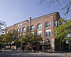 | November 30, 1978 (#78001074) | 4th and Main Sts. 46°43′55″N 117°00′07″W / 46.731904°N 117.001842°W / 46.731904; -117.001842 (Hotel Moscow) | Moscow | North of Friendship Square |
| 25 | Hotel Rietmann | 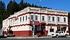 | November 29, 2001 (#01001302) | 525–529 S. Main St. 46°44′03″N 116°46′01″W / 46.734167°N 116.766937°W / 46.734167; -116.766937 (Hotel Rietmann) | Troy | |
| 26 | Kappa Sigma Fraternity, Gamma Theta Chapter |  | September 3, 1996 (#96000945) | 918 Blake Ave. 46°43′35″N 117°00′29″W / 46.726357°N 117.008035°W / 46.726357; -117.008035 (Kappa Sigma Fraternity, Gamma Theta Chapter) | Moscow | |
| 27 | Kendrick Downtown Historic District |  | January 2, 2018 (#100001920) | Generally bounded by 3rd, & S Kirby Sts., original NPRR alignment & grade rising N of E Main St. 46°36′49″N 116°39′01″W / 46.613670°N 116.650330°W / 46.613670; -116.650330 (Kendrick Downtown Historic District) | Kendrick | |
| 28 | Kendrick Fraternal Temple |  | March 27, 2013 (#13000108) | 614 E. Main St. 46°36′51″N 116°39′00″W / 46.614121°N 116.649975°W / 46.614121; -116.649975 (Kendrick Fraternal Temple) | Kendrick | |
| 29 | Kenworthy Theatre |  | November 29, 2001 (#01001305) | 508 S. Main St. 46°43′51″N 117°00′04″W / 46.730750°N 117.001073°W / 46.730750; -117.001073 (Kenworthy Theatre) | Moscow | |
| 30 | Thomas Kirby House |  | April 1, 1999 (#99000414) | 102 N. 9th St. 46°36′51″N 116°38′49″W / 46.614164°N 116.646829°W / 46.614164; -116.646829 (Thomas Kirby House) | Kendrick | |
| 31 | Russell Lawrence Farmstead | 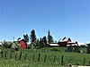 | December 1, 2011 (#11000862) | 5471 ID 8 46°47′58″N 116°29′30″W / 46.799430°N 116.491692°W / 46.799430; -116.491692 (Russell Lawrence Farmstead) | Deary | part of the Agricultural Properties of Latah County, Idaho MPS |
| 32 | Almon Asbury Lieuallen House | 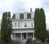 | January 3, 1978 (#78001075) | 101 S. Almon St. 46°44′01″N 117°00′16″W / 46.733595°N 117.004471°W / 46.733595; -117.004471 (Almon Asbury Lieuallen House) | Moscow | |
| 33 | W. J. McConnell House |  | November 21, 1974 (#74000743) | 110 S. Adams St. 46°44′00″N 116°59′48″W / 46.733256°N 116.996803°W / 46.733256; -116.996803 (W. J. McConnell House) | Moscow | |
| 34 | McConnell–McGuire Building | 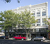 | February 7, 1978 (#78001076) | Main and 1st Sts. 46°44′01″N 117°00′04″W / 46.733475°N 117.001072°W / 46.733475; -117.001072 (McConnell–McGuire Building) | Moscow | |
| 35 | Memorial Gymnasium |  | October 5, 1977 (#77000466) | University of Idaho campus 46°43′35″N 117°00′50″W / 46.726510°N 117.013857°W / 46.726510; -117.013857 (Memorial Gymnasium) | Moscow | Opened 96 years ago in 1928 |
| 36 | Moscow Carnegie Library |  | June 18, 1979 (#79000800) | 110 S. Jefferson St. 46°44′00″N 116°59′54″W / 46.733279°N 116.998311°W / 46.733279; -116.998311 (Moscow Carnegie Library) | Moscow | |
| 37 | Moscow Downtown Historic District |  | July 22, 2005 (#05000710) | Generally bounded by 1st St., 6th St., Washington St., and the alley between Main and Jackson 46°43′55″N 117°00′05″W / 46.731947°N 117.001411°W / 46.731947; -117.001411 (Moscow Downtown Historic District) | Moscow | |
| 38 | Moscow High School | 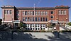 | May 5, 1992 (#92000416) | 410 E. 3rd St. 46°43′58″N 116°59′47″W / 46.732759°N 116.996468°W / 46.732759; -116.996468 (Moscow High School) | Moscow | 1912 Center; high school until 1939, then junior high until 1959 |
| 39 | Moscow Post Office and Courthouse |  | July 3, 1973 (#73000686) | Washington and 3rd Sts. 46°43′58″N 116°59′59″W / 46.732670°N 116.999722°W / 46.732670; -116.999722 (Moscow Post Office and Courthouse) | Moscow | Moscow City Hall |
| 40 | Mountain Home Grange Hall |  | September 29, 2021 (#100007014) | 1044 Mountain Home Rd. 47°00′28″N 116°56′26″W / 47.0077°N 116.9406°W / 47.0077; -116.9406 (Mountain Home Grange Hall) | Potlatch vicinity | |
| 41 | Nob Hill Historic District |  | September 11, 1986 (#86002206) | Roughly bounded by 4th, Spruce, 3rd, and Cedar Sts. 46°55′10″N 116°53′52″W / 46.919323°N 116.897803°W / 46.919323; -116.897803 (Nob Hill Historic District) | Potlatch | |
| 42 | Nordby Farmstead |  | May 15, 2009 (#09000293) | 1301 Old U.S. Route 95 46°33′52″N 116°54′34″W / 46.564435°N 116.909505°W / 46.564435; -116.909505 (Nordby Farmstead) | Genesee | |
| 43 | Nu Art Theatre | 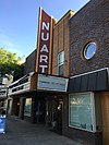 | November 29, 2001 (#01001304) | 516 S. Main St. 46°43′50″N 117°00′04″W / 46.730558°N 117.001013°W / 46.730558; -117.001013 (Nu Art Theatre) | Moscow | |
| 44 | Ridenbaugh Hall |  | September 14, 1977 (#77000467) | University of Idaho campus 46°43′28″N 117°00′32″W / 46.724485°N 117.009026°W / 46.724485; -117.009026 (Ridenbaugh Hall) | Moscow | |
| 45 | St. Joseph's Catholic Church |  | November 17, 1982 (#82000351) | 301 1st Avenue 46°51′30″N 116°23′46″W / 46.858390°N 116.396208°W / 46.858390; -116.396208 (St. Joseph's Catholic Church) | Bovill | |
| 46 | Sigma Alpha Epsilon Fraternity House | 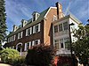 | December 2, 1993 (#93001335) | 920 Deakin St. 46°43′34″N 117°00′23″W / 46.726192°N 117.006441°W / 46.726192; -117.006441 (Sigma Alpha Epsilon Fraternity House) | Moscow | |
| 47 | Skattaboe Block | 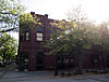 | May 22, 1978 (#78001077) | Main and 4th Sts. 46°43′54″N 117°00′07″W / 46.731537°N 117.001819°W / 46.731537; -117.001819 (Skattaboe Block) | Moscow | South of Friendship Square |
| 48 | Arthur Snow House |  | May 5, 2009 (#09000294) | 2949 Clyde Rd. 46°41′36″N 117°00′39″W / 46.693346°N 117.010894°W / 46.693346; -117.010894 (Arthur Snow House) | Moscow | |
| 49 | Edward and Ida Soncarty Barn | 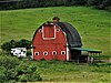 | April 2, 2008 (#08000251) | 1671 Deep Creek Rd. 47°01′44″N 116°53′13″W / 47.028824°N 116.886904°W / 47.028824; -116.886904 (Edward and Ida Soncarty Barn) | Potlatch | |
| 50 | Joseph A. Terteling House |  | September 11, 1986 (#86002208) | 1015 Fir St. 46°55′33″N 116°54′05″W / 46.925881°N 116.901371°W / 46.925881; -116.901371 (Joseph A. Terteling House) | Potlatch | |
| 51 | Three-Room House |  | September 11, 1986 (#86002210) | 940 Cedar St. 46°55′30″N 116°53′54″W / 46.925015°N 116.898286°W / 46.925015; -116.898286 (Three-Room House) | Potlatch | |
| 52 | Troy Downtown Historic District |  | March 11, 2010 (#10000073) | 339 S. Main St. through 527 S. Main St. 46°44′05″N 116°46′04″W / 46.734794°N 116.767866°W / 46.734794; -116.767866 (Troy Downtown Historic District) | Troy | |
| 53 | Troy Hospital | 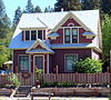 | August 10, 2011 (#11000524) | 604 S. Main St. 46°44′03″N 116°45′58″W / 46.734165°N 116.766082°W / 46.734165; -116.766082 (Troy Hospital) | Troy | |
| 54 | University of Idaho Gymnasium and Armory |  | January 3, 1983 (#83000287) | University of Idaho campus 46°43′35″N 117°00′44″W / 46.726432°N 117.012314°W / 46.726432; -117.012314 (University of Idaho Gymnasium and Armory) | Moscow | Art & Architecture South |
| 55 | Vollmer Building |  | January 8, 1979 (#79000797) | Walnut St. 46°33′03″N 116°55′30″W / 46.550728°N 116.924884°W / 46.550728; -116.924884 (Vollmer Building) | Genesee | |
| 56 | White Spring Ranch | 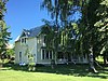 | January 6, 2004 (#03001368) | 1004 Lorang Rd. Hwy. 95 & Borgen Rd. 46°34′39″N 116°56′58″W / 46.577593°N 116.949519°W / 46.577593; -116.949519 (White Spring Ranch) | Genesee | |
| 57 | Workers' Neighborhood Historic District |  | September 11, 1986 (#86002211) | Roughly Spruce St. between 8th and 5th 46°55′20″N 116°53′47″W / 46.922135°N 116.896477°W / 46.922135; -116.896477 (Workers' Neighborhood Historic District) | Potlatch |
See also
Wikimedia Commons has media related to National Register of Historic Places in Latah County, Idaho.
References
- ^ The latitude and longitude information provided in this table was derived originally from the National Register Information System, which has been found to be fairly accurate for about 99% of listings. Some locations in this table may have been corrected to current GPS standards.
- ^ "National Register of Historic Places: Weekly List Actions". National Park Service. Retrieved March 29, 2009.
- ^ National Park Service, United States Department of the Interior, "National Register of Historic Places: Weekly List Actions", retrieved June 14, 2024.
- ^ Numbers represent an alphabetical ordering by significant words. Various colorings, defined here, differentiate National Historic Landmarks and historic districts from other NRHP buildings, structures, sites or objects.
- ^ "National Register Information System". National Register of Historic Places. National Park Service. April 24, 2008.
- ^ The eight-digit number below each date is the number assigned to each location in the National Register Information System database, which can be viewed by clicking the number.
- v
- t
- e
- Ada
- Adams
- Bannock
- Bear Lake
- Benewah
- Bingham
- Blaine
- Boise
- Bonner
- Bonneville
- Boundary
- Butte
- Camas
- Canyon
- Caribou
- Cassia
- Clark
- Clearwater
- Custer
- Elmore
- Franklin
- Fremont
- Gem
- Gooding
- Idaho
- Jefferson
- Jerome
- Kootenai
- Latah
- Lemhi
- Lewis
- Lincoln
- Madison
- Minidoka
- Nez Perce
- Oneida
- Owyhee
- Payette
- Power
- Shoshone
- Teton
- Twin Falls
- Valley
- Washington

| |
|---|---|
| Topics | |
| Lists by state |
|
| Lists by insular areas | |
| Lists by associated state | |
| Other areas | |
| Related | |
| |


