National Register of Historic Places listings in Sevier County, Arkansas
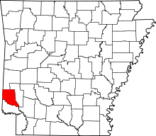
This is a list of the National Register of Historic Places listings in Sevier County, Arkansas.
This is intended to be a complete list of the properties on the National Register of Historic Places in Sevier County, Arkansas, United States. The locations of National Register properties for which the latitude and longitude coordinates are included below, may be seen in a map.[1]
There are 17 properties listed on the National Register in the county. Two sites that were once listed have been removed.
This National Park Service list is complete through NPS recent listings posted June 21, 2024.[2]
Map all coordinates using OpenStreetMap
Download coordinates as:
- KML
- GPX (all coordinates)
- GPX (primary coordinates)
- GPX (secondary coordinates)
Current listings
| [3] | Name on the Register[4] | Image | Date listed[5] | Location | City or town | Description |
|---|---|---|---|---|---|---|
| 1 | Bishop Brookes House | 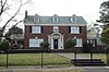 | November 18, 1999 (#99001352) | 407 N. 6th St. 34°02′23″N 94°20′39″W / 34.039722°N 94.344167°W / 34.039722; -94.344167 (Bishop Brookes House) | De Queen | |
| 2 | DeQueen & Eastern Railroad Machine Shop | 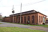 | June 20, 1996 (#96000643) | Northwestern edge of the De Queen and Eastern railroad yard, adjacent to Highway 329 34°02′08″N 94°19′59″W / 34.035556°N 94.333056°W / 34.035556; -94.333056 (DeQueen & Eastern Railroad Machine Shop) | De Queen | part of the Railroad Era Resources of Southwest Arkansas Multiple Property Submission (MPS) |
| 3 | De Queen & Eastern Railroad Overpass | Upload image | May 19, 2023 (#100008976) | US 71 over the De Queen & Eastern RR Line 33°58′12″N 94°10′06″W / 33.9699°N 94.1684°W / 33.9699; -94.1684 (De Queen & Eastern Railroad Overpass) | Lockesburg | |
| 4 | DeQueen Commercial Historic District |  | January 26, 2012 (#11001051) | Roughly bounded by W. DeQueen Ave., N. 2nd St., W. Stilwell Ave. & N. 4th Ave. 34°02′14″N 94°20′25″W / 34.037286°N 94.340278°W / 34.037286; -94.340278 (DeQueen Commercial Historic District) | De Queen | |
| 5 | First Presbyterian Church |  | December 1, 1994 (#94001419) | Southwestern corner of the junction of Vandervoort and N. 5th Sts. 34°02′24″N 94°20′34″W / 34.04°N 94.342778°W / 34.04; -94.342778 (First Presbyterian Church) | De Queen | |
| 6 | First United Methodist Church | 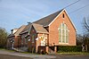 | May 19, 1994 (#94000468) | East of the junction of 2nd St. and 5th Ave. 33°58′05″N 94°09′55″W / 33.968056°N 94.165278°W / 33.968056; -94.165278 (First United Methodist Church) | Lockesburg | |
| 7 | Gillham City Jail |  | January 27, 2012 (#11001052) | Approximately 325 feet (99 m) southeast of Hornberg Ave. & Front St. 34°10′07″N 94°18′51″W / 34.168575°N 94.31425°W / 34.168575; -94.31425 (Gillham City Jail) | Gillham | |
| 8 | Goff and Gamble Merchandise Store | 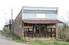 | June 20, 1996 (#96000646) | 1 block north of the Kansas City Southern railroad tracks in the center of Gillham 34°10′08″N 94°18′54″W / 34.168889°N 94.315°W / 34.168889; -94.315 (Goff and Gamble Merchandise Store) | Gillham | part of the Railroad Era Resources of Southwest Arkansas MPS |
| 9 | Hale Creek Bridge |  | May 26, 2004 (#04000489) | County Road 271 34°04′47″N 94°11′09″W / 34.079722°N 94.185833°W / 34.079722; -94.185833 (Hale Creek Bridge) | Red Wing | part of the Historic Bridges of Arkansas MPS |
| 10 | Hayes Hardware Store |  | December 3, 1980 (#80000787) | 314 DeQueen St. 34°02′16″N 94°20′27″W / 34.037778°N 94.340833°W / 34.037778; -94.340833 (Hayes Hardware Store) | De Queen | |
| 11 | King Schoolhouse |  | June 20, 1996 (#96000645) | Approximately 1 mile (1.6 km) east of U.S. Highway 71 near central King 34°08′51″N 94°17′58″W / 34.1475°N 94.299444°W / 34.1475; -94.299444 (King Schoolhouse) | King | part of the Railroad Era Resources of Southwest Arkansas MPS |
| 12 | Little Cossatot River Bridge |  | April 6, 1990 (#90000538) | County Road 139H over the Little Cossatot River 33°58′29″N 94°12′18″W / 33.974722°N 94.205°W / 33.974722; -94.205 (Little Cossatot River Bridge) | Lockesburg | part of the Historic Bridges of Arkansas MPS |
| 13 | Lockesburg High School Gymnasium | Upload image | May 18, 2018 (#100002458) | 128 E Main St. 33°58′02″N 94°10′04″W / 33.9673°N 94.1678°W / 33.9673; -94.1678 (Lockesburg High School Gymnasium) | Lockesburg | |
| 14 | Lockesburg Waterworks | 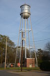 | September 20, 2007 (#07000964) | Junction of Hickory and Azalea Sts. 33°58′07″N 94°10′01″W / 33.968611°N 94.166944°W / 33.968611; -94.166944 (Lockesburg Waterworks) | Lockesburg | part of the New Deal Recovery Efforts in Arkansas MPS |
| 15 | Oak Grove Rosenwald School |  | May 26, 2004 (#04000494) | Oak Grove Rd. 33°53′11″N 94°08′00″W / 33.886389°N 94.133333°W / 33.886389; -94.133333 (Oak Grove Rosenwald School) | Oak Grove | |
| 16 | Old US 71-Little River Approach |  | May 26, 2004 (#04000493) | Ashely Camp Rd. from the northern bank of the Little River to south of the old U.S. Highway 71 and Highway 27 33°47′41″N 94°08′39″W / 33.794722°N 94.144167°W / 33.794722; -94.144167 (Old US 71-Little River Approach) | Ben Lomond | part of the Arkansas Highway History and Architecture MPS |
| 17 | Otis Theodore and Effiegene Locke Wingo House |  | June 1, 2004 (#04000501) | 510 W. De Queen Ave. 34°02′22″N 94°20′39″W / 34.039444°N 94.344167°W / 34.039444; -94.344167 (Otis Theodore and Effiegene Locke Wingo House) | De Queen |
Former listings
| [3] | Name on the Register | Image | Date listed | Date removed | Location | City or town | Description |
|---|---|---|---|---|---|---|---|
| 1 | Hotel Dee Swift | Upload image | June 20, 1996 (#96000644) | January 25, 2010 | 123 N. Port Arthur St. 34°02′15″N 94°20′13″W / 34.0375°N 94.3369°W / 34.0375; -94.3369 (Hotel Dee Swift) | De Queen | |
| 2 | Locke-Nall House | Upload image | May 1, 1989 (#89000340) | September 25, 2012 | Off U.S. Highways 59/71 north of Lockesburg 33°58′30″N 94°10′33″W / 33.975°N 94.175833°W / 33.975; -94.175833 (Locke-Nall House) | Lockesburg |
See also
Wikimedia Commons has media related to National Register of Historic Places in Sevier County, Arkansas.
- List of National Historic Landmarks in Arkansas
- National Register of Historic Places listings in Arkansas
References
- ^ The latitude and longitude information provided in this table was derived originally from the National Register Information System, which has been found to be fairly accurate for about 99% of listings. Some locations in this table may have been corrected to current GPS standards.
- ^ National Park Service, United States Department of the Interior, "National Register of Historic Places: Weekly List Actions", retrieved June 21, 2024.
- ^ a b Numbers represent an alphabetical ordering by significant words. Various colorings, defined here, differentiate National Historic Landmarks and historic districts from other NRHP buildings, structures, sites or objects.
- ^ "National Register Information System". National Register of Historic Places. National Park Service. March 13, 2009.
- ^ The eight-digit number below each date is the number assigned to each location in the National Register Information System database, which can be viewed by clicking the number.
- v
- t
- e
- List of U.S. National Historic Landmarks by state:
- Alabama
- Alaska
- Arizona
- Arkansas
- California
- Colorado
- Connecticut
- Delaware
- Florida
- Georgia
- Hawaii
- Idaho
- Illinois
- Indiana
- Iowa
- Kansas
- Kentucky
- Louisiana
- Maine
- Maryland
- Massachusetts
- Michigan
- Minnesota
- Mississippi
- Missouri
- Montana
- Nebraska
- Nevada
- New Hampshire
- New Jersey
- New Mexico
- New York
- North Carolina
- North Dakota
- Ohio
- Oklahoma
- Oregon
- Pennsylvania
- Rhode Island
- South Carolina
- South Dakota
- Tennessee
- Texas
- Utah
- Vermont
- Virginia
- Washington
- West Virginia
- Wisconsin
- Wyoming
 National Register of Historic Places portal
 Category


