Ovelgönne
Municipality in Lower Saxony, Germany
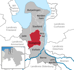
Location of Ovelgönne within Wesermarsch district
(2022-12-31)[2]
26939
Ovelgönne is a municipality in the district of Wesermarsch, in Lower Saxony, Germany. It is situated approximately 27 km northeast of Oldenburg, and 40 km northwest of Bremen. The municipality of Ovelgönne has its administration in the village of Oldenbrok and not in the homonymous village of Ovelgönne.
History
Ovelgönne has its origins in the "Oevelgünne" fortress which was constructed by Count Johann V of Oldenburg (1482–1526) at the end of June 1514 in order to enforce his rule over the surrounding area.
In 1583, Ovelgönne was given additional fortifications. From 1628 to 1631, Imperial Troops were quartered at Ovelgönne during the Thirty Years' War.
References
- ^ "Direktwahlen in Niedersachsen vom 12. September 2021" (PDF). Landesamt für Statistik Niedersachsen. 13 October 2021.
- ^ "LSN-Online Regionaldatenbank, Tabelle A100001G: Fortschreibung des Bevölkerungsstandes, Stand 31. Dezember 2022" (in German). Landesamt für Statistik Niedersachsen.
- v
- t
- e
Towns and municipalities in Wesermarsch (district)

Authority control databases | |
|---|---|
| International |
|
| National |
|
![]() Media related to Ovelgönne at Wikimedia Commons
Media related to Ovelgönne at Wikimedia Commons
 | This Wesermarsch district location article is a stub. You can help Wikipedia by expanding it. |
- v
- t
- e


