Plateau des Mille Étangs
You can help expand this article with text translated from the corresponding article in French. (June 2020) Click [show] for important translation instructions.
- View a machine-translated version of the French article.
- Machine translation, like DeepL or Google Translate, is a useful starting point for translations, but translators must revise errors as necessary and confirm that the translation is accurate, rather than simply copy-pasting machine-translated text into the English Wikipedia.
- Do not translate text that appears unreliable or low-quality. If possible, verify the text with references provided in the foreign-language article.
- You must provide copyright attribution in the edit summary accompanying your translation by providing an interlanguage link to the source of your translation. A model attribution edit summary is
Content in this edit is translated from the existing French Wikipedia article at [[:fr:Région des Mille étangs]]; see its history for attribution. - You may also add the template
{{Translated|fr|Région des Mille étangs}}to the talk page. - For more guidance, see Wikipedia:Translation.

Oranger ponds at Corravillers

Several ponds of Servance-Miellin

One of the Frahier ponds at Servance-Miellin
The Plateau des Mille étangs (literally : "Thousand Ponds Plateau") is a geographical area of more than 220 km2 located in the northeast part of the Haute-Saône department in the french region of Bourgogne-Franche-Comté.[1]
At the end of the Last Glacial Period, 12,000 years ago, the retreat of the Moselle glacier overflowing above the Vosges formed deepening in the primary basement which covered the region favoring the formation of peatlands, swamps in three plateaus of different altitudes. In the Middle Ages, the space was transformed by Man, who developed fish farming there by developing ponds. These water reserves were then used in the 19th and 20th centuries by the local textile and paper industries.[2]
At the beginning of the 21st century, this region, mostly covered with forest, is of environmental interest due to its wetlands which are home to remarkable biotopes adapted to a cold and humid environment. This Thousand Ponds region is recognized as a Zone naturelle d'intérêt écologique, faunistique et floristique (ZNIEFF), it is largely included in a Natura 2000[3] area and in the Ballons des Vosges Nature Park; to the south is the Grande Pile peat bog regional nature reserve. The Thousand Ponds also have a tourist interest by its landscapes which are worth to him the nickname of "Little Finland" by analogy with the "Thousand Lakes" Finnish.
- Landscape
-
 Forest
 -
 Meadow with ballon de Servance in the background
 -
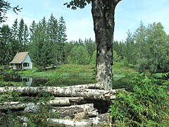
 Typical pond with fisherman's hut
 -
 Grands Prés ponds at La Voivre


References
- ^ (in French) Natacha Ferrer, Plateau des mille étangs - FR4301346 - document d'objectif, Parc naturel régional des Ballons des Vosges, 2008, 109 p.
- ^ (in French) Denis Mathis, « Les enjeux des paysages d’eau dans la construction du Pays des Mille Étangs », Revue Géographique de l'Est, vol.56 / n°1-2, 2016, p. 1-18.
- ^ (in French) Le plateau des Mille Étangs, Natura 2000, Inventaire national du patrimoine naturel (INPN)
External links
Wikimedia Commons has media related to Plateau des Mille Etangs.
- Mille Étangs tourism web site in english


