Puerto Rico Highway 153
Highway in Puerto Rico
Highway 153 | ||||
|---|---|---|---|---|
| Ruta 153 | ||||
| Route information | ||||
| Maintained by Puerto Rico DTPW | ||||
| Length | 14.4 km[1] (8.9 mi) | |||
| Existed | 1953[2]–present | |||
| Major junctions | ||||
| South end |  PR-1 in Santa Isabel barrio-pueblo PR-1 in Santa Isabel barrio-pueblo | |||
| Major intersections |
| |||
| North end |   PR-14 / PR-138 in San Ildefonso PR-14 / PR-138 in San Ildefonso | |||
| Location | ||||
| Country | United States | |||
| Territory | Puerto Rico | |||
| Municipalities | Santa Isabel, Coamo | |||
| Highway system | ||||
| ||||


Puerto Rico Highway 153 (PR-153) is a rural road that goes from Santa Isabel, Puerto Rico to Coamo.[3] This road extends from PR-1 in downtown Santa Isabel and ends at its junction with PR-14 and PR-138 near downtown Coamo.[4]
- Puerto Rico Highway 153 by municipality
-
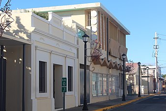
 Heading south in Coamo
 -
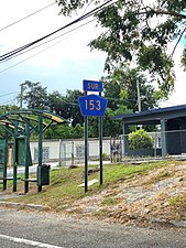
 Heading north in Santa Isabel barrio-pueblo


Major intersections
-
 PR-153 south at PR-52 junction in Santa Isabel
 -
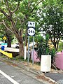 PR-153 south near PR-546 intersection in Coamo
 -
 PR-153 south at PR-546 intersection in Coamo


| Municipality | Location | km[1] | mi | Destinations | Notes |
|---|---|---|---|---|---|
| Santa Isabel | Santa Isabel barrio-pueblo | 0.0 | 0.0 | PR-1 (Calle Luis Muñoz Rivera) – Santa Isabel | Southern terminus of PR-153 |
| 0.2 | 0.12 |  PR-541 (Calle 5 de Octubre) – Santa Isabel PR-541 (Calle 5 de Octubre) – Santa Isabel | |||
| Santa Isabel barrio-pueblo–Boca Velázquez line | 1.1– 1.2 | 0.68– 0.75 |  PR-161 (Desvío Norte Luis Muñoz Marín) – Ponce, Salinas PR-161 (Desvío Norte Luis Muñoz Marín) – Ponce, Salinas | ||
| Felicia 2 | 5.9– 6.0 | 3.7– 3.7 |  PR-545 – Santa Isabel PR-545 – Santa Isabel | Local traffic only | |
| 6.6 | 4.1 |  PR-542 – Santa Isabel PR-542 – Santa Isabel | |||
| 6.7– 6.8 | 4.2– 4.2 |  PR-52 (Autopista Luis A. Ferré) – San Juan, Ponce PR-52 (Autopista Luis A. Ferré) – San Juan, Ponce | PR-52 exit 76; diamond interchange | ||
| Coamo | San Ildefonso | 11.1 | 6.9 |  PR-154 – Río Jueyes PR-154 – Río Jueyes | |
| 12.1 | 7.5 |  PR-546 – Baños de Coamo PR-546 – Baños de Coamo | |||
| 13.0 | 8.1 |   PR-238 east (Desvío Sur de Coamo) – Aibonito PR-238 east (Desvío Sur de Coamo) – Aibonito | Former PR-138 | ||
| 14.4 | 8.9 |  PR-14 (Bulevar Piel Canela) / PR-138 north (Avenida Luis Muñoz Marín) – Coamo, Juana Díaz PR-14 (Bulevar Piel Canela) / PR-138 north (Avenida Luis Muñoz Marín) – Coamo, Juana Díaz | Northern terminus of PR-153; roundabout | ||
1.000 mi = 1.609 km; 1.000 km = 0.621 mi
| |||||
See also
 Puerto Rico portal
 U.S. Roads portal

References
- ^ a b Google (2 March 2020). "PR-153" (Map). Google Maps. Google. Retrieved 2 March 2020.
- ^ "Santa Isabel, Memoria Núm. 40" (PDF). Puerto Rico Planning Board (in Spanish). 1955. Retrieved 4 August 2020.
- ^ National Geographic Maps (2011). Puerto Rico (Map). 1:125,000. Adventure Map (Book 3107). Evergreen, Colorado: National Geographic Maps. ISBN 978-1566955188. OCLC 756511572.
- ^ "Tránsito Promedio Diario (AADT)". Puerto Rico Department of Transportation and Public Works (in Spanish). pp. 82–83. Archived from the original on 1 April 2019. Retrieved 30 May 2019.
External links
 Media related to Puerto Rico Highway 153 at Wikimedia Commons
- v
- t
- e


