Quebec Route 204
Highway in Quebec
You can help expand this article with text translated from the corresponding article in French. (January 2024) Click [show] for important translation instructions.
- Machine translation, like DeepL or Google Translate, is a useful starting point for translations, but translators must revise errors as necessary and confirm that the translation is accurate, rather than simply copy-pasting machine-translated text into the English Wikipedia.
- Do not translate text that appears unreliable or low-quality. If possible, verify the text with references provided in the foreign-language article.
- You must provide copyright attribution in the edit summary accompanying your translation by providing an interlanguage link to the source of your translation. A model attribution edit summary is
Content in this edit is translated from the existing French Wikipedia article at [[:fr:Route 204 (Québec)]]; see its history for attribution. - You may also add the template
{{Translated|fr|Route 204 (Québec)}}to the talk page. - For more guidance, see Wikipedia:Translation.
Major junctions
 R-161 in Lac-Mégantic
 R-269 in Saint-Gédéon-de-Beauce
 R-173 / R-271 in Saint-Georges
  A-73 in Saint-Georges
  R-275 in Saint-Prosper
  R-277 in Sainte-Rose-de-Watford
  R-281 in Saint-Camille-de-Lellis
  R-283 in Saint-Fabien-de-Panet R-283 in Sainte-Lucie-de-Beauregard
  R-285 in Saint-Aldabert
  R-216 in Sainte-Perpetue
 R-132 in Saint-Jean-Port-Joli
- Quebec provincial highways
←  R-203 R-203 | →  R-205 R-205 |
Route 204 is a finite two-lane east–west highway on the south shore of the Saint Lawrence River in Quebec. It is one of the longest secondary highways in the province. Its eastern terminus is in Saint-Jean-Port-Joli at the junction of Route 132 and the western terminus is in Lac-Mégantic at the junction of Route 161. Although it is numbered as an east–west highway, the road follows a north–south course from Saint-Jean-Port-Joli to Saint-Pamphile, where it then follows a mostly southwest–northeast course until Saint-Georges, where after crossing the Chaudière River, follows it in a north–south course until the source of the Chaudiere in Megantic Lake, in Lac-Mégantic.
Municipalities along Route 204
- Lac-Mégantic
- Frontenac
- Audet
- Saint-Ludger
- Saint-Gédéon-de-Beauce
- Saint-Martin
- Saint-Georges
- Saint-Prosper
- Sainte-Rose-de-Watford
- Sainte-Justine
- Saint-Camille-de-Lellis
- Saint-Just-de-Bretenières
- Saint-Fabien-de-Panet
- Sainte-Lucie-de-Beauregard
- Saint-Adalbert
- Saint-Pamphile
- Sainte-Perpétue
- Tourville
- Saint-Damase-de-L'Islet
- Saint-Aubert
- Saint-Jean-Port-Joli
-
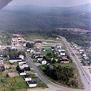 Route 204 bypasses Frontenac.
 -
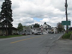 Route 204 in Saint-Martin, near route 269.
 -
 Downtown Saint-Georges with, in the background, Lacroix boulevard (routes 173 and 204) that bypasses it.
 -
 Route 204 in Saint-Camille.
 -
 Bridge over Saint John River in Lac-Frontière.
 -
 Route 204 leaving Tourville.
 -
 Bridge over Trois-Saumons river in Saint-Damase.


Major intersections
| RCM or ET | Municipality | Km | Junction | Notes |
|---|---|---|---|---|
Western terminus of Route 204 | ||||
| Le Granit | Lac-Mégantic | 0.0 | R-161 | 161 SOUTH: to Frontenac 161 NORTH: to Nantes |
| Audet | 21.1 | Chemin-du-Lac-Drolet | NORTH: to Lac-Drolet | |
| Saint-Ludger | 39.1 | 9e Rang | SOUTH: to Saint-Robert-Bellarmin | |
| Beauce-Sartigan | Saint-Gédéon-de-Beauce | 48.8 | R-269 (Overlap 8.9 km) | 269 SOUTH: to Saint-Théophile |
| Saint-Martin | 57.7 | R-269 (Overlap 8.9 km) | 269 NORTH: to Saint-Honoré-de-Shenley | |
| Saint-Georges | 74.0 | R-173 (Overlap 4.4 km) | 173 SOUTH: to Saint-Côme–Linière | |
| 77.2 | R-271 (South end) | 271 NORTH: to Saint-Benoît-Labre | ||
| 78.4 | R-173 (Overlap 4.4 km) | 173 NORTH: to Notre-Dame-des-Pins | ||
| A-73 (South end) | 73 NORTH: to Notre-Dame-des-Pins | |||
| Les Etchemins | Saint-Prosper | 96.9 | R-275 | 275 SOUTH: to Sainte-Aurélie 275 NORTH: to Saint-Benjamin |
| Sainte-Rose-de-Watford | 112.3 117.4 | R-277 | 277 SOUTH: to Saint-Louis-de-Gonzague 277 NORTH: to Lac-Etchemin | |
| Sainte-Justine | 125.3 | Route des Eglises | SOUTH: to Saint-Cyprien | |
| Saint-Camille-de-Lellis | 141.9 | R-281 (South end) | 281 NORTH: to Saint-Magloire | |
| Montmagny | Saint-Just-de-Bretinieres | 155.2 | R-283 | 283 SOUTH: to Lac-Frontière |
| Saint-Fabien-de-Panet | 159.3 | R-283 | 283 NORTH: to Saint-Paul-de-Montminy | |
| Sainte-Lucie-de-Beauregard | 169.3 | R-283 (South end) | 283 NORTH: to Lac-Frontière | |
| L'Islet | Saint-Adalbert | 189.7 | R-285 (South end) | 285 NORTH: to Saint-Marcel |
| Sainte-Perpetue | 221.7 | R-216 (East end) | 216 WEST: to Sainte-Félicité | |
| Saint-Jean-Port-Joli | 260.7 261.2 | | 20 EAST: to Saint-Roch-des-Aulnaies 20 WEST: to L'Islet | |
| 263.9 | R-132 | 132 WEST: to L'Islet 132 EAST: to Saint-Roch-des-Aulnaies | ||
Eastern terminus of Route 204 | ||||
See also
References
- ^ Ministère des transports, "Distances routières", page 80, Les Publications du Québec, 2005
External links
- Provincial Route Map (Courtesy of the Quebec Ministry of Transportation) (in French)
- Route 204 on Google Maps
- v
- t
- e


