Saint-Aubin-du-Cormier
Commune in Brittany, France
Saint-Aubin-du-Cormier Grand'Saent Aubin (Gallo) Sant-Albin-an-Hiliber (Breton) | ||
|---|---|---|
Commune | ||
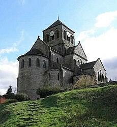 The church of Saint-Aubin, in Saint-Aubin-du-Cormier | ||
 Coat of arms | ||
Location of Saint-Aubin-du-Cormier  | ||
(2020–2026) Jérôme Bégasse[1] | | |
| Area 1 | 27.41 km2 (10.58 sq mi) | |
| Population (2021)[2] | 4,098 | |
| • Density | 150/km2 (390/sq mi) | |
| Time zone | UTC+01:00 (CET) | |
| • Summer (DST) | UTC+02:00 (CEST) | |
| INSEE/Postal code | 35253 /35140 | |
| Elevation | 54–123 m (177–404 ft) (avg. 117 m or 384 ft) | |
| 1 French Land Register data, which excludes lakes, ponds, glaciers > 1 km2 (0.386 sq mi or 247 acres) and river estuaries. | ||
Saint-Aubin-du-Cormier (French pronunciation: [sɛ̃.t‿obɛ̃ dy kɔʁmje]; Gallo: Grand'Saent Aubin, Breton: Sant-Albin-an-Hiliber) is a commune in the Ille-et-Vilaine department in Brittany in northwestern France.
Geography
Saint-Aubin-du-Cormier is located at 29 km (18 mi) northeast of Rennes and 49 km (30 mi) south of Mont Saint-Michel.
The bordering communes are Mézières-sur-Couesnon, Saint-Jean-sur-Couesnon, Saint-Georges-de-Chesné, Mecé, Livré-sur-Changeon, Liffré, Gosné, Ercé-près-Liffré, and Gahard.
History
The area is most notable for the 1488 Battle of Saint-Aubin-du-Cormier, the decisive conflict of the guerre folle between the Duke of Brittany, at the time still independent, and the French king. The Duke Of Brittany Francois II was openly pro England and sought to resist the King of France’s repeated attempts to put an end to Brittany’s independence. Brittany’s forces were defeated, paving the way for the subsequent integration of Brittany into the French kingdom (through the forced marriage of Duchess Anne to the king of France).
The area was also the site of conflict during the Chouannerie, anti-Revolutionary insurrections in the 1790s.
Population
Inhabitants of Saint-Aubin-du-Cormier are called saint-aubinais in French.
| Year | Pop. | ±% p.a. |
|---|---|---|
| 1968 | 1,714 | — |
| 1975 | 1,776 | +0.51% |
| 1982 | 2,235 | +3.34% |
| 1990 | 2,040 | −1.13% |
| 1999 | 2,746 | +3.36% |
| 2007 | 3,608 | +3.47% |
| 2012 | 3,570 | −0.21% |
| 2017 | 3,837 | +1.45% |
| Source: INSEE[3] | ||
See also
References
- ^ "Répertoire national des élus: les maires". data.gouv.fr, Plateforme ouverte des données publiques françaises (in French). 2 December 2020.
- ^ "Populations légales 2021". The National Institute of Statistics and Economic Studies. 28 December 2023.
- ^ Population en historique depuis 1968, INSEE
External links
Wikimedia Commons has media related to Saint-Aubin-du-Cormier.
- Official site (in French)
- Geography of Brittany (in French)
- Base Mérimée: Search for heritage in the commune, Ministère français de la Culture. (in French)
- v
- t
- e

- Acigné
- Amanlis
- Andouillé-Neuville
- Arbrissel
- Argentré-du-Plessis
- Aubigné
- Availles-sur-Seiche
- Baguer-Morvan
- Baguer-Pican
- Bain-de-Bretagne
- Bains-sur-Oust
- Bais
- Balazé
- Baulon
- La Baussaine
- La Bazouge-du-Désert
- Bazouges-la-Pérouse
- Beaucé
- Bécherel
- Bédée
- Betton
- Billé
- Bléruais
- Boisgervilly
- Boistrudan
- Bonnemain
- La Bosse-de-Bretagne
- La Bouëxière
- Bourgbarré
- Bourg-des-Comptes
- La Boussac
- Bovel
- Bréal-sous-Montfort
- Bréal-sous-Vitré
- Brécé
- Breteil
- Brie
- Brielles
- Broualan
- Bruc-sur-Aff
- Les Brulais
- Bruz
- Cancale
- Cardroc
- Cesson-Sévigné
- Champeaux
- Chanteloup
- Chantepie
- La Chapelle-aux-Filtzméens
- La Chapelle-Bouëxic
- La Chapelle-Chaussée
- La Chapelle-de-Brain
- La Chapelle-des-Fougeretz
- La Chapelle-du-Lou-du-Lac
- La Chapelle-Erbrée
- La Chapelle-Fleurigné
- La Chapelle-Saint-Aubert
- La Chapelle-Thouarault
- Chartres-de-Bretagne
- Chasné-sur-Illet
- Châteaubourg
- Châteaugiron
- Châteauneuf-d'Ille-et-Vilaine
- Le Châtellier
- Châtillon-en-Vendelais
- Chauvigné
- Chavagne
- Chelun
- Cherrueix
- Chevaigné
- Cintré
- Clayes
- Coësmes
- Comblessac
- Combourg
- Combourtillé
- Cornillé
- Corps-Nuds
- La Couyère
- Crevin
- Le Crouais
- Cuguen
- Dinard
- Dingé
- Dol-de-Bretagne
- Domagné
- Domalain
- La Dominelais
- Domloup
- Dourdain
- Drouges
- Eancé
- Epiniac
- Erbrée
- Ercé-en-Lamée
- Ercé-près-Liffré
- Essé
- Étrelles
- Feins
- Le Ferré
- Forges-la-Forêt
- Fougèressubpr
- La Fresnais
- Gaël
- Gahard
- Gennes-sur-Seiche
- Gévezé
- Gosné
- La Gouesnière
- Goven
- Grand-Fougeray
- La Guerche-de-Bretagne
- Guichen
- Guignen
- Guipel
- Guipry-Messac
- Hédé-Bazouges
- L'Hermitage
- Hirel
- Iffendic
- Les Iffs
- Irodouër
- Janzé
- Javené
- Laignelet
- Laillé
- Lalleu
- Landavran
- Landéan
- Landujan
- Langan
- Langon
- Langouet
- Lanrigan
- Lassy
- Lécousse
- Lieuron
- Liffré
- Lillemer
- Livré-sur-Changeon
- Lohéac
- Longaulnay
- Le Loroux
- Lourmais
- Loutehel
- Louvigné-de-Bais
- Louvigné-du-Désert
- Luitré-Dompierre
- Maen Roch
- Marcillé-Raoul
- Marcillé-Robert
- Marpiré
- Martigné-Ferchaud
- Maxent
- Mecé
- Médréac
- Meillac
- Melesse
- Mellé
- Mernel
- Mesnil-Roc'h
- La Mézière
- Mézières-sur-Couesnon
- Miniac-Morvan
- Miniac-sous-Bécherel
- Le Minihic-sur-Rance
- Mondevert
- Montauban-de-Bretagne
- Montautour
- Mont-Dol
- Monterfil
- Montfort-sur-Meu
- Montgermont
- Monthault
- Montreuil-des-Landes
- Montreuil-le-Gast
- Montreuil-sous-Pérouse
- Montreuil-sur-Ille
- Mordelles
- Mouazé
- Moulins
- Moussé
- Moutiers
- Muel
- La Noë-Blanche
- La Nouaye
- Nouvoitou
- Noyal-Châtillon-sur-Seiche
- Noyal-sous-Bazouges
- Noyal-sur-Vilaine
- Orgères
- Pacé
- Paimpont
- Pancé
- Parcé
- Parigné
- Parthenay-de-Bretagne
- Le Pertre
- Le Petit-Fougeray
- Pipriac
- Piré-Chancé
- Pléchâtel
- Pleine-Fougères
- Plélan-le-Grand
- Plerguer
- Plesder
- Pleugueneuc
- Pleumeleuc
- Pleurtuit
- Pocé-les-Bois
- Poilley
- Poligné
- Pont-Péan
- Les Portes du Coglais
- Princé
- Québriac
- Quédillac
- Rannée
- Redonsubpr
- Renac
- Rennespref
- Retiers
- Le Rheu
- La Richardais
- Rimou
- Rives-du-Couesnon
- Romagné
- Romazy
- Romillé
- Roz-Landrieux
- Roz-sur-Couesnon
- Sains
- Saint-Armel
- Saint-Aubin-d'Aubigné
- Saint-Aubin-des-Landes
- Saint-Aubin-du-Cormier
- Saint-Benoît-des-Ondes
- Saint-Briac-sur-Mer
- Saint-Brieuc-des-Iffs
- Saint-Broladre
- Saint-Christophe-des-Bois
- Saint-Christophe-de-Valains
- Saint-Coulomb
- Saint-Didier
- Saint-Domineuc
- Sainte-Anne-sur-Vilaine
- Sainte-Colombe
- Sainte-Marie
- Saint-Erblon
- Saint-Ganton
- Saint-Georges-de-Gréhaigne
- Saint-Georges-de-Reintembault
- Saint-Germain-du-Pinel
- Saint-Germain-en-Coglès
- Saint-Germain-sur-Ille
- Saint-Gilles
- Saint-Gondran
- Saint-Gonlay
- Saint-Grégoire
- Saint-Guinoux
- Saint-Hilaire-des-Landes
- Saint-Jacques-de-la-Lande
- Saint-Jean-sur-Vilaine
- Saint-Jouan-des-Guérets
- Saint-Just
- Saint-Léger-des-Prés
- Saint-Lunaire
- Saint-Malosubpr
- Saint-Malo-de-Phily
- Saint-Malon-sur-Mel
- Saint-Marcan
- Saint-Marc-le-Blanc
- Saint-Maugan
- Saint-Médard-sur-Ille
- Saint-Méen-le-Grand
- Saint-Méloir-des-Ondes
- Saint-M'Hervé
- Saint-Onen-la-Chapelle
- Saint-Ouen-des-Alleux
- Saint-Péran
- Saint-Père-Marc-en-Poulet
- Saint-Pern
- Saint-Rémy-du-Plain
- Saint-Sauveur-des-Landes
- Saint-Séglin
- Saint-Senoux
- Saint-Suliac
- Saint-Sulpice-des-Landes
- Saint-Sulpice-la-Forêt
- Saint-Symphorien
- Saint-Thual
- Saint-Thurial
- Saint-Uniac
- Saulnières
- Le Sel-de-Bretagne
- La Selle-en-Luitré
- La Selle-Guerchaise
- Sens-de-Bretagne
- Servon-sur-Vilaine
- Sixt-sur-Aff
- Sougeal
- Taillis
- Talensac
- Teillay
- Le Theil-de-Bretagne
- Thorigné-Fouillard
- Thourie
- Le Tiercent
- Tinténiac
- Torcé
- Trans-la-Forêt
- Treffendel
- Trémeheuc
- Tresbœuf
- Trévérien
- Trimer
- Le Tronchet
- Val-Couesnon
- Val d'Anast
- Val-d'Izé
- Vergéal
- Le Verger
- Vern-sur-Seiche
- Vezin-le-Coquet
- Vieux-Viel
- Vieux-Vy-sur-Couesnon
- Vignoc
- Villamée
- La Ville-ès-Nonais
- Visseiche
- Vitré
- Le Vivier-sur-Mer
- pref: prefecture
- subpr: subprefecture
Authority control databases | |
|---|---|
| International |
|
| National |
|
| Other |
|
 | This Ille-et-Vilaine geographical article is a stub. You can help Wikipedia by expanding it. |
- v
- t
- e


