Saint-Léger-du-Ventoux
Commune in Provence-Alpes-Côte d'Azur, France
Saint-Léger-du-Ventoux Sant Laugier d'Aurenja (Occitan) | ||
|---|---|---|
Commune | ||
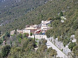 A view of Saint-Léger-du-Ventoux | ||
 Coat of arms | ||
Location of Saint-Léger-du-Ventoux  | ||
(2020–2026) Éric Massot[1] | | |
| Area 1 | 19.29 km2 (7.45 sq mi) | |
| Population (2021)[2] | 29 | |
| • Density | 1.5/km2 (3.9/sq mi) | |
| Time zone | UTC+01:00 (CET) | |
| • Summer (DST) | UTC+02:00 (CEST) | |
| INSEE/Postal code | 84110 /84390 | |
| Elevation | 355–1,901 m (1,165–6,237 ft) (avg. 386 m or 1,266 ft) | |
| 1 French Land Register data, which excludes lakes, ponds, glaciers > 1 km2 (0.386 sq mi or 247 acres) and river estuaries. | ||
Saint-Léger-du-Ventoux (French pronunciation: [sɛ̃ leʒe dy vɑ̃tu]; Occitan: Sant Laugier d'Aurenja;[a] Provençal dialect: Sant Laugier dau Ventor) is a rural commune in the Vaucluse department in the Provence-Alpes-Côte d'Azur region in Southeastern France. In 2019, it had a population of 33. It is located on the departmental border with Drôme, which is also the regional border with Auvergne-Rhône-Alpes.
See also
- Communes of the Vaucluse department
- Mont Ventoux
Notes
- ^ Aurenja is the Occitan name of the neighbouring city of Orange.
References
- ^ "Répertoire national des élus: les maires" (in French). data.gouv.fr, Plateforme ouverte des données publiques françaises. 13 September 2022.
- ^ "Populations légales 2021". The National Institute of Statistics and Economic Studies. 28 December 2023.
Wikimedia Commons has media related to Saint-Léger-du-Ventoux.
- v
- t
- e

- Althen-des-Paluds
- Ansouis
- Aptsubpr
- Aubignan
- Aurel
- Auribeau
- Avignonpref
- Le Barroux
- La Bastide-des-Jourdans
- La Bastidonne
- Le Beaucet
- Beaumes-de-Venise
- Beaumettes
- Beaumont-de-Pertuis
- Beaumont-du-Ventoux
- Bédarrides
- Bédoin
- Blauvac
- Bollène
- Bonnieux
- Brantes
- Buisson
- Buoux
- Cabrières-d'Aigues
- Cabrières-d'Avignon
- Cadenet
- Caderousse
- Cairanne
- Camaret-sur-Aigues
- Caromb
- Carpentrassubpr
- Caseneuve
- Castellet-en-Luberon
- Caumont-sur-Durance
- Cavaillon
- Châteauneuf-de-Gadagne
- Châteauneuf-du-Pape
- Cheval-Blanc
- Courthézon
- Crestet
- Crillon-le-Brave
- Cucuron
- Entraigues-sur-la-Sorgue
- Entrechaux
- Faucon
- Flassan
- Fontaine-de-Vaucluse
- Gargas
- Gignac
- Gigondas
- Gordes
- Goult
- Grambois
- Grillon
- L'Isle-sur-la-Sorgue
- Jonquerettes
- Jonquières
- Joucas
- Lacoste
- Lafare
- Lagarde-d'Apt
- Lagarde-Paréol
- Lagnes
- Lamotte-du-Rhône
- Lapalud
- Lauris
- Lioux
- Loriol-du-Comtat
- Lourmarin
- Malaucène
- Malemort-du-Comtat
- Maubec
- Mazan
- Ménerbes
- Mérindol
- Méthamis
- Mirabeau
- Modène
- Mondragon
- Monieux
- Monteux
- Morières-lès-Avignon
- Mormoiron
- Mornas
- La Motte-d'Aigues
- Murs
- Oppède
- Orange
- Pernes-les-Fontaines
- Pertuis
- Peypin-d'Aigues
- Piolenc
- Le Pontet
- Puget
- Puyméras
- Puyvert
- Rasteau
- Richerenches
- Roaix
- Robion
- La Roque-Alric
- La Roque-sur-Pernes
- Roussillon
- Rustrel
- Sablet
- Saignon
- Saint-Christol
- Saint-Didier
- Sainte-Cécile-les-Vignes
- Saint-Hippolyte-le-Graveyron
- Saint-Léger-du-Ventoux
- Saint-Marcellin-lès-Vaison
- Saint-Martin-de-Castillon
- Saint-Martin-de-la-Brasque
- Saint-Pantaléon
- Saint-Pierre-de-Vassols
- Saint-Romain-en-Viennois
- Saint-Roman-de-Malegarde
- Saint-Saturnin-lès-Apt
- Saint-Saturnin-lès-Avignon
- Saint-Trinit
- Sannes
- Sarrians
- Sault
- Saumane-de-Vaucluse
- Savoillan
- Séguret
- Sérignan-du-Comtat
- Sivergues
- Sorgues
- Suzette
- Taillades
- Le Thor
- La Tour-d'Aigues
- Travaillan
- Uchaux
- Vacqueyras
- Vaison-la-Romaine
- Valréas
- Vaugines
- Vedène
- Velleron
- Venasque
- Viens
- Villars
- Villedieu
- Villelaure
- Villes-sur-Auzon
- Violès
- Visan
- Vitrolles-en-Luberon
- pref: prefecture
- subpr: subprefecture
| Authority control databases: National |
|
|---|
 | This Vaucluse geographical article is a stub. You can help Wikipedia by expanding it. |
- v
- t
- e


