Saint-Régis-du-Coin
Commune in Auvergne-Rhône-Alpes, France
Location of Saint-Régis-du-Coin

(2020–2026) André Vermeersch[1]
1
(2021)[2]
42280 /42660
(avg. 1,070 m or 3,510 ft)
Saint-Régis-du-Coin (French pronunciation: [sɛ̃ ʁeʒis dy kwɛ̃]) is a commune in the Loire department in central France.[3]
Geography
This town of the Loire, which is part of the Pilat Regional Nature Park is located 21 km from Saint-Etienne. His village is situated 1071 m above sea level, so it's a mid-mountain terrain that characterizes the town.
Climate
Because of its location in the uplands, the climate of the St. Regis-du-Coin is harsh in winter (cold and snow) but mild in summer.
History
The town is recent, it dates only from 1858. Its territory was created from plots taken at the town of Marlhes and Saint-Sauveur-en-Rue. Its name comes from a locality called "The Corner" located on this time, near the present town. It added "St. Regis" to forgive, as is the oral tradition, poor reception given to someone who would become St. John Francis Regis, making it the only town in France to carry the name of this apostle of Velay and Vivarais.
Population
| Year | Pop. | ±% p.a. |
|---|---|---|
| 1968 | 333 | — |
| 1975 | 265 | −3.21% |
| 1982 | 292 | +1.40% |
| 1990 | 283 | −0.39% |
| 1999 | 337 | +1.96% |
| 2009 | 375 | +1.07% |
| 2014 | 380 | +0.27% |
| 2020 | 411 | +1.32% |
| Source: INSEE[4] | ||
Sights
- The bogs of Gimel.
- Bogs of Gimel are a protected site, because they are the largest wetland of the Natural Park of Pilat. Rectangular pits are the mark of a former exploitation, as the hydraulic network witness of the necessary drainage.
- Mount Chaussitre
Galleries
- Bogs
-
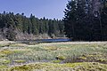 Floating bog, South view.
 -
 Floating bog, East view.


See also
References
- ^ "Répertoire national des élus: les maires". data.gouv.fr, Plateforme ouverte des données publiques françaises (in French). 2 December 2020.
- ^ "Populations légales 2021". The National Institute of Statistics and Economic Studies. 28 December 2023.
- ^ INSEE commune file
- ^ Population en historique depuis 1968, INSEE
Wikimedia Commons has media related to Saint-Régis-du-Coin.
- v
- t
- e
Communes of the Loire department 

- Aboën
- Ailleux
- Ambierle
- Andrézieux-Bouthéon
- Apinac
- Arcinges
- Arcon
- Arthun
- Aveizieux
- Balbigny
- Bard
- Bellegarde-en-Forez
- Belleroche
- Belmont-de-la-Loire
- La Bénisson-Dieu
- Le Bessat
- Bessey
- Boën-sur-Lignon
- Boisset-lès-Montrond
- Boisset-Saint-Priest
- Bonson
- Bourg-Argental
- Boyer
- Briennon
- Bully
- Burdignes
- Bussières
- Bussy-Albieux
- Çaloire
- Cellieu
- Le Cergne
- Cervières
- Cezay
- Chagnon
- Chalain-d'Uzore
- Chalain-le-Comtal
- Chalmazel-Jeansagnière
- La Chamba
- Chambéon
- Chambles
- Chambœuf
- Le Chambon-Feugerolles
- La Chambonie
- Champdieu
- Champoly
- Chandon
- Changy
- La Chapelle-en-Lafaye
- La Chapelle-Villars
- Charlieu
- Châteauneuf
- Châtelneuf
- Châtelus
- Chausseterre
- Chavanay
- Chazelles-sur-Lavieu
- Chazelles-sur-Lyon
- Chenereilles
- Cherier
- Chevrières
- Chirassimont
- Chuyer
- Civens
- Cleppé
- Colombier
- Combre
- Commelle-Vernay
- Cordelle
- La Côte-en-Couzan
- Le Coteau
- Cottance
- Coutouvre
- Craintilleux
- Cremeaux
- Croizet-sur-Gand
- Le Crozet
- Cuinzier
- Cuzieu
- Dargoire
- Débats-Rivière-d'Orpra
- Doizieux
- Écoche
- Écotay-l'Olme
- Épercieux-Saint-Paul
- Essertines-en-Châtelneuf
- Essertines-en-Donzy
- Estivareilles
- L'Étrat
- Farnay
- Feurs
- Firminy
- Fontanès
- La Fouillouse
- Fourneaux
- Fraisses
- Genilac
- La Gimond
- Graix
- Grammond
- La Grand-Croix
- La Gresle
- Grézieux-le-Fromental
- Grézolles
- Gumières
- L'Hôpital-le-Grand
- L'Hôpital-sous-Rochefort
- L'Horme
- Jarnosse
- Jas
- Jonzieux
- Juré
- Lavieu
- Lay
- Leigneux
- Lentigny
- Lérigneux
- Lézigneux
- Lorette
- Lupé
- Luré
- Luriecq
- Mably
- Machézal
- Maclas
- Magneux-Haute-Rive
- Maizilly
- Malleval
- Marcenod
- Marcilly-le-Châtel
- Marclopt
- Marcoux
- Margerie-Chantagret
- Maringes
- Marlhes
- Marols
- Mars
- Merle-Leignec
- Mizérieux
- Montagny
- Montarcher
- Montbrisonsubpr
- Montchal
- Montrond-les-Bains
- Montverdun
- Mornand-en-Forez
- Nandax
- Neaux
- Néronde
- Nervieux
- Neulise
- Noailly
- Les Noës
- Noirétable
- Nollieux
- Notre-Dame-de-Boisset
- Ouches
- La Pacaudière
- Palogneux
- Panissières
- Parigny
- Pavezin
- Pélussin
- Périgneux
- Perreux
- Pinay
- Planfoy
- Pommiers-en-Forez
- Poncins
- Pouilly-lès-Feurs
- Pouilly-les-Nonains
- Pouilly-sous-Charlieu
- Pradines
- Pralong
- Précieux
- Régny
- Renaison
- La Ricamarie
- Riorges
- Rivas
- Rive-de-Gier
- Roannesubpr
- Roche
- Roche-la-Molière
- Roisey
- Rozier-Côtes-d'Aurec
- Rozier-en-Donzy
- Sail-les-Bains
- Sail-sous-Couzan
- Saint-Alban-les-Eaux
- Saint-André-d'Apchon
- Saint-André-le-Puy
- Saint-Appolinard
- Saint-Barthélemy-Lestra
- Saint-Bonnet-des-Quarts
- Saint-Bonnet-le-Château
- Saint-Bonnet-le-Courreau
- Saint-Bonnet-les-Oules
- Saint-Chamond
- Saint-Christo-en-Jarez
- Saint-Cyprien
- Saint-Cyr-de-Favières
- Saint-Cyr-de-Valorges
- Saint-Cyr-les-Vignes
- Saint-Denis-de-Cabanne
- Saint-Denis-sur-Coise
- Saint-Didier-sur-Rochefort
- Sainte-Agathe-en-Donzy
- Sainte-Agathe-la-Bouteresse
- Sainte-Colombe-sur-Gand
- Sainte-Croix-en-Jarez
- Sainte-Foy-Saint-Sulpice
- Saint-Étiennepref
- Saint-Étienne-le-Molard
- Saint-Forgeux-Lespinasse
- Saint-Galmier
- Saint-Genest-Lerpt
- Saint-Genest-Malifaux
- Saint-Georges-de-Baroille
- Saint-Georges-en-Couzan
- Saint-Georges-Haute-Ville
- Saint-Germain-la-Montagne
- Saint-Germain-Laval
- Saint-Germain-Lespinasse
- Saint-Haon-le-Châtel
- Saint-Haon-le-Vieux
- Saint-Héand
- Saint-Hilaire-Cusson-la-Valmitte
- Saint-Hilaire-sous-Charlieu
- Saint-Jean-Bonnefonds
- Saint-Jean-la-Vêtre
- Saint-Jean-Saint-Maurice-sur-Loire
- Saint-Jean-Soleymieux
- Saint-Jodard
- Saint-Joseph
- Saint-Julien-d'Oddes
- Saint-Julien-Molin-Molette
- Saint-Just-en-Bas
- Saint-Just-en-Chevalet
- Saint-Just-la-Pendue
- Saint-Just-Saint-Rambert
- Saint-Laurent-la-Conche
- Saint-Laurent-Rochefort
- Saint-Léger-sur-Roanne
- Saint-Marcel-de-Félines
- Saint-Marcel-d'Urfé
- Saint-Marcellin-en-Forez
- Saint-Martin-d'Estréaux
- Saint-Martin-la-Plaine
- Saint-Martin-la-Sauveté
- Saint-Martin-Lestra
- Saint-Maurice-en-Gourgois
- Saint-Médard-en-Forez
- Saint-Michel-sur-Rhône
- Saint-Nizier-de-Fornas
- Saint-Nizier-sous-Charlieu
- Saint-Paul-d'Uzore
- Saint-Paul-en-Cornillon
- Saint-Paul-en-Jarez
- Saint-Pierre-de-Bœuf
- Saint-Pierre-la-Noaille
- Saint-Polgues
- Saint-Priest-en-Jarez
- Saint-Priest-la-Prugne
- Saint-Priest-la-Roche
- Saint-Priest-la-Vêtre
- Saint-Régis-du-Coin
- Saint-Rirand
- Saint-Romain-d'Urfé
- Saint-Romain-en-Jarez
- Saint-Romain-la-Motte
- Saint-Romain-le-Puy
- Saint-Romain-les-Atheux
- Saint-Sauveur-en-Rue
- Saint-Sixte
- Saint-Symphorien-de-Lay
- Saint-Thomas-la-Garde
- Saint-Victor-sur-Rhins
- Saint-Vincent-de-Boisset
- Les Salles
- Salt-en-Donzy
- Salvizinet
- Sauvain
- Savigneux
- Sevelinges
- Soleymieux
- Sorbiers
- Souternon
- Sury-le-Comtal
- La Talaudière
- Tarentaise
- Tartaras
- La Terrasse-sur-Dorlay
- Thélis-la-Combe
- La Tour-en-Jarez
- La Tourette
- Trelins
- La Tuilière
- Unias
- Unieux
- Urbise
- Usson-en-Forez
- Valeille
- Valfleury
- La Valla-en-Gier
- La Valla-sur-Rochefort
- Veauche
- Veauchette
- Vendranges
- Véranne
- Vérin
- Verrières-en-Forez
- La Versanne
- Vêtre-sur-Anzon
- Vézelin-sur-Loire
- Villars
- Villemontais
- Villerest
- Villers
- Violay
- Viricelles
- Virigneux
- Vivans
- Vougy
- pref: prefecture
- subpr: subprefecture
Authority control databases | |
|---|---|
| International |
|
| National |
|
| Other |
|
 | This Loire geographical article is a stub. You can help Wikipedia by expanding it. |
- v
- t
- e


