Sartène
Subprefecture and commune in Corsica, France
You can help expand this article with text translated from the corresponding article in Corsican. (January 2009) Click [show] for important translation instructions.
- View a machine-translated version of the Corsican article.
- Machine translation, like DeepL or Google Translate, is a useful starting point for translations, but translators must revise errors as necessary and confirm that the translation is accurate, rather than simply copy-pasting machine-translated text into the English Wikipedia.
- Do not translate text that appears unreliable or low-quality. If possible, verify the text with references provided in the foreign-language article.
- You must provide copyright attribution in the edit summary accompanying your translation by providing an interlanguage link to the source of your translation. A model attribution edit summary is
Content in this edit is translated from the existing Corsican Wikipedia article at [[:co:Sartè]]; see its history for attribution. - You may also add the template
{{Translated|co|Sartè}}to the talk page. - For more guidance, see Wikipedia:Translation.
Subprefecture and commune in Corsica, France
Sartène Sartè (Corsican) | ||
|---|---|---|
Subprefecture and commune | ||
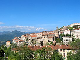 A general view of Sartène | ||
 Coat of arms | ||
Location of Sartène  | ||
(2020–2026) Paul Quilichini[1] | | |
| Area 1 | 200.4 km2 (77.4 sq mi) | |
| Population (2021)[2] | 3,570 | |
| • Density | 18/km2 (46/sq mi) | |
| Time zone | UTC+01:00 (CET) | |
| • Summer (DST) | UTC+02:00 (CEST) | |
| INSEE/Postal code | 2A272 /20100 | |
| Elevation | 0–1,320 m (0–4,331 ft) (avg. 330 m or 1,080 ft) | |
| 1 French Land Register data, which excludes lakes, ponds, glaciers > 1 km2 (0.386 sq mi or 247 acres) and river estuaries. | ||
Sartène (French: [saʁtɛn]; Corsican: Sartè [sarˈtɛ]; Italian: Sartena [sarˈtɛːna] or Sartene [sarˈtɛːne][3][4]) is a commune in the department of Corse-du-Sud on the island of Corsica, France.
Its history dates back to medieval times and granite buildings from the early 16th century still line some of the streets. One of the main incidents in the town's history was an attack by pirates from Algiers in 1583, after which 400 people were taken away. These attacks continued into the 18th century.
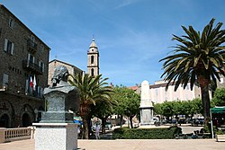
The town is centred on the Place de la Liberation (previously the Place Porta), at the edge of which is the church of Sainte Marie. The town allows good views across the valley. Sartène wine is appreciated by wine connoisseurs for its good quality.
Sartène has given its name to one of the southern Corsican dialects a variety of which is the Gallurese spoken in North Sardinia.
Geography
Climate
Sartène has a mediterranean climate (Köppen climate classification Csa). The average annual temperature in Sartène is 15.8 °C (60.4 °F). The average annual rainfall is 732.1 mm (28.82 in) with November as the wettest month. The temperatures are highest on average in August, at around 23.9 °C (75.0 °F), and lowest in February, at around 8.9 °C (48.0 °F). The highest temperature ever recorded in Sartène was 43.4 °C (110.1 °F) on 23 July 2009; the coldest temperature ever recorded was −4.8 °C (23.4 °F) on 1 February 1999.
| Climate data for Sartène (1991–2020 averages, extremes 1996−present) | |||||||||||||
|---|---|---|---|---|---|---|---|---|---|---|---|---|---|
| Month | Jan | Feb | Mar | Apr | May | Jun | Jul | Aug | Sep | Oct | Nov | Dec | Year |
| Record high °C (°F) | 21.4 (70.5) | 23.5 (74.3) | 29.8 (85.6) | 31.1 (88.0) | 36.4 (97.5) | 40.1 (104.2) | 43.4 (110.1) | 42.1 (107.8) | 37.1 (98.8) | 34.7 (94.5) | 26.9 (80.4) | 22.4 (72.3) | 43.4 (110.1) |
| Mean daily maximum °C (°F) | 13.6 (56.5) | 14.0 (57.2) | 16.4 (61.5) | 19.2 (66.6) | 23.3 (73.9) | 28.0 (82.4) | 30.6 (87.1) | 30.9 (87.6) | 26.7 (80.1) | 23.0 (73.4) | 17.9 (64.2) | 14.5 (58.1) | 21.5 (70.7) |
| Daily mean °C (°F) | 9.0 (48.2) | 8.9 (48.0) | 11.0 (51.8) | 13.6 (56.5) | 17.3 (63.1) | 21.3 (70.3) | 23.7 (74.7) | 23.9 (75.0) | 20.6 (69.1) | 17.5 (63.5) | 13.2 (55.8) | 10.0 (50.0) | 15.8 (60.4) |
| Mean daily minimum °C (°F) | 4.3 (39.7) | 3.9 (39.0) | 5.6 (42.1) | 8.1 (46.6) | 11.3 (52.3) | 14.6 (58.3) | 16.7 (62.1) | 17.0 (62.6) | 14.5 (58.1) | 12.0 (53.6) | 8.5 (47.3) | 5.5 (41.9) | 10.2 (50.4) |
| Record low °C (°F) | −4.6 (23.7) | −4.8 (23.4) | −3.8 (25.2) | −1.9 (28.6) | 3.9 (39.0) | 5.9 (42.6) | 8.6 (47.5) | 10.3 (50.5) | 7.0 (44.6) | 0.4 (32.7) | −4.7 (23.5) | −4.3 (24.3) | −4.8 (23.4) |
| Average precipitation mm (inches) | 73.6 (2.90) | 58.2 (2.29) | 57.1 (2.25) | 54.9 (2.16) | 57.2 (2.25) | 29.6 (1.17) | 9.3 (0.37) | 18.1 (0.71) | 58.2 (2.29) | 88.8 (3.50) | 129.3 (5.09) | 97.8 (3.85) | 732.1 (28.82) |
| Average precipitation days (≥ 1.0 mm) | 8.9 | 8.1 | 7.6 | 7.3 | 5.8 | 3.3 | 1.1 | 2.2 | 5.6 | 7.0 | 10.9 | 9.3 | 76.9 |
| Source: Météo France[5] | |||||||||||||
Population
|
| |||||||||||||||||||||||||||||||||||||||||||||||||||||||||||||||||||||||||||||||||||||||||||||||||||||||||||||||
| Source: EHESS[6] and INSEE (1968-2017)[7] | ||||||||||||||||||||||||||||||||||||||||||||||||||||||||||||||||||||||||||||||||||||||||||||||||||||||||||||||||
Sights
Genoese towers in the commune of Sartène:
There are numerous archaeological sites in the commune or Sartène:
See also
References
- ^ "Répertoire national des élus: les maires". data.gouv.fr, Plateforme ouverte des données publiques françaises (in French). 2 December 2020.
- ^ "Populations légales 2021". The National Institute of Statistics and Economic Studies. 28 December 2023.
- ^ Luciano Canepari. "Sartena". DiPI Online (in Italian). Retrieved 16 January 2021.
- ^ Luciano Canepari. "Sartene". DiPI Online (in Italian). Retrieved 16 January 2021.
- ^ "climate of Sartène 1991-2020" (PDF) (in French). Météo-France. Retrieved 1 June 2022.
- ^ Des villages de Cassini aux communes d'aujourd'hui: Commune data sheet Sartène, EHESS (in French).
- ^ Population en historique depuis 1968, INSEE
External links
- A page on the history of the town
- Corsican Dolmens (in English and Italian)
Wikimedia Commons has media related to Sartène.
- v
- t
- e

- Afa
- Ajacciopref
- Alata
- Albitreccia
- Altagène
- Ambiegna
- Appietto
- Arbellara
- Arbori
- Argiusta-Moriccio
- Arro
- Aullène
- Azilone-Ampaza
- Azzana
- Balogna
- Bastelica
- Bastelicaccia
- Belvédère-Campomoro
- Bilia
- Bocognano
- Bonifacio
- Calcatoggio
- Campo
- Cannelle
- Carbini
- Carbuccia
- Cardo-Torgia
- Cargèse
- Cargiaca
- Casaglione
- Casalabriva
- Cauro
- Ciamannacce
- Coggia
- Cognocoli-Monticchi
- Conca
- Corrano
- Coti-Chiavari
- Cozzano
- Cristinacce
- Cuttoli-Corticchiato
- Eccica-Suarella
- Évisa
- Figari
- Foce
- Forciolo
- Fozzano
- Frasseto
- Giuncheto
- Granace
- Grossa
- Grosseto-Prugna
- Guagno
- Guargualé
- Guitera-les-Bains
- Lecci
- Letia
- Levie
- Lopigna
- Loreto-di-Tallano
- Marignana
- Mela
- Moca-Croce
- Monacia-d'Aullène
- Murzo
- Ocana
- Olivese
- Olmeto
- Olmiccia
- Orto
- Osani
- Ota
- Palneca
- Partinello
- Pastricciola
- Peri
- Petreto-Bicchisano
- Piana
- Pianottoli-Caldarello
- Pietrosella
- Pila-Canale
- Poggiolo
- Porto-Vecchio
- Propriano
- Quasquara
- Quenza
- Renno
- Rezza
- Rosazia
- Sainte-Lucie-de-Tallano
- Salice
- Sampolo
- San-Gavino-di-Carbini
- Santa-Maria-Figaniella
- Santa-Maria-Siché
- Sant'Andréa-d'Orcino
- Sari-d'Orcino
- Sari-Solenzara
- Sarrola-Carcopino
- Sartènesubpr
- Serra-di-Ferro
- Serra-di-Scopamène
- Serriera
- Soccia
- Sollacaro
- Sorbollano
- Sotta
- Tasso
- Tavaco
- Tavera
- Tolla
- Ucciani
- Urbalacone
- Valle-di-Mezzana
- Vero
- Vico
- Viggianello
- Villanova
- Zérubia
- Zévaco
- Zicavo
- Zigliara
- Zonza
- Zoza
- pref: prefecture
- subpr: subprefecture
Authority control databases | |
|---|---|
| International |
|
| National |
|
| Geographic |
|
 | This Corse-du-Sud geographical article is a stub. You can help Wikipedia by expanding it. |
- v
- t
- e


