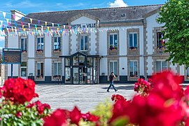
Scaër
Scaër Skaer | ||
|---|---|---|
Commune | ||
 Town hall | ||
 Flag  Coat of arms | ||
Location of Scaër  | ||
(2020–2026) Jean-Yves Le Goff[1] | | |
| Area 1 | 117.58 km2 (45.40 sq mi) | |
| Population (2021)[2] | 5,223 | |
| • Density | 44/km2 (120/sq mi) | |
| Time zone | UTC+01:00 (CET) | |
| • Summer (DST) | UTC+02:00 (CEST) | |
| INSEE/Postal code | 29274 /29390 | |
| Elevation | 65–242 m (213–794 ft) | |
| 1 French Land Register data, which excludes lakes, ponds, glaciers > 1 km2 (0.386 sq mi or 247 acres) and river estuaries. | ||
Scaër (French pronunciation: [skɛʁ]; Breton: Skaer) is a commune in the Finistère department of Brittany in north-western France.
Population
Inhabitants of Scaër are called in French Scaërois. Scaër's population peaked at 7,838 in 1946 and has since declined to 5,245 in 2020. This represents a 33% decrease in total population since the peak census figure.
|
| ||||||||||||||||||||||||||||||||||||||||||||||||||||||||||||||||||||||||||||||||||||||||||||||||||||||||||||||||||
| |||||||||||||||||||||||||||||||||||||||||||||||||||||||||||||||||||||||||||||||||||||||||||||||||||||||||||||||||||
| Source: EHESS[3] and INSEE (1968–2019)[4] | |||||||||||||||||||||||||||||||||||||||||||||||||||||||||||||||||||||||||||||||||||||||||||||||||||||||||||||||||||
Geography
Scaër, encompassing 11,758 hectares, is the most spread-out city in Finistère and the third in Brittany. Scaër is located 30.5 km (19.0 mi) east of Quimper and 40 km (25 mi) northwest of Lorient. Historically, Scaër belongs to Cornouaille.
Neighbouring communes
Scaër is border by Guiscriff to the east, by Leuhan and Roudouallec to the north, by Tourc'h to the west and by Rosporden and Bannalec to the south.
Breton language
The municipality launched a linguistic plan concerning the Breton language through Ya d'ar brezhoneg on 20 March 2007.
In 2008, 11.62% of primary-school children attended bilingual schools.[5]
See also
References
- ^ "Répertoire national des élus: les maires" (in French). data.gouv.fr, Plateforme ouverte des données publiques françaises. 13 September 2022.
- ^ "Populations légales 2021". The National Institute of Statistics and Economic Studies. 28 December 2023.
- ^ Des villages de Cassini aux communes d'aujourd'hui: Commune data sheet Scaër, EHESS (in French).
- ^ Population en historique depuis 1968, INSEE
- ^ (in French) Ofis ar Brezhoneg: Enseignement bilingue
External links

- Official website (in French)
- Base Mérimée: Search for heritage in the commune, Ministère français de la Culture. (in French)
- Mayors of Finistère Association (in French)
- v
- t
- e
- Argol
- Arzano
- Audierne
- Bannalec
- Baye
- Bénodet
- Berrien
- Beuzec-Cap-Sizun
- Bodilis
- Bohars
- Bolazec
- Botmeur
- Botsorhel
- Bourg-Blanc
- Brasparts
- Brélès
- Brennilis
- Brestsubpr
- Briec
- Camaret-sur-Mer
- Carantec
- Carhaix-Plouguer
- Cast
- Châteaulinsubpr
- Châteauneuf-du-Faou
- Cléden-Cap-Sizun
- Cléden-Poher
- Cléder
- Clohars-Carnoët
- Clohars-Fouesnant
- Le Cloître-Pleyben
- Le Cloître-Saint-Thégonnec
- Coat-Méal
- Collorec
- Combrit
- Commana
- Concarneau
- Confort-Meilars
- Le Conquet
- Coray
- Crozon
- Daoulas
- Dinéault
- Dirinon
- Douarnenez
- Le Drennec
- Edern
- Elliant
- Ergué-Gabéric
- Le Faou
- La Feuillée
- Le Folgoët
- La Forest-Landerneau
- La Forêt-Fouesnant
- Fouesnant
- Garlan
- Gouesnac'h
- Gouesnou
- Gouézec
- Goulien
- Goulven
- Gourlizon
- Guengat
- Guerlesquin
- Guiclan
- Guilers
- Guiler-sur-Goyen
- Guilligomarc'h
- Guilvinec
- Guimaëc
- Guimiliau
- Guipavas
- Guissény
- Hanvec
- Henvic
- Hôpital-Camfrout
- Huelgoat
- Île de Batz
- Île de Sein
- Île-Tudy
- Irvillac
- Le Juch
- Kergloff
- Kerlaz
- Kerlouan
- Kernilis
- Kernouës
- Kersaint-Plabennec
- Lampaul-Guimiliau
- Lampaul-Plouarzel
- Lampaul-Ploudalmézeau
- Lanarvily
- Landéda
- Landeleau
- Landerneau
- Landévennec
- Landivisiau
- Landrévarzec
- Landudal
- Landudec
- Landunvez
- Langolen
- Lanhouarneau
- Lanildut
- Lanmeur
- Lannéanou
- Lannédern
- Lanneuffret
- Lannilis
- Lanrivoaré
- Lanvéoc
- Laz
- Lennon
- Lesneven
- Leuhan
- Loc-Brévalaire
- Loc-Eguiner
- Locmaria-Plouzané
- Locmélar
- Locquénolé
- Locquirec
- Locronan
- Loctudy
- Locunolé
- Logonna-Daoulas
- Lopérec
- Loperhet
- Loqueffret
- Lothey
- Mahalon
- La Martyre
- Melgven
- Mellac
- Mespaul
- Milizac-Guipronvel
- Moëlan-sur-Mer
- Molène
- Morlaixsubpr
- Motreff
- Névez
- Ouessant
- Pencran
- Penmarch
- Peumerit
- Plabennec
- Pleuven
- Pleyben
- Pleyber-Christ
- Plobannalec-Lesconil
- Ploéven
- Plogastel-Saint-Germain
- Plogoff
- Plogonnec
- Plomelin
- Plomeur
- Plomodiern
- Plonéis
- Plonéour-Lanvern
- Plonévez-du-Faou
- Plonévez-Porzay
- Plouarzel
- Ploudalmézeau
- Ploudaniel
- Ploudiry
- Plouédern
- Plouégat-Guérand
- Plouégat-Moysan
- Plouénan
- Plouescat
- Plouezoc'h
- Plougar
- Plougasnou
- Plougastel-Daoulas
- Plougonvelin
- Plougonven
- Plougoulm
- Plougourvest
- Plouguerneau
- Plouguin
- Plouhinec
- Plouider
- Plouigneau
- Ploumoguer
- Plounéour-Brignogan-Plages
- Plounéour-Ménez
- Plounéventer
- Plounévézel
- Plounévez-Lochrist
- Plourin
- Plourin-lès-Morlaix
- Plouvien
- Plouvorn
- Plouyé
- Plouzané
- Plouzévédé
- Plovan
- Plozévet
- Pluguffan
- Pont-Aven
- Pont-Croix
- Pont-de-Buis-lès-Quimerch
- Pont-l'Abbé
- Porspoder
- Port-Launay
- Pouldergat
- Pouldreuzic
- Poullan-sur-Mer
- Poullaouen
- Primelin
- Quéménéven
- Querrien
- Quimperpref
- Quimperlé
- Rédené
- Le Relecq-Kerhuon
- Riec-sur-Bélon
- La Roche-Maurice
- Roscanvel
- Roscoff
- Rosnoën
- Rosporden
- Saint-Coulitz
- Saint-Derrien
- Saint-Divy
- Saint-Eloy
- Sainte-Sève
- Saint-Évarzec
- Saint-Frégant
- Saint-Goazec
- Saint-Hernin
- Saint-Jean-du-Doigt
- Saint-Jean-Trolimon
- Saint-Martin-des-Champs
- Saint-Méen
- Saint-Nic
- Saint-Pabu
- Saint-Pol-de-Léon
- Saint-Renan
- Saint-Rivoal
- Saint-Sauveur
- Saint-Ségal
- Saint-Servais
- Saint-Thégonnec Loc-Eguiner
- Saint-Thois
- Saint-Thonan
- Saint-Thurien
- Saint-Urbain
- Saint-Vougay
- Saint-Yvi
- Santec
- Scaër
- Scrignac
- Sibiril
- Sizun
- Spézet
- Taulé
- Telgruc-sur-Mer
- Tourch
- Trébabu
- Treffiagat
- Tréflaouénan
- Tréflévénez
- Tréflez
- Trégarantec
- Trégarvan
- Tréglonou
- Trégourez
- Tréguennec
- Trégunc
- Le Tréhou
- Trémaouézan
- Tréméoc
- Tréméven
- Tréogat
- Tréouergat
- Le Trévoux
- Trézilidé
- pref: prefecture
- subpr: subprefecture
 | This Finistère geographical article is a stub. You can help Wikipedia by expanding it. |
- v
- t
- e


