Sint-Martens-Latem
Municipality in Flemish Community, Belgium

Flag

Coat of arms
Location of Sint-Martens-Latem


Sint-Martens-Latem
Location in Belgium 
Location of Sint-Martens-Latem in East Flanders

 Belgium
 (2018-01-01)[1]
9830, 9831
44064
Sint-Martens-Latem (Dutch pronunciation: [sɪnt ˌmɑrtəns ˈlaːtəm] ⓘ) is a municipality located in the Belgian province of East Flanders, in Belgium. The municipality comprises the towns of Deurle and Sint-Martens-Latem proper. In 2021, Sint-Martens-Latem had a total population of 8,285. The total area is 14.34 km2.[2]
While "Latem" used to be known as an artists' colony before World War II, nowadays Sint-Martens-Latem is one of the wealthiest residential municipalities in Belgium.
Notable people
- Luc-Peter Crombé, painter
- Gustave De Smet, painter
- George Minne, sculptor and artist
- Constant Permeke, painter
- Gustave Van de Woestijne, painter
- Rudolf Werthen, violinist & conductor
Gallery
-
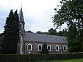 Sint-Aldegondischurch in Deurle
 -
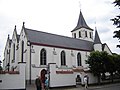 Sint-Martinuschurch in Sint-Martens-Latem
 -
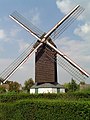 Koutermolen, Latemse Molen, Sint-Baafsmolen, a post mill


References
External links
 Media related to Sint-Martens-Latem at Wikimedia Commons
- (in Dutch) Official website


- v
- t
- e

- Aalter
- Deinze
- De Pinte
- Destelbergen
- Evergem
- Gavere
- Ghent
- Lievegem
- Lochristi
- Melle
- Merelbeke
- Moerbeke-Waas
- Nazareth
- Oosterzele
- Sint-Martens-Latem
- Wachtebeke
- Zulte
- Bold indicates cities
- Italic indicates municipality with language facilities
Authority control databases | |
|---|---|
| International |
|
| National |
|
| Geographic |
|
| Other |
|
 | This East Flanders location article is a stub. You can help Wikipedia by expanding it. |
- v
- t
- e


