Sohar
An Omani city on the coast of the Gulf of Oman
City in Al Batinah North, Oman
Sohar Ṣuḥār (صُحَار) | |
|---|---|
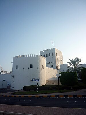 The fort at Al-Hujrah | |
24°20′31.2″N 56°43′47.6″E / 24.342000°N 56.729889°E / 24.342000; 56.729889 | |
| Country |  Oman Oman |
| Governorate | Al Batinah North |
| Elevation | 4 m (13 ft) |
| Population (2016) | |
| • Total | 221,605 |
| Time zone | UTC+4 (Oman Standard Time) |
Sohar (Arabic: صُحَار, romanized: Ṣuḥār) is the capital and largest city of the Al Batinah North Governorate in Oman. An ancient capital of the country that once served as an important Islamic port town on the Gulf of Oman,[4] Sohar has also been credited as the mythical birthplace of Sinbad the Sailor.[5] It was historically known as Mazūn (مَزُوْن).[1][2][3]
At the 2010 census, Sohar's population was 140,006, making it Oman's fifth most-populated settlement.[6] Described as an industrial town,[7] the development of the Sohar Industrial Port during the 2000s has transformed it into a major Omani industrial hub.
History

As the largest town in the region, it has been argued that Sohar is to be identified with the ancient town called 'Omanah' (Arabic: عُمَانَة) mentioned by Pliny the Elder in his Natural History. This settlement is believed to have given Oman its name.[8]
According to Al-Tabari, in 893 or 894, during the Abbasid era, there was a dispute about who should rule Oman amongst local factions. A faction that approached the Abbasids was the Bani Sama, who were based in Al-Buraimi or Tawam, before moving to Sohar. Bani Sama also referred to themselves as the Wajihid Dynasty, and assumed leadership over the region. The present-day town of Buraimi is part of a historical region that Tabari referred to as 'Tawam', which nowadays also includes the adjacent U.A.E. city of Al Ain.[9]
By the 10th century, Sohar was one of the richest ports of the Persian Gulf. It was praised by Ibn Hawqal and Al-Maqdisi, who called it "flourishing, populous, beautiful, pleasant and delightful", and compared it favourably with the ports of China. Aloes, wood, bamboo, sandalwood and spices were brought from India and frankincense from Dhofar. The city was sacked by the Buwayhids in 971 and its trade went into decline. It also suffered from attacks by the merchants of Kish across the gulf, who briefly took control of the city around 1100. Sohar then became the initial seat of the Sultanate of Sohar, under the rule of the Bani Nabhan dynasty. They achieved ascendancy after being appointed governors of Sohar by their Buyid suzerains.[10] The city's famous fort was constructed in the late 13th century by the "Princes of Hormuz" while the city remained under Nabhani control.[11] The two entities maintained an agreement over maritime and internal control of Oman.[10] After a period of ruin, Sohar was re-established in the 15th century as a minor port under the Hormuzi-Qalhati sphere of influence.[10] It was still an international port until at least the 16th century.[12]
Portuguese occupation
In the early 16th century, Sohar was conquered by the Portuguese Empire, which used the city to control the entrances to the Arabian Gulf and trade in the region. It was part of a web of fortresses controlled by the Portuguese, from Bahrain to Hormuz, and was depicted in António Bocarro's 17th-century Book of Fortresses.[13]
Recent history
Starting on 26 February 2011, Sohar was the site of mass protests, part of the Arab Spring uprisings. Although protests also occurred in Muscat and Salalah, the Sohar protests were the biggest in the country, attracting an estimated 2,000 people at times.[14] The protesters' initial demands were for more job opportunities and greater political participation; later demonstrations also called for the release of detained protesters and an inquiry into the use of violence by security forces.[15] The protests centered on Sohar's Globe Roundabout. In response, Sultan Qaboos announced reforms and a jobs program, and reshuffled the Omani cabinet.[14]
Infrastructure
Industry
A number of enterprises and investment projects in Sohar are centred around the Port of Sohar. Established in 2002, the port has a strategic importance due to its nearness to the Strait of Hormuz. It is operated by the Sohar Industrial Port Company (SIPC). With current investments exceeding $12 billion, it is one of the world’s largest port development projects. The port's container terminal, managed by Hutchison Ports[16] handles the majority of the container cargo of North Al Batinah region of the Sultanate.
The industrial development of Sohar was prioritised in the Omani Government's economic development plan in 2020. Investments include more than $5 billion in the steel industry in which Oman aims to be one of the Gulf Cooperation Council's leading producers. In addition to the steel industry, there is also the industry of aluminium in Sohar industrial area. The Sohar Aluminium Company was established in 2004[17] and it is considered one of the leading projects that play a major role in the sultanate’s economic diversification strategy.
Education
Sohar has four high educational institutes:
- Sohar University – a private university in association with the University of Queensland[18]
- Sohar College of Applied Sciences – a government owned college[19]
- Oman Medical College – a private university in association with West Virginia University School of Medicine[20]
- International Maritime College Oman[21]
Suhar also has a number of international schools such as:
- Al Batinah International School (owned by Sohar Aluminium & ORPIC) – only IB SCHOOL[22]
- Sohar International School (S.I.S)
- Indian School Sohar[23]
- Pakistan School Sohar
- Bangladesh School Sohar
Parks
Sohar has four main parks. The first is Sohar Park, located in Al Humbar. The second is the Silver Jubilee Park which is located in Sallan. The third is the Entertainment Park in Sanaiyyah. The fourth is in falaj alqabail. There are many other parks, like Alminyal, Alsanqar, Alsuwaihra, Al Ons, Corniche park and Aluwaynat park. The city also has the Sohar Regional Sports Complex.
Landmarks

- Globe Roundabout
- Sultan Qaboos Grand Mosque[24][25][26]
- Sohar Gate
- Sohar Fort
- Sohar Coastal Market
- Bull Fighting Arena
- Handcrafts Market
- Fish Market
- Sohar Entertainment Center
- Sohar Beach
- Silver Jubilee Park, Sallan
Climate
Sohar has a hot desert climate (Köppen climate classification BWh) with very hot summers and mild winters. Precipitation is low; more than half of the year's total rainfall falls in February, and summers are almost completely dry.
| Climate data for Sohar | |||||||||||||
|---|---|---|---|---|---|---|---|---|---|---|---|---|---|
| Month | Jan | Feb | Mar | Apr | May | Jun | Jul | Aug | Sep | Oct | Nov | Dec | Year |
| Record high °C (°F) | 32.6 (90.7) | 32.1 (89.8) | 37.4 (99.3) | 44.5 (112.1) | 46.9 (116.4) | 48.5 (119.3) | 50.0 (122.0) | 45.0 (113.0) | 43.2 (109.8) | 42.4 (108.3) | 37.7 (99.9) | 33.9 (93.0) | 50.0 (122.0) |
| Mean daily maximum °C (°F) | 24.2 (75.6) | 25.3 (77.5) | 27.5 (81.5) | 31.9 (89.4) | 36.3 (97.3) | 36.9 (98.4) | 36.2 (97.2) | 34.7 (94.5) | 34.1 (93.4) | 33.0 (91.4) | 29.5 (85.1) | 26.1 (79.0) | 31.3 (88.4) |
| Daily mean °C (°F) | 18.9 (66.0) | 19.5 (67.1) | 22.4 (72.3) | 26.8 (80.2) | 31.0 (87.8) | 32.7 (90.9) | 33.0 (91.4) | 31.6 (88.9) | 30.3 (86.5) | 27.4 (81.3) | 23.7 (74.7) | 20.4 (68.7) | 26.5 (79.6) |
| Mean daily minimum °C (°F) | 12.4 (54.3) | 13.3 (55.9) | 16.1 (61.0) | 19.6 (67.3) | 23.7 (74.7) | 26.2 (79.2) | 28.2 (82.8) | 27.1 (80.8) | 24.7 (76.5) | 20.4 (68.7) | 16.8 (62.2) | 14.4 (57.9) | 20.2 (68.4) |
| Record low °C (°F) | 5.7 (42.3) | 5.8 (42.4) | 6.8 (44.2) | 11.2 (52.2) | 16.0 (60.8) | 19.7 (67.5) | 22.4 (72.3) | 21.4 (70.5) | 17.4 (63.3) | 12.0 (53.6) | 8.0 (46.4) | 7.4 (45.3) | 5.7 (42.3) |
| Average precipitation mm (inches) | 4.7 (0.19) | 56.2 (2.21) | 17.0 (0.67) | 7.8 (0.31) | 2.5 (0.10) | 0.0 (0.0) | 0.1 (0.00) | 0.0 (0.0) | 0.5 (0.02) | 0.0 (0.0) | 3.8 (0.15) | 15.9 (0.63) | 108.5 (4.28) |
| Average relative humidity (%) | 72 | 74 | 72 | 65 | 63 | 70 | 77 | 80 | 79 | 73 | 72 | 74 | 73 |
| Mean monthly sunshine hours | 269.4 | 228.6 | 230.8 | 276.0 | 322.4 | 310.9 | 281.5 | 275.6 | 276.3 | 284.6 | 257.5 | 259.8 | 3,273.4 |
| Source 1: NOAA (all but average maximum, 1980–1990)[27] | |||||||||||||
| Source 2: www.world-climates.com (average maximum)[28] | |||||||||||||
See also
 Oman portal

- Al Batinah Region
- Eastern Arabia
- List of cities in Oman
- Sohar Airport, the airport which serves the city
References
- ^ a b Wilkinson, J. C. (1964). "A Sketch of the Historical Geography of the Trucial Oman down to the Beginning of the Sixteenth Century". The Geographical Journal. 130 (3): 337–349. Bibcode:1964GeogJ.130..337W. doi:10.2307/1794758. ISSN 0016-7398. JSTOR 1794758.
- ^ a b Williamson, Andrew (1974). "Harvard Archaeological Survey in Oman, 1973: Iii - Sohar and the Sea Trade of Oman in the Tenth Century A.d." Proceedings of the Seminar for Arabian Studies. 4: 78–96. ISSN 0308-8421. JSTOR 41223137.
- ^ a b Duturaeva, Dilnoza (2022-02-11), "Qarakhanid Allies and China", Qarakhanid Roads to China, Brill, pp. 115–162, doi:10.1163/9789004510333_007, ISBN 978-90-04-51033-3, retrieved 2024-01-11
- ^ Agius, Dionisius A. (2008). Classic Ships of Islam: From Mesopotamia to the Indian Ocean. Brill. p. 85. ISBN 978-9-0041-5863-4. Retrieved 25 June 2014.
- ^ "Tourist Information". Port of Sohar. Retrieved 2011-12-02.
- ^ "timesofoman.com". timesofoman.com. Archived from the original on 2011-07-25. Retrieved 2011-06-12.
- ^ "The sultanate of Oman is taking a kicking". The Economist. 8 July 2017. Retrieved 8 July 2017.
- ^ "Oman". E.J. Brill's First Encyclopaedia of Islam 1913-1936. Encyclopedia of Islam. Leiden: E. J. Brill. 1913. ISBN 9004082654.
- ^ Leech, Nick (2015-10-22). "The long read: has a lost Arab capital been found on the Oman-UAE border?". The National. Retrieved 2019-01-20.
- ^ a b c Salimi, Staples (2017). Oman: A Maritime History. Georg Olms Verlag. ISBN 978-3-487-15390-2.
- ^ "قلعة صحار التاريخية .. بوابة عُمان الشمالية في سنوات الحروب في الأزمنة الغابرة". الوطن. Archived from the original on 2020-07-21.
- ^ Dionisius, A. Agius (2005). Seafaring in the Arabian Gulf and Oman: People of the Dhow. Routledge. pp. 76–77.
- ^ Bocarro, António (1635). Livro das plantas de todas as fortalezas, cidades e povoaçoens do Estado da India Oriental (in Portuguese).
- ^ a b "Deaths in Oman protests". Al Jazeera. 27 February 2011. Retrieved 15 November 2023.
- ^ "Oman protests resume". Al Jazeera. 2 April 2011. Retrieved 15 November 2023.
- ^ "Hutchison Ports". Hutchison Ports. 2014-06-20. Retrieved 2022-04-14.
- ^ "Sohar Aluminum Smelter Project Makes First 'Hot Metal'". www.bechtel.com. Bechtel. Retrieved 15 February 2018.
- ^ "Welcome to Sohar University, Sohar, Sultanate of Oman". Soharuni.edu.om. 2020-05-02. Retrieved 2021-05-25.
- ^ "College of Applied Sciences - Sohar". Jul 30, 2012. Archived from the original on 2012-07-30. Retrieved May 25, 2021.
- ^ "OMC - Introduction". Oct 6, 2007. Archived from the original on 2007-10-06. Retrieved May 25, 2021.
- ^ "Guide To House Rentals". www.imcoman.net. Retrieved May 25, 2021.
- ^ "The Al Batinah International School | A leading IB School in the heart of Oman". abisoman.com. Retrieved May 25, 2021.
- ^ "INDIAN SCHOOL SOHAR". www.indianschoolsohar.com. Retrieved May 25, 2021.
- ^ "Sultan Qaboos Mosque in Sohar inaugurated". The Times of Oman. 2016-10-28. Retrieved 2019-11-29.
- ^ "Sultan Qaboos Gand Mosque Opens in Sohar". Atheer. 2016-10-29. Retrieved 2019-11-29.
- ^ "Visit The Sultan Qaboos Grand Mosque In Sohar". Oman Magazine. 2019-06-02. Retrieved 2019-11-29.
- ^ "Majis Climate Normals 1980–1990". National Oceanic and Atmospheric Administration. Retrieved January 15, 2013.
- ^ "Sohar Climate". www.world-climates.com. Retrieved January 15, 2013.
Further reading
- Fiorani Piacentini, Valeria. "Sohar and the Daylamī Interlude (356–443/967–1051)". Proceedings of the Seminar for Arabian Studies 35 (2005): 195–206. JSTOR 41219377
- Wilkinson, J. C. "Suhar (Sohar) in the Early Islamic Period: The Written Evidence". South Asian Archaeology (1979): 887–907.
External links
Wikimedia Commons has media related to Sohar.
Wikivoyage has a travel guide for Sohar.
- Omani Ministry of Foreign Affairs
- Overview at Encyclopedia Britannica
- v
- t
- e
North Africa | |||||||||||||||||||||||||||||||||
|---|---|---|---|---|---|---|---|---|---|---|---|---|---|---|---|---|---|---|---|---|---|---|---|---|---|---|---|---|---|---|---|---|---|
| |||||||||||||||||||||||||||||||||

Sub-Saharan Africa | ||||||||||||||||||||||||||||||||||||||||||||||||||||||||||
|---|---|---|---|---|---|---|---|---|---|---|---|---|---|---|---|---|---|---|---|---|---|---|---|---|---|---|---|---|---|---|---|---|---|---|---|---|---|---|---|---|---|---|---|---|---|---|---|---|---|---|---|---|---|---|---|---|---|---|
| ||||||||||||||||||||||||||||||||||||||||||||||||||||||||||
Middle East [Persian Gulf] | |||||||||||||||||||||||||||||||||||||||||||||||
|---|---|---|---|---|---|---|---|---|---|---|---|---|---|---|---|---|---|---|---|---|---|---|---|---|---|---|---|---|---|---|---|---|---|---|---|---|---|---|---|---|---|---|---|---|---|---|---|
| |||||||||||||||||||||||||||||||||||||||||||||||
South Asia | ||||||||||||||||||||||||||||||||||||||||||||||||||||||||||||||||||||
|---|---|---|---|---|---|---|---|---|---|---|---|---|---|---|---|---|---|---|---|---|---|---|---|---|---|---|---|---|---|---|---|---|---|---|---|---|---|---|---|---|---|---|---|---|---|---|---|---|---|---|---|---|---|---|---|---|---|---|---|---|---|---|---|---|---|---|---|---|
| ||||||||||||||||||||||||||||||||||||||||||||||||||||||||||||||||||||
East Asia and Oceania | |||||||||||||||||||||||||||||||
|---|---|---|---|---|---|---|---|---|---|---|---|---|---|---|---|---|---|---|---|---|---|---|---|---|---|---|---|---|---|---|---|
| |||||||||||||||||||||||||||||||
North America & North Atlantic | ||||||||||||||
|---|---|---|---|---|---|---|---|---|---|---|---|---|---|---|
| ||||||||||||||
South America & Caribbean | ||||||||||||||||||||||||||||||||||||
|---|---|---|---|---|---|---|---|---|---|---|---|---|---|---|---|---|---|---|---|---|---|---|---|---|---|---|---|---|---|---|---|---|---|---|---|---|
| ||||||||||||||||||||||||||||||||||||
Authority control databases | |
|---|---|
| International |
|
| National |
|


