Verrières-le-Buisson
Commune in Île-de-France, France
Commune in Île-de-France, France

Coat of arms

Location (in red) within Paris inner and outer suburbs
Location of Verrières-le-Buisson

(2020–2026) François-Guy Trébulle[1]
1
(2021)[2]
91645 /91370
(avg. 64 m or 210 ft)
Verrières-le-Buisson (French pronunciation: [vɛʁjɛʁ lǝ bɥisɔ̃] ⓘ) is a commune in the southern suburbs of Paris, France. It is 13.3 km (8.3 mi) from the centre of Paris, in the Essonne department just outside the inner ring of the Île-de-France.
The commune borders the river Bièvre.
History
The "Villa Vedrarias", was given by Childebert I in 543 to the Abbey of Saint-Germain-des-Prés. It is the first written mention of Verrières. The current name appears during the 16th century.
Under the reign of Louis XIV, who enjoyed hunting in the Verrières forest, the term "Le Buisson" was added. This is reflected in the coat of arms, which bears an oak, along with the arms of Saint-Germain. External ornaments include two beavers (bievers in Old French) symbolizing the river Bièvre.
Population
Inhabitants of Verrières-le-Buisson are known as Verriérois.
Graphs are unavailable due to technical issues. There is more info on Phabricator and on MediaWiki.org. |
| Year | Pop. | ±% p.a. |
|---|---|---|
| 1968 | 9,852 | — |
| 1975 | 11,400 | +2.11% |
| 1982 | 13,555 | +2.50% |
| 1990 | 15,710 | +1.86% |
| 1999 | 15,923 | +0.15% |
| 2007 | 15,805 | −0.09% |
| 2012 | 15,612 | −0.25% |
| 2017 | 15,242 | −0.48% |
| Source: INSEE[3] | ||
Twin towns
- Hövelhof in Germany, since 1971
- Swanley in the UK, since 1985
- Zinado in the Ganzourgou province in Burkina Faso, since 1998 (partnership)
Points of interest
Economy
Kroll Ontrack has an office in the commune.[4]
Transport
Verrières-le-Buisson is served by no station of the Paris Métro, RER, or suburban rail network. The closest station to Verrières-le-Buisson is Massy–Verrières station, an interchange station on Paris RER B and RER C. This station is located in the neighboring commune of Massy, 1.4 km (0.87 mi) from the town center of Verrières-le-Buisson.
Verrières is linked by the Coulée Verte cycleway to the centre of Paris, Sceaux and Massy.
Gallery
-
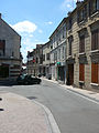 Part of Rue St Etienne d'Orves, the main street
 -
 The village green
 -
![Dovecote (colombier), a remnant of the village surrounded by 20 large houses,[5] now surrounded by apartment blocks](//upload.wikimedia.org/wikipedia/commons/thumb/8/89/Colombier%2C_Voie_de_l%27Aulne%2C_Verri%C3%A8res-le-Buisson.JPG/120px-Colombier%2C_Voie_de_l%27Aulne%2C_Verri%C3%A8res-le-Buisson.JPG) Dovecote (colombier), a remnant of the village surrounded by 20 large houses,[5] now surrounded by apartment blocks
Dovecote (colombier), a remnant of the village surrounded by 20 large houses,[5] now surrounded by apartment blocks


![Dovecote (colombier), a remnant of the village surrounded by 20 large houses,[5] now surrounded by apartment blocks](http://upload.wikimedia.org/wikipedia/commons/thumb/8/89/Colombier%2C_Voie_de_l%27Aulne%2C_Verri%C3%A8res-le-Buisson.JPG/120px-Colombier%2C_Voie_de_l%27Aulne%2C_Verri%C3%A8res-le-Buisson.JPG)
See also
 France portal

References
- Mayors of Essonne Association (in French)
- ^ "Répertoire national des élus: les maires" (in French). data.gouv.fr, Plateforme ouverte des données publiques françaises. 13 September 2022.
- ^ "Populations légales 2021". The National Institute of Statistics and Economic Studies. 28 December 2023.
- ^ Population en historique depuis 1968, INSEE
- ^ "Office Locations Archived 2011-08-10 at the Wayback Machine." Kroll Inc. Retrieved on 14 August 2011. "Paris (Kroll Ontrack) 2, impasse de la Noisette 91371 Verriéres-le-Buisson, Cedex 413 France"
- ^ Tourism Office historic houses page
External links
 Media related to Verrières-le-Buisson at Wikimedia Commons
- Official website (in French)
- Base Mérimée: Search for heritage in the commune, Ministère français de la Culture. (in French)
- v
- t
- e

- Antony
- Le Blanc-Mesnil
- Bobigny
- Bondy
- Cergy
- Chelles
- Clamart
- Clichy
- Corbeil-Essonnes
- Drancy
- Épinay-sur-Seine
- Évry-Courcouronnes
- Fontenay-sous-Bois
- Issy-les-Moulineaux
- Ivry-sur-Seine
- Levallois-Perret
- Maisons-Alfort
- Massy
- Meaux
- Neuilly-sur-Seine
- Noisy-le-Grand
- Pantin
- Saint-Maur-des-Fossés
- Saint-Ouen-sur-Seine
- Sarcelles
- Sartrouville
- Sevran
- Villejuif
- Alfortville
- Athis-Mons
- Bagneux
- Bagnolet
- Bezons
- Bois-Colombes
- Brétigny-sur-Orge
- Brunoy
- Bussy-Saint-Georges
- Cachan
- Champs-sur-Marne
- Charenton-le-Pont
- Châtenay-Malabry
- Châtillon
- Chatou
- Le Chesnay-Rocquencourt
- Choisy-le-Roi
- Clichy-sous-Bois
- Conflans-Sainte-Honorine
- Cormeilles-en-Parisis
- La Courneuve
- Creil
- Draveil
- Dreux
- Eaubonne
- Élancourt
- Ermont
- Étampes
- Fontenay-aux-Roses
- Franconville
- Fresnes
- Gagny
- La Garenne-Colombes
- Garges-lès-Gonesse
- Gennevilliers
- Gonesse
- Goussainville
- Grigny
- Guyancourt
- L'Haÿ-les-Roses
- Herblay-sur-Seine
- Houilles
- Limeil-Brévannes
- Livry-Gargan
- Malakoff
- Mantes-la-Jolie
- Melun
- Meudon
- Montfermeil
- Montigny-le-Bretonneux
- Montrouge
- Les Mureaux
- Neuilly-sur-Marne
- Nogent-sur-Marne
- Noisy-le-Sec
- Palaiseau
- Le Perreux-sur-Marne
- Pierrefitte-sur-Seine
- Plaisir
- Le Plessis-Robinson
- Poissy
- Pontault-Combault
- Pontoise
- Puteaux
- Rambouillet
- Ris-Orangis
- Romainville
- Rosny-sous-Bois
- Saint-Cloud
- Saint-Germain-en-Laye
- Sainte-Geneviève-des-Bois
- Sannois
- Savigny-sur-Orge
- Savigny-le-Temple
- Stains
- Sucy-en-Brie
- Suresnes
- Taverny
- Thiais
- Trappes
- Tremblay-en-France
- Les Ulis
- Vanves
- Vigneux-sur-Seine
- Villemomble
- Villeneuve-Saint-Georges
- Villeparisis
- Villepinte
- Villiers-le-Bel
- Villiers-sur-Marne
- Vincennes
- Viry-Châtillon
- Yerres
- 1,792 other communes

Authority control databases | |
|---|---|
| International |
|
| National |
|
| Geographic |
|
 | This Essonne geographical article is a stub. You can help Wikipedia by expanding it. |
- v
- t
- e


