Weert, Antwerp
Village in Flemish Region
51°06′08″N 4°11′24″E / 51.10229°N 4.18998°E / 51.10229; 4.18998 Belgium
 (2021)[1]
Weert is a village in the municipality of Bornem, Antwerp Province, Belgium.
The village used to located on the left bank of the Scheldt, but the river changed course during the 13th century, and it is now located on the right bank. The village was first mentioned in 1240 when it was sold to the Saint Bavo's Abbey in Ghent for cultivation. Around 1320, the area was enclosed by dikes.[2] Weert was an independent municipality until 1977, when it was merged into Bornem.[3]
Gallery
-
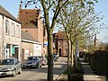 Street view
 -
 View from the dike
 -
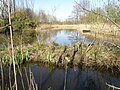 Moor near Weert


References
- Weert, Antwerp at GEOnet Names Server
Wikimedia Commons has media related to Weert (Bornem).
- v
- t
- e
Belgian municipality Bornem
- Bornem
- Hingene
- Mariekerke [nl]
- Weert
- Wintam [nl]
- Bornem Abbey
- Bornem Castle
- Dodentocht
- D'Ursel Castle
- Temse Bridge
 Category
 Commons
 Belgium Portal


 | This Antwerp Province location article is a stub. You can help Wikipedia by expanding it. |
- v
- t
- e


