West Dummerston Covered Bridge
United States historic place
West Dummerston Covered Bridge | |
 | |
42°56′12″N 72°36′49″W / 42.93667°N 72.61361°W / 42.93667; -72.61361 | |
| Area | 1 acre (0.40 ha) |
|---|---|
| Built | 1872 (1872) |
| Architect | Lamson, Caleb B. |
| Architectural style | Town lattice truss |
| NRHP reference No. | 73000207[1] |
| Added to NRHP | May 08, 1973 |
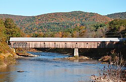
The West Dummerston Covered Bridge is a historic covered bridge spanning the West River in Dummerston, Vermont, between Vermont Route 30 and Camp Arden Road. Built in 1872, it is at 280 feet (85 m) the longest covered bridge entirely within the state of Vermont. It was listed on the National Register of Historic Places in 1973.[1]
Description and history
The West Dummerston Covered Bridge is located in west-central Dummerston, a short way north of the village of West Dummerston. It spans the West River in a roughly east–west direction, and is mounted on stone abutments and a central stone pier. The bridge consists of two spans, each supported by Town lattice trusses, and has a total structure length of 280 feet (85 m). The sides of the bridge are finished in flush vertical boards, and the ends are sheathed in wooden clapboards. The roof is of corrugated metal, laid over an older wooden shingle roof. The side walls have diamond-shaped openings cut in them to admit additional light.[2]
The bridge was built in 1872 by master builder Caleb Lamson, and is the only known surviving example of his work in Windham County. It is the longest covered bridge entirely within the state: the Scott Covered Bridge in Townshend is 277 feet (84 m) long, and the Cornish–Windsor Covered Bridge (spanning the Connecticut River into New Hampshire) is the nation's longest, at 449 feet (137 m).

See also
- List of Vermont covered bridges
- National Register of Historic Places listings in Windham County, Vermont
- List of bridges on the National Register of Historic Places in Vermont
References
- ^ a b "National Register Information System". National Register of Historic Places. National Park Service. March 13, 2009.
- ^ "NRHP nomination for West Dummerston Covered Bridge". National Park Service. Retrieved 2016-01-11.
External links
 Media related to West Dummerston Covered Bridge at Wikimedia Commons
- v
- t
- e
National Register of Historic Places in Windham County, Vermont
Historic
Landmarks
- Naulakha
- Rockingham Meetinghouse

- Bellows Falls Downtown Historic District
- Bellows Falls Neighborhood Historic District
- Brattleboro Downtown Historic District
- Canal Street–Clark Street Neighborhood Historic District
- Crows Nest
- Dickinson Estate Historic District
- Follett Stone Arch Bridge Historic District
- George–Pine–Henry Street Historic District
- Grafton Village Historic District
- Homestead–Horton Neighborhood Historic District
- Houghtonville Historic District
- Mechanicsville Historic District
- Middletown Rural Historic District
- Moore and Thompson Paper Mill Complex
- Newfane Village Historic District
- Parker Hill Rural Historic District ‡
- Putney Village Historic District
- Rockingham Village Historic District
- Saxtons River Village Historic District
- Scott Farm Historic District
- Samuel Gilbert Smith Farmstead
- South Londonderry Village Historic District
- South Windham Village Historic District
- Stratton Mountain Lookout Tower
- Townshend State Park
- Vermont Academy Campus Historic District
- West Brattleboro Green Historic District
- West Dover Village Historic District
- West Townshend Village Historic District
- Westminster Terrace Historic District
- Westminster Village Historic District
- Whitingham Village Historic District
- Williams Street Extension Historic District
- Wilmington Village Historic District
- Windham Village Historic District
| Commercial | |
|---|---|
| Educational/ Health |
|
| Government |
|
| Industrial | |
| Religious |
|
| Residential |
|
| Transportation |
|
- Bartonsville Covered Bridge
- Bridge 19
- Creamery Covered Bridge
- East Putney Brook Stone Arch Bridge
- Green River Covered Bridge
- Green River Crib Dam
- Hall Covered Bridge
- Kidder Covered Bridge
- Medburyville Bridge
- Rice Farm Road Bridge
- Sacketts Brook Stone Arch Bridge
- Scott Covered Bridge
- Simpsonville Stone Arch Bridge
- South Newfane Bridge
- West Dummerston Covered Bridge
- West Townshend Stone Arch Bridge
- Williams River Route 5 Bridge
- Williamsville Covered Bridge
- Worrall Covered Bridge
‡ This historic property also has portions in an adjacent county.


