Zavet (town)
Place in Razgrad, Bulgaria
Zavet Завет | |
|---|---|
 Seal | |
| 43°46′N 26°40′E / 43.767°N 26.667°E / 43.767; 26.667 | |
| Country | Bulgaria |
| Provinces (Oblast) | Razgrad |
| Government | |
| • Mayor | Ahter Veliev |
| Elevation | 265 m (869 ft) |
| Population (2008)[1] | |
| • Total | 3,585 |
| Time zone | UTC+2 (EET) |
| • Summer (DST) | UTC+3 (EEST) |
| Postal Code | 7330 |
| Area code | 08342 |
Zavet (Bulgarian: Завет, pronounced [ˈzavɛt]; Turkish: Zavut) is a town in northeastern Bulgaria, part of Razgrad Province and located in the geographic region of Ludogorie. It is the administrative centre of the homonymous Zavet Municipality, which lies in the northern part of Razgrad Province. Zavet is situated in the western Ludogorie Plateau, 12 kilometres from Isperih and Kubrat, and 35 kilometres from Tutrakan and Razgrad.
Zavet used to be a village in the 1970s, when Ostrovo was the municipal centre. In 1974, Zavet was promoted to the municipal centret, thus depriving Ostrovo of its status.
Municipality
Zavet municipality includes the following 7 places:
|
Honour
Zavet Saddle on Smith Island, South Shetland Islands is named after Zavet.
Gallery
-
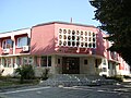 Municipality building
 -
 A building in the centre of the town
 -
 Chitalishte of the town at the centre


External links
- Zavet municipality website (in Bulgarian)
- Zavet town website (in Bulgarian)
- Time capsule message dated Feb. 4, 1915, noting the cornerstone laying for a building to house the Samorazvitie Community Center & Public Library in Zavet, District of Razgrad, Bulgaria. (English)
- v
- t
- e

- Sofia (capital)

- Balchik
- Bankya
- Berkovitsa
- Byala Slatina
- Cherven Bryag
- Chirpan
- Elhovo
- Etropole
- Gotse Delchev
- Harmanli
- Ihtiman
- Karnobat
- Kavarna
- Knezha
- Kostinbrod
- Kozloduy
- Mezdra
- Nesebar
- Novi Iskar
- Novi Pazar
- Panagyurishte
- Parvomay
- Pavlikeni
- Peshtera
- Pomorie
- Popovo
- Provadia
- Radnevo
- Radomir
- Rakovski
- Razlog
- Stamboliyski
- Svilengrad
- Aksakovo
- Bansko
- Belene
- Belogradchik
- Beloslav
- Bobov Dol
- Bozhurishte
- Byala, Ruse Province
- Chepelare
- Devin
- Devnya
- Dolni Chiflik
- Dryanovo
- Dulovo
- Elena
- Elin Pelin
- Galabovo
- General Toshevo
- Hisarya
- Isperih
- Kostenets
- Kotel
- Krichim
- Krumovgrad
- Kubrat
- Kuklen
- Levski
- Lukovit
- Lyaskovets
- Lyubimets
- Madan
- Momchilgrad
- Omurtag
- Oryahovo
- Perushtitsa
- Pirdop
- Rakitovo
- Saedinenie
- Septemvri
- Simeonovgrad
- Simitli
- Slivnitsa
- Sopot, Plovdiv Province
- Sredets
- Straldzha
- Svoge
- Tervel
- Teteven
- Topolovgrad
- Tryavna
- Tsarevo
- Tutrakan
- Tvarditsa
- Varshets
- Veliki Preslav
- Yakoruda
- Zlatitsa
- Zlatograd
- Aheloy
- Apriltsi
- Ardino
- Banya
- Batak
- Batanovtsi
- Belitsa
- Belovo
- Borovo
- Bratsigovo
- Bregovo
- Breznik
- Byala
- Chernomorets
- Dalgopol
- Debelets
- Dobrinishte
- Dolna Banya
- Dolna Mitropoliya
- Dolna Oryahovitsa
- Dolni Dabnik
- Dospat
- Dragoman
- Dunavtsi
- Dve Mogili
- Dzhebel
- Glodzhevo
- Godech
- Gulyantsi
- Gurkovo
- Hadzhidimovo
- Ignatievo*
- Iskar
- Ivaylovgrad
- Kableshkovo
- Kalofer
- Kameno
- Kaspichan
- Kilifarevo
- Klisura
- Kocherinovo
- Koprivshtitsa
- Kostandovo
- Koynare
- Kresna
- Kran
- Krivodol
- Kula
- Laki
- Letnitsa
- Loznitsa
- Maglizh
- Malko Tarnovo
- Marten
- Мizia
- Nedelino
- Nikolaevo
- Nikopol
- Obzor
- Opaka
- Pavel Banya
- Polski Trambesh
- Pordim
- Pravets
- Primorsko
- Rila
- Roman
- Rudozem
- Sadovo
- Sapareva Banya
- Sarnitsa
- Shabla
- Shivachevo
- Slavyanovo
- Slivo Pole
- Smyadovo
- Sozopol
- Strazhitsa
- Strelcha
- Sungurlare
- Suvorovo
- Sveti Vlas
- Tran
- Trastenik
- Tsar Kaloyan
- Ugarchin
- Valchedram
- Valchi Dol
- Varbitsa
- Vetovo
- Vetren
- Yablanitsa
- Zavet
- Zlataritsa
- city status after the census of 01.02.2011: Ignatievo, Kran
| |
|---|---|
Capital: Zavet | |
| Villages |
|
| Landmarks | |
| Culture | |
| Notable people | |
Authority control databases | |
|---|---|
| International |
|
| National |
|
43°46′N 25°40′E / 43.767°N 25.667°E / 43.767; 25.667
 | This Razgrad Province, Bulgaria location article is a stub. You can help Wikipedia by expanding it. |
- v
- t
- e


