Caerphilly (county borough)
Unitaire autoriteit in Wales  | |||
|---|---|---|---|
 | |||
| Coördinaten | 51°39'22"NB, 3°10'59"WL | ||
| Algemeen | |||
| Oppervlakte | 277,3879[1] km² | ||
| Inwoners | 181019 (2018)[2] (653 inw./km²) | ||
| Grootste plaats | Caerphilly | ||
| Bestuurlijke status | county borough | ||
| Welsh sprekend | 16,7% | ||
| Overig | |||
| ISO 3166-2 | GB-CAY | ||
| ONS-code | W06000018 | ||
| Officiële website | caerphilly.gov.uk | ||
| |||

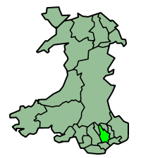
Caerphilly (Welsh: Caerffili) is een unitaire autoriteit in het zuiden van Wales in het grensgebied van de historische graafschappen Glamorgan en Monmouthshire. Het bestuurlijke centrum is Hengoed en de grootste plaats is het gelijknamige Caerphilly. De county borough heeft 181.000 inwoners.
Plaatsen
|
|
Bronnen, noten en/of referenties

Graafschappen: Anglesey · Carmarthenshire · Ceredigion · Denbighshire · Flintshire · Gwynedd · Monmouthshire · Pembrokeshire · Powys
County boroughs: Blaenau Gwent · Bridgend · Caerphilly · Conwy · Merthyr Tydfil · Neath Port Talbot · Rhondda Cynon Taf · Torfaen · Vale of Glamorgan · Wrexham
Steden: Cardiff · Newport · Swansea
Zie ook: behouden graafschappen (preserved counties) en de historische graafschappen


