Le Tâtre
Gemeente in Frankrijk  | |||
|---|---|---|---|
  | |||
| Situering | |||
| Regio | Nouvelle-Aquitaine | ||
| Departement | Charente (16) | ||
| Arrondissement | Cognac | ||
| Kanton | Charente-Sud | ||
| Coördinaten | 45° 24′ NB, 0° 12′ WL | ||
| Algemeen | |||
| Oppervlakte | 6,13 km² | ||
| Inwoners (1 januari 2021) | 423[1] (69 inw./km²) | ||
| Hoogte | 73 - 143 m | ||
| Overig | |||
| Postcode | 16360 | ||
| INSEE-code | 16380 | ||
| Detailkaart | |||
 | |||
| Foto's | |||
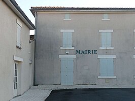 | |||
| Gemeentehuis | |||
| |||

Le Tâtre is een gemeente in het Franse departement Charente (regio Nouvelle-Aquitaine) en telt 314 inwoners (2005). De plaats maakt deel uit van het arrondissement Cognac.
Geografie
De oppervlakte van Le Tâtre bedraagt 6,1 km², de bevolkingsdichtheid is 51,5 inwoners per km².
De onderstaande kaart toont de ligging van Le Tâtre met de belangrijkste infrastructuur en aangrenzende gemeenten.
 |
Demografie
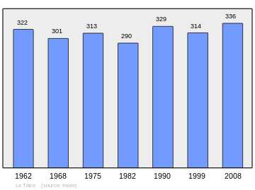
Onderstaande figuur toont het verloop van het inwonertal (bron: INSEE-tellingen).
Externe links
- (fr) Statistische informatie op de website van INSEE
Mediabestanden
Zie de categorie Le Tâtre van Wikimedia Commons voor mediabestanden over dit onderwerp.
- ↑ Populations légales 2021.


